Esri Technical Support Blog - Page 2

cancel
Showing results for 
Show  only  | Search instead for 
Did you mean: 

Latest Activity

(383 Posts)
MelissaJarman
Esri Contributor

Esri Developer Network (EDN) licenses, Site License Agreements (SLAs), educational site licenses, and other license agreements require that the license files for ArcGIS for Server and ArcSDE enterprise geodatabases be updated upon or prior to expiration for continued use. In previous versions of ArcSDE, the Authorization section of the ArcSDE Post Installation Wizard performed the task of updating the license information for the geodatabase. Because there is no Post Installation Wizard for ArcSDE at version 10.1, this process has changed.


Below are the two methods for updating the ArcSDE enterprise geodatabase license for your organization – either before or after it has expired.

Update enterprise geodatabase license before it expires


To update the geodatabase license before it expires, you can apply a manual approach using the ArcSDE command line tools. The sdesetup –o update_key is a command line tool that can be used to update the license prior to expiration. You may be familiar with this tool if the license file was ever updated manually in previous versions. Keep in mind that many of the ArcSDE command line tools are being migrated into user interface tools and this process may change in future releases.
  • If ArcGIS for Server was previously authorized with the new license, simply reference the keycodes file using the sdesetup –o update_key command.
  • If you have not authorized ArcGIS for Server with the new ECP license number, please use the following steps:

1.    Obtain a valid ECP registration number from the Customer Care Portal.

2.   Use the Authorization portion of the ArcGIS Server Post Installation Wizard. This creates or updates the keycodes file with the new license information.

3.   Use the sdesetup –o update_key command, referencing the updated keycodes file. The keycodes files can be found in the directory similar to the following: C:\Program Files\ESRI\License\sysgen


Please see the ArcSDE Administration Commands reference that is included with the installation for specifics on this command. The sdesetup command line tools must be installed from the Customer Care Portal for your specific database type.

NOTE: These specific sdesetup commands are not included with the general ArcSDE command line tool install as they are specific to each RDBMS. See KB39857 - FAQ: Where are the ArcSDE administration commands at 10.1?


Below is an example of using the keycodes file with the sdesetup –o update_key command.sdesetup.png

Update enterprise geodatabase license after expiration


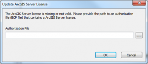
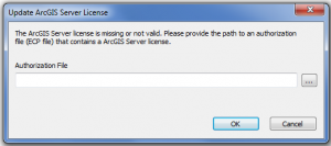
At version 10.1 a new prompt displays when an administrative user makes a database connection to a geodatabase that has an expired license. This prompt is the Update ArcGIS Server License dialog box. It accepts physical ECP files or the keycodes file from your ArcGIS Server installation.update_arcgis_license-300x130.pngIMPORTANT: Currently you will need to add a file extension onto the end of the keycodes file (.txt or .ecp).There is a bug logged for this:

NIM089984 - Update ArcGIS Server License tool for expired ArcSDE geodatabases does not accept keycodes file as valid input to update the geodatabase license.


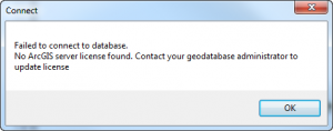
Also, keep in mind if you are not the administrative user you will receive an error message to contact your geodatabase administrator to make the database connection and update the license for the geodatabase:not_admin-300x118.png

Tips/Facts:

    • It is currently not possible to run the Update ArcGIS Server License tool if the license for the geodatabase is still valid.
    • At version 10.1 the sdesetup –o update_key option works to update the license for the enterprise geodatabase (–o install and –o upgrade options no longer work at this release).
    • At version 10.1 the command line tools still accept the full direct connect syntax for the –i parameter (e.g. sde:sqlserver:instance).
    • The Esri Customer Care Portal provides access to ECPXXXX registration numbers but not the physical authorization files (.ecp). It is recommended to use keycodes files when authorizing ArcSDE geodatabases.
    • Keycodes files can be found in the following directory: C:\Program Files\ESRI\License\sysgen
    • It is always recommended to use the keycodes file when possible. In the case of needing a physical .ecp file, use the Customer Care form: ArcSDE 10 Authorization Form(works for both versions 10.0 and 10.1).

Additional References:

How To: Update an Educational Site License or EDN license in an enterprise geodatabaseHow To: Update an Educational Site License or EDN license in a workgroup geodatabaseFAQ: Where are the ArcSDE administration commands at 10.1?How to get an authorization file or keycodes file for the new Create Enterprise Geodatabase tool at ...Melissa J. - Geodata Support Analyst

more
0 1 5,645
MeganSingleton
Occasional Contributor III

A lot of changes were made at ArcGIS for Desktop 10.1 regarding database connections within the client software. The ‘Add Spatial Database Connection’ dialog is renamed to  ‘Add Database Connection’, and new functionality is added, allowing connections to enterprise geodatabases and other supported databases.

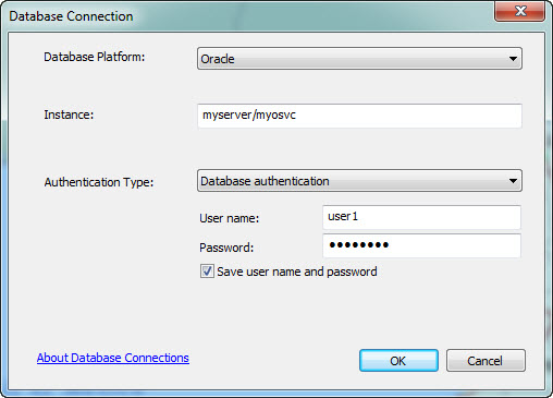
At the 10.1 release, we introduced support for the Oracle Easy Connect string when making these connections. This is a simpler Oracle naming method connect string that you can use within the Instance parameter of your Database Connection properties. The Easy Connect naming method eliminates the need for service name lookups in the tnsnames.ora file for TCP/IP environments.  No naming or directory systems are required if you use this method.


The Oracle Instant Client is a lightweight manual install. You can obtain the Oracle Instant, Runtime, or Administrator Client from Oracle and install the client on the client computer, following the directions in your Oracle documentation. It is comprised of the minimum required files necessary for making database connections using an Esri Client; however, it does not contain any executables or configuration/migration tools.

The setup process is quick:

  1. Unzip the downloaded contents into a directory.
  2. Add the location of the Oracle Instant Client directory within the system path environment variable.
    1. Example: c:appinstantclient_11_2
  3. Test out a new database connection in ArcCatalog.
    1. You can also test the connection in the Catalog window in ArcMap.

TIPS:

  • For making database connections within ArcGIS for Desktop, use the 32-bit Oracle Instant Client.
  • For using the Easy Connect string with other Oracle clients, make sure the sqlnet.ora file has EZCONNECT specified within the NAMES.DIRECTORY_PATH parameter (the Instant Client does not include this file by default).
  • Make sure the database instance is configured for EZCONNECT.
oracleeasyconnect.jpg

Making database and geodatabase connections at 10.1 just got a little easier - happy connecting!

References

Melissa J. - Geodata Support Analyst

more
0 0 1,610
MeganSingleton
Occasional Contributor III

With the changes in how new enterprise ArcSDE geodatabases are created in ArcGIS 10.1, I wanted to share a few tips on how to authorize your geodatabase when it is created, when it is upgraded, and when your license has expired.


Before version 10.1, the Post Installation Wizard allowed you to authorize enterprise geodatabases with an authorization file or by using the ECP registration number from the Customer Care Portal. If the registration number was used, the Post Installation Wizard had an option to register online, which validated the registration number with your customer information and populated the necessary system tables. At the 10.1 release, the Create Enterprise Geodatabase and Enable Enterprise Geodatabase tools require the .ecp file or the keycodes file for authorization.

Creating New Geodatabases

At ArcGIS 10.1, two new tools have been added to the Geodatabase Administration toolbox: Create Enterprise Geodatabase and Enable Enterprise Geodatabase. The Create Enterprise Geodatabase tool performs the geodatabase administrator creation, geodatabase creation, and authorization functions previously performed through the ArcSDE for SQL Server, Oracle, and PostgreSQL Post Installation wizards on Windows.

TIP: Within the Customer Care Portal you have access to the ECP registration number, but this format of the license information is not a valid input for the Create Enterprise Geodatabase tool. If you are an ArcSDE administrator and have been using ArcSDE for several releases you may be wondering where to get the correct file format for these new tools at 10.1. You'll need to authorize ArcGIS Server first and use the keycodes file, or obtain a physical .ecp authorization file.

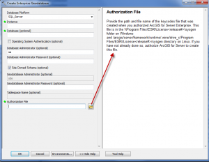
The Create Enterprise Geodatabase and Enable Enterprise Geodatabase tools' Help documentation gives a summary of what is needed for the authorization file and the path that can be used to locate the keycodes file.

Examples of valid input for the Authorization File field in this tool include the keycodes file within the ArcGIS for Server Enterprise directory and the physical .ecp authorization file.

6-26-2012-2-29-23-PM-300x232.png

NOTE: You must have authorized ArcGIS Server to create the keycodes file ahead of time!

Upgrading Existing Geodatabases

If there is a valid license in the geodatabase when upgrading (Upgrade Geodatabase tool), you will not be prompted for this information. If the license has expired, you will be prompted to navigate to a valid license to update the database tables.

Expired Enterprise Geodatabase License

In the case of an expired geodatabase license, the geodatabase administrator is prompted with an Update ArcGIS Server License dialog box when making a database connection.

expired_license-300x133.png

This tool guides you through updating the ArcSDE enterprise geodatabase license if it has expired. This populates the database server_config table with the updated license information.

Previous Tools from the Customer Care Site

The ArcSDE and ArcIMS Authorization Form on the Esri Customer Care site can still be used to convert your registration numbers to physical .ecp files if this is preferred; however, the keycodes file can be used interchangeably with the .ecp file.

Helpful Links

ArcGIS 10.1 for Server Enterprise Quick Start Guide (Including ArcGIS 10.1 Spatial Data Server and ArcSDE 10.1)  > See the Authorize ArcSDE section

Melissa J. - Geodata Support Analyst

more
2 0 18.9K
by Anonymous User
Not applicable

Service Pack 5 for ArcGIS 10.0 has been released. Please visit the ArcGIS Resource Center Blog for more information about this release: ArcGIS 10.0 Service Pack 5.

This service pack is available for download via the ArcGIS Resource Center: ArcGIS 10.0 SP5 (Desktop, Engine, and Server)

For the best experience, please download this service pack at your earliest convenience.

Service packs for other products include:

more
0 0 436
by Anonymous User
Not applicable

Marker.jpg

The fabled blue marker, what do you do?!


Our lives are filled with things we often overlook. Case in point, what are the little blue reflectors on the road that you see on the way home from work every day? I've tried to establish a pattern. Are they marking the center of the lane? Sometimes they’re right on the road center line, sometimes they’re right in the middle of your wheel path, thump thump, and sometimes they’re barely on the road at all. If you look, you'll see them all the time; you just have no earthly clue as to what they actually do.

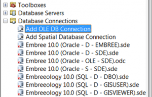
The OLE DB connection is not so different. It’s always sitting there in ArcCatalog staring right back at you under Database Connections. You usually skip right over it on your way to adding a Spatial Database Connection. Today, however, I urge you to stop, peer under the hood, and look at what an OLE DB connection can do.

The OLE DB connection is a window into the abyss, a.k.a. your geodatabase repository. This area is typically off limits. Perhaps your DBA isn’t a fan of people tinkering around in the RDBMS. Esri typically says “hands off” as well, since we don’t usually support errors caused by messing around with the underlying repository tables. Their sensitive nature aside, these tables can be quite helpful and using an OLE DB connection to access them is read-only, so it’s also safe. Your DBA can rest easy.

Many of the problems you might have during the course of a normal week might be sniffed out by using this connection. I typically use mine at least once a week, maybe even three or four times depending on how heavy my workload is. I’ll give a couple examples on how this connection can help.

Pretend, for a moment, that you’re trying to take your geodatabase to a fully compressed state (i.e., State 0). The dialog indicates that the process has completed successfully, but since you’re a rock star GIS professional, you know that a successful compression is not always indicative of a full compression.  So you crack open the OLE DB connection, scroll down to your compress_log table, and look up your end_state_count. It reveals that you have a count of 1. Since 0 is a state and is always present, you know that a count of 1 indicates that you’ve successfully achieved a full compression.

But what if the value isn't 1? What if the end_state_count reveals that there are two states remaining? Not a problem, you scroll down to the state_locks table, revealing that state_id 233 is being locked by sde_id 622. You then deftly maneuver up to the process_information table and you find that sde_id 622 is your SOC account. Then it dawns on you, you never did disconnect your web server, so you stop your web server, freeing up this connection and it’s resulting locks, compress again, and you’ve achieved full compression, all without ever cracking open Management Studio or SQL Developer and freaking out your DBA.
OLEDB1-300x192.png

Ye Ole Db Connection


Making the connection is relatively easy. Microsoft OLE DB connection drivers, which can handle Microsoft SQL Server and Oracle databases, are automatically installed. However, you may have to install the drivers for PostgreSQL databases yourself. Once installed, just click on “Add OLE DB Connection” within ArcCatalog, highlight the provider you want to use, fill out the requested information, and test the connection. If successful, click OK and you’re in! I know you 10.1 users are out there too. Don't worry, the link to opening an OLE DB connection is no longer on your ArcCatalog tree, but it's still around. It's now a button for your toolbar, so just click on Customize, go to Customize mode, select the Commands tab, highlight ArcCatalog, and drag the Add OLE DB Connection to your toolbar.

Good luck!

Oh yeah, the next time you see a blue marker on the road, glance to the right. I bet you’ll find a fire hydrant.Steven E. - Geodata Support Analyst


Edited on 4/27.

more
0 0 626
MeganSingleton
Occasional Contributor III

You may have already noticed some of the changes at 10.0 with the upgrade process for ArcSDE geodatabase no longer using the Post Installation wizard. This was discussed in an earlier blog written on "The Evolution of the ArcSDE Geodatabase Upgrade Process at 10.0". The ArcSDE Post Installation Wizard has made its grand exit and is no longer installed as part of ArcSDE at 10.1. Let’s take a look at the Post Installation steps and compare with the new geoprocessing tools that were created at 10.1 to perform similar tasks.

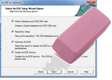
Post Installation Wizard Steps (Pre 10.1)

image0022.jpg
  • Define SDE User Environment/Define Database and SDE DBA User
  • Repository Setup
  • Authorize ArcSDE
  • Create ArcSDE Service

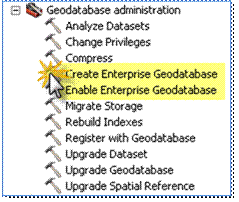
New Geoprocessing tools within Geodatabase Administration Toolbox at 10.1

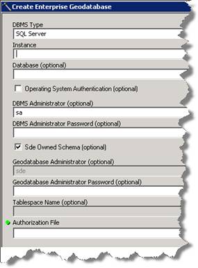
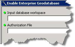
image004.gifThe following geoprocessing tools are within the Data Management Tools > Geodatabase Administration toolbox at 10.1:Create Enterprise Geodatabase – Create a database and geodatabase administrator in PostgreSQL or SQL Server and enable enterprise geodatabase functionality in it, or create a tablespace and geodatabase administrator in an existing Oracle database and enable enterprise geodatabase functionality in it. This tool also authorizes the software.image0061.jpgEnable Enterprise Geodatabase – Enable geodatabase functionality in an existing DB2, Informix, Oracle, PostgreSQL, or SQL Server database. This tool also authorizes the software.image0082.jpg

Application Server Services


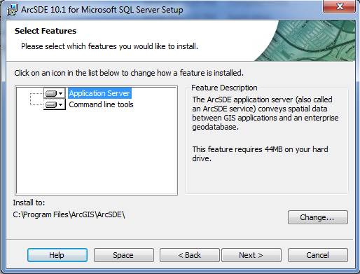
With the Post Installation Wizard no longer part of the ArcSDE install at 10.1, this also means that there is no wizard to create ArcSDE services. The ArcSDE install includes the application server along with command line tools.  If there is a need for an application server service at the 10.1 release, one can be manually created and registered (depending on DBMS) using the ArcSDE administration commands. See the ArcSDE Administration commands to reference the sdeservice commands.image0101.jpgMelissa J. - Geodata Support Analyst

more
0 0 1,038
40 Subscribers