- Home
- :
- All Communities
- :
- Services
- :
- Esri Technical Support
- :
- Esri Technical Support Blog
- :
- Having problems georeferencing your raster image?
Having problems georeferencing your raster image?
- Subscribe to RSS Feed
- Mark as New
- Mark as Read
- Bookmark
- Subscribe
- Printer Friendly Page
Have you ever added a raster image to your map document only to find that some of the georeferencing tools are not available? You know you've done this many times in the past, but what's different this time?
A quick test to identify any issues is to add the image to a new blank map document instead of an existing map document. If the tools are available in the new map document, then one of the reasons for the problem may be that your data frame in the existing map document is rotated. ArcMap can't apply a double-transformation to the raster.
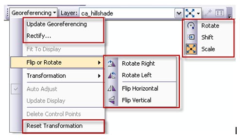
Here are the only functions available when the data frame is rotated:
- Update Georeferencing*
- Rectify*
- Reset Transformation*
- Flip or Rotate functions
- Rotate
- Shift
- Scale
*Available once image has been modified.

Simply clearing the data frame rotation will activate the following functions:
- Fit to Display
- Auto Adjust
- Add Control Points
- View Link Table
For more information on why your georeferencing toolbar may be grayed out, please reference the related links below.
-Timothy H., Support Analyst - Geodata Raster Group, Esri Support Services - Charlotte, NC
Related Links:
Problem: The georeferencing toolbar is greyed out
The GIS Encyclopedia: Georeference
Working with Rasters: Georeferencing
You must be a registered user to add a comment. If you've already registered, sign in. Otherwise, register and sign in.
-
Announcements
70 -
ArcGIS Desktop
87 -
ArcGIS Enterprise
43 -
ArcGIS Mobile
7 -
ArcGIS Online
22 -
ArcGIS Pro
14 -
ArcPad
4 -
ArcSDE
16 -
CityEngine
9 -
Geodatabase
25 -
High Priority
9 -
Location Analytics
4 -
People
3 -
Raster
17 -
SDK
29 -
Support
3 -
Support.Esri.com
60
- « Previous
- Next »