Turn on suggestions
Auto-suggest helps you quickly narrow down your search results by suggesting possible matches as you type.
Cancel
- Home
- :
- All Communities
- :
- Services
- :
- Esri Technical Support
- :
- Esri Technical Support Blog
- :
- Esri GRIDs are always 32 bit
Esri GRIDs are always 32 bit
Subscribe
1322
0
04-10-2012 01:34 AM
- Subscribe to RSS Feed
- Mark as New
- Mark as Read
- Bookmark
- Subscribe
- Printer Friendly Page
04-10-2012
01:34 AM
 There are many different kinds of rasters that can be used in ArcMap. To better describe and explain these different kinds of rasters, Esri has created help documentation on technical specifications and supported raster formats. Included in the documentation is the ESRI GRID format. This is a very flexible format that many users are comfortable using to process and display data. There is a unique aspect to this format that many users are unaware of that is mentioned in the help documentation.
A section in the help documentation on bit depth capacity reads,
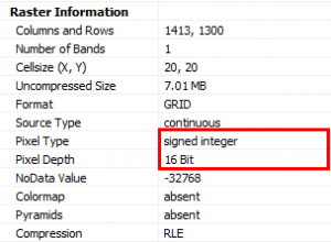
A grid dataset is always stored as 32 bit (either signed, unsigned, or floating point), but ArcGIS shows it above as being the most appropriate bit depth with regard to the cell values it contains.
So while the bit depth of the ESRI GRID may say 8 bit unsigned or 16 bit signed, the storage is still 32 bit. However, the properties in the source tab of the particular ESRI GRID raster may say something different. This is important when considering the behavior of the GRID compared to other formats like .imgs or .tifs.
This does not affect the average user of ESRI GRIDs, but just something to keep in mind and understand about the format. So fear not if you create a new ESRI GRID and the bit depth does not match your defined bit depth; it is still okay. Once the data is added,it should report the most appropriate bit depth. ESRI GRIDs are always 32 bit rasters regardless of what the source properties report.Jeff S. - Raster Support Analyst
Labels
You must be a registered user to add a comment. If you've already registered, sign in. Otherwise, register and sign in.
About the Author
GIS professional with specialties in rasters, remote sensing, 3D analysis and display, spatial analytics, some python skills and market research. Been with Esri for over 14 years and worked in the industry for over 20 years.
Labels
-
Announcements
70 -
ArcGIS Desktop
87 -
ArcGIS Enterprise
43 -
ArcGIS Mobile
7 -
ArcGIS Online
22 -
ArcGIS Pro
14 -
ArcPad
4 -
ArcSDE
16 -
CityEngine
9 -
Geodatabase
25 -
High Priority
9 -
Location Analytics
4 -
People
3 -
Raster
17 -
SDK
29 -
Support
3 -
Support.Esri.com
60
- « Previous
- Next »