Esri Technical Support Blog - Page 2

cancel
Showing results for 
Show  only  | Search instead for 
Did you mean: 

Latest Activity

(383 Posts)
KoryKramer
Esri Community Moderator

Nobody likes to talk about it, but sometimes computers can crash.  Yup, the entire thing just fails and nothing at all can be recovered (if you haven’t backed up your data, go do it now!) Or what if your laptop is stolen, or you flipped your kayak and your machine sank to the bottom of Lake Superior?  You just don’t have it anymore and there is absolutely nothing you can do to get it back. When these types of things happen, any Esri licenses that were authorized on the machine may be lost, too.

In the past, an authorized maintenance contact had to call Esri Technical Support to submit a license appeal and recover the lost licenses.  Now, this functionality is built in to My Esri, empowering your organization with self-service functionality and enabling you to get back up and running quickly.

I wanted to make sure that our customers are aware of this great new functionality and walk through how you’d go about getting your licenses back in the event of a catastrophic failure or loss as described above – though I really hope that never happens.

To perform the following steps, you will either need “Esri Admin” permission or the “Take Licensing Actions” permission. Sensitive information such as machine IDs, license numbers, and other personal information have been replaced with asterisks in the following screenshots.

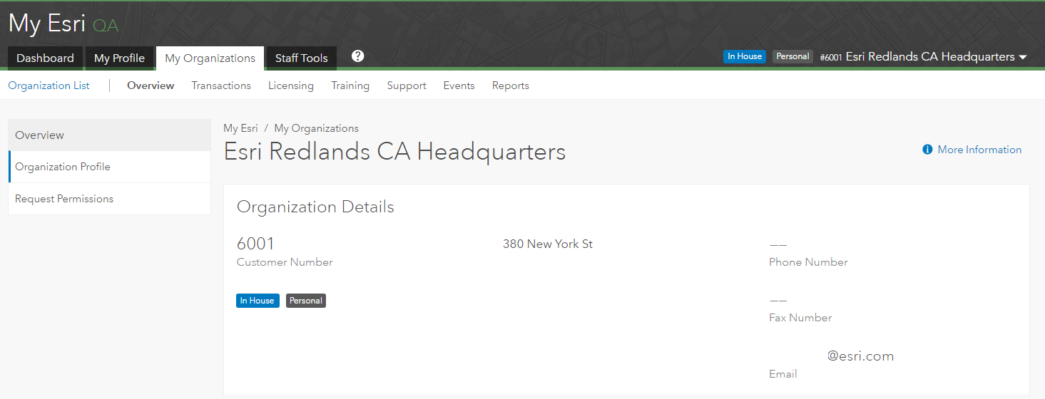
First, log in to My Esri and click the My Organizations tab.


Please note that I’m demonstrating the steps in a QA environment and that your experience won’t include the green QA…MyOrganizationTab.png

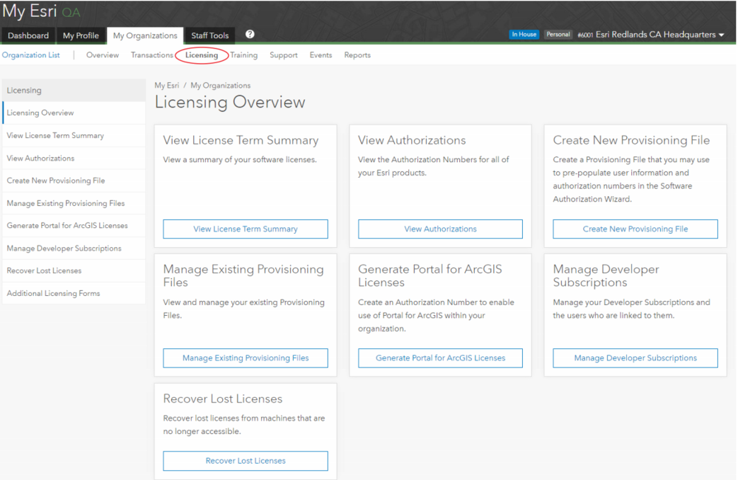
Click the Licensing tab.

LicensingOverview.png

This will bring up the Licensing Overview page and if you have the correct permissions, you should see the Recover Lost Licenses option both in the Licensing panel as well as a card.

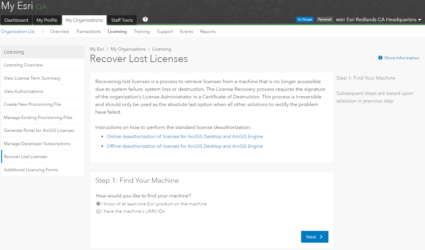
Next, click Recover Lost Licenses.


The Recover Lost Licenses screen explains that this is a process to retrieve licenses from a machine that is no longer accessible due to system failure, system loss, or destruction. The License Recovery process requires the signature of the organization’s License Administrator in a Certificate of Destruction. This process is irreversible and should only be used as the absolute last option when all other solutions to rectify the problem have failed.

An example of when you would not use the Recover Lost Licenses option is if you can still access the machine and deauthorize the licenses normally. The instructions provided describe how to perform standard license deauthorization:
Once you’ve determined that it really isn’t feasible to scuba dive to the bottom of Lake Superior to recover your machine (and hence, its licenses), follow the steps outlined below to complete the recovery.

Step 1: Find Your Machine


To proceed with license recovery, select how you would like to find the machine. There is an option to search by products on the machine or use the machine’s UMN IDs if you know those.FindYourMachine.png

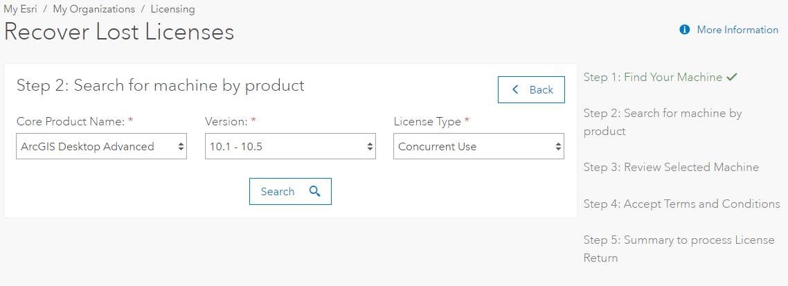
Step 2

Option A: Search for machine by product


Search for the machine by populating the dropdown boxes.SearchForMachine.png

Click Search.

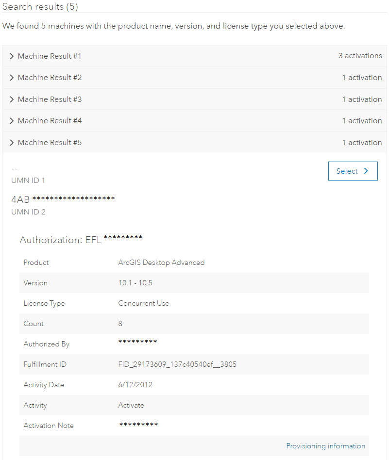
We see that the search for ArcGIS Desktop Advanced Concurrent Use licenses for this organization returns five machines.SearchResults2.png

Selecting the machine from which the licenses need to be recovered will take you to Step 3.

Option B: Select Machine using the UMN

SelectMachine1.png

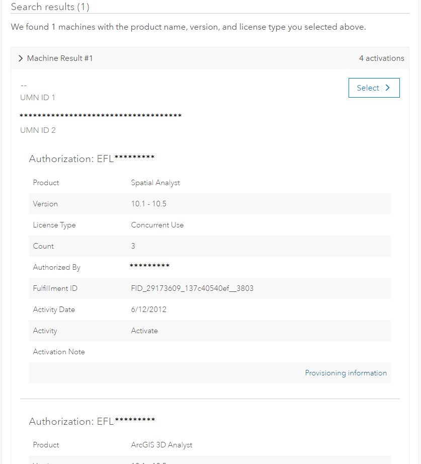
Enter the UMN for the machine and click Search.  Since the UMN by definition is associated with a single machine, you should get only one result in this case, as opposed to searching for a machine by product.SearchbyUMNresults1.png

Click Select to take you to Step 3.

Step 3: Review Selected Machine


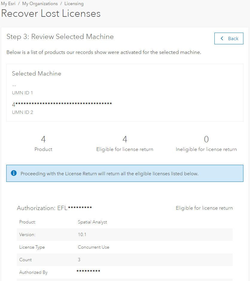
This step will show you a list of products our records show were activated for the selected machine.ReviewSelectedMachine1.png

After reviewing the selected machine, you have the option to go back if this is not the correct machine or proceed with the license recovery process.

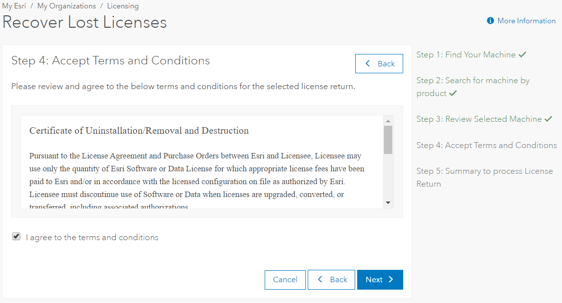
Step 4: Accept Terms and Conditions


Review and agree to the terms and conditions, and click Next.TermsAndConditions.png

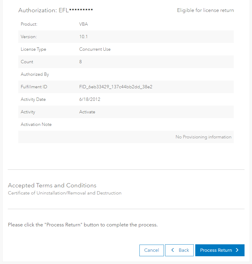
Step 5: Summary to process License Return


This step gives you another opportunity to fully review the selected licenses to return. If the selection is correct, click the “Process Return” button near the bottom of the page.SummaryToProcessReturn1.png

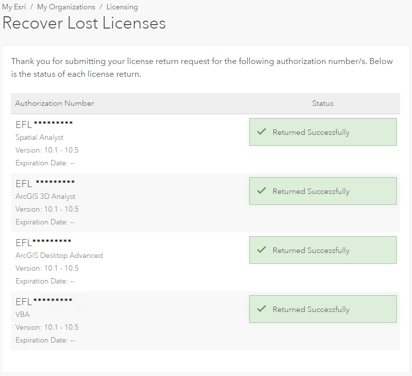
You’ll receive a confirmation screen showing the status of each license return.ReturnedSuccessfully1.png

And that’s it.  You are now able to authorize these licenses on a new, dry machine!

In the event that not all licenses are returned successfully, you will be presented with a summary of which licenses were returned and which were not. These should be exceptions; not the norm. In these cases, please work with Esri Customer Service or your local distributor to finalize the recovery process.
Kory K. - Customer Advocacy Lead

more
5 10 20.5K
by Anonymous User
Not applicable

As always, Esri Support aims to make your time with us as simple and pleasant as possible. We are constantly reviewing the ways we interact with you and making improvements so that you receive the best possible support from our highly qualified team of analysts.

Starting on April 3rd, we are deprecating the support@esri.com email address as a method for creating an Esri Support ticket. Instead, we request that all Email and Chat cases be created through the Support website.

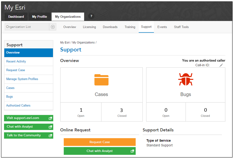
Many customers already use the website to request new cases. Clicking the "Request Case" link on the Support site prompts you to sign in and then opens the Request Case web form. You can use this web form to describe the issue you are facing and the Esri software product you are using. By using the preformatted web form, rather than an email, we can quickly route your case to a specialized Support Analyst who can begin helping you right away.

Support cases can also be opened from the Support page on My Esri. This means that all Support resources will be in one place - the creation, tracking, and history of case work all occurs through My Esri. When a case is requested through the web form, the process of creating the case and routing it to the right analyst is optimized and streamlined, so customers will be connected faster than they would if emailing directly.Myesri_screen1.png

We're very excited for the changes and updates being made to our Support website, and we're looking forward to providing even better support as a result!


Melissa Q. & Joseph M. - Support Services

more
0 0 1,711
MeganSingleton
Occasional Contributor III

Here at Esri Support, our goal is to provide you with a world-class support experience and ensure your success with the ArcGIS Platform--one element of this experience is online support.

Including this blog, Esri creates and maintains a vast network of online support resources, such as Support.Esri.com (which hosts a technical article knowledgebase, download links, product life cycle documentation, and more), Wiki.GIS.com, GeoNet forums (Esri Support actively uses the Esri Technical Support and ArcGIS Ideas places), the GIS Dictionary, among others.For us to continue creating the best resources possible, we request your feedback through a brief survey: Esri Online Support Resources Survey.

Your responses will help us understand your online support preferences and how Esri can deliver the resources you need.

Thank you in advance, and we look forward to supporting you in the future!Other Resources


Megan S. - Online Support Resources

more
0 0 603
GregoryLehner
Esri Contributor

Are you going to the Esri Developer Summit this year? Perhaps you have some questions or need help and would like some special assistance from our Technical Support Analysts? Come see us at the GIS Technical Support Island (TSI) in the Esri Showcase.

devsummit-support-300x225.jpg

The GIS Technical Support Island at Esri Dev Summit 2017


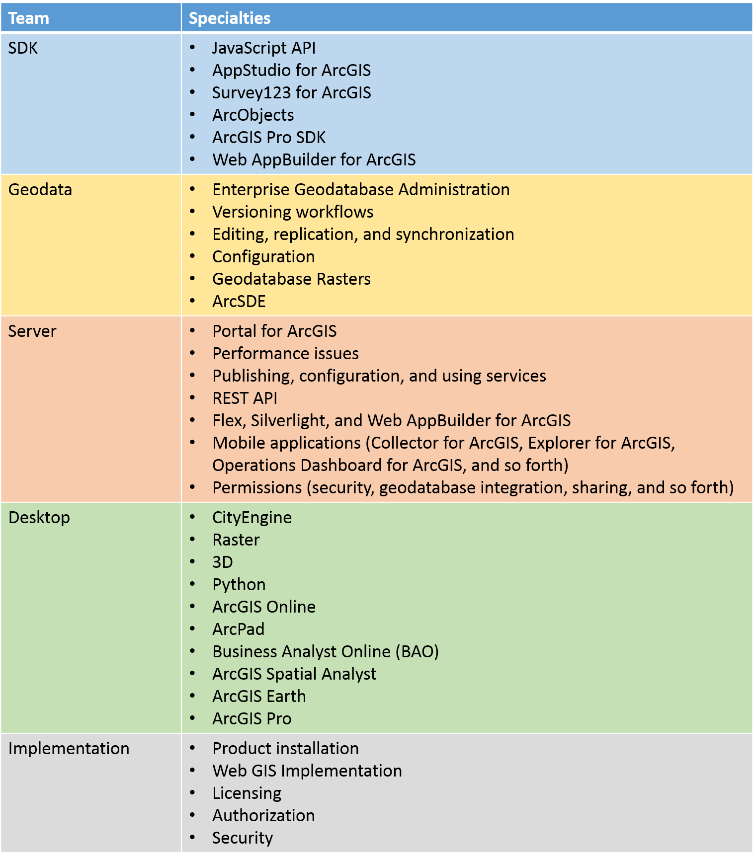
Esri Technical Support will have ten senior analysts available each day of the Developer Summit to assist customers with any technical questions or issues they may have with Esri products. These analysts are subject matter experts that span the many parts of the ArcGIS platform, so we should be able to help with most questions. However, if the problem is more complex, we will create a Support case and contact you later when you're available. We will be stationed right next to several other Esri services, including Consulting, Training, and Cloud Management. If your questions lead us to a conversation about one of our other services, we will connect you with an expert in that area, as well.

In Support, each of the following teams and specialties will be represented:DevSummit_Edited.pngOutside of the TSI, you can find Support Analysts throughout the summit, including at different sessions, demo theater presentations, and the Meet the Teams event.

Stop by and say hello!
Gregory L. - Online Support Resources

more
0 0 468
ThomasEdghill
Esri Community Moderator

02/06/2017 Update: Patches have been released for Portal for ArcGIS version 10.3 and 10.4, which can be found here. We are continuing to work on patches for ArcGIS Server Manager (10.2.x, 10.3, and 10.4) and Portal for ArcGIS (10.2.x). We appreciate your patience as these patches are being developed.11/23/2016 Update: Patches have been released for ArcGIS Server version 10.3.1 and 10.4.1, which can be found here. We are continuing to work on patches for ArcGIS Server Manager (10.2.x, 10.3, and 10.4) and Portal for ArcGIS (10.2.x, 10.3, and 10.4). We appreciate your patience as these patches are being developed.11/10/2016 Update: Patches have been released for Portal for ArcGIS versions 10.3.1 and 10.4.1, which can be found here. We are continuing to develop patches for ArcGIS Server Manager (10.2.x, 10.3.x, and 10.4.x) and Portal for ArcGIS at version 10.2.x, 10.3, and 10.4.

The forthcoming updates to the Firefox, Chrome, and Safari browsers cause errors in some web applications for ArcGIS Server and Portal for ArcGIS when users upload content.The following browser versions are affected:

  • Firefox 49 (Release Date: September 20, 2016)
  • Chrome 54 (Release Date: October 18, 2016)
  • Safari 10 (Release Date: September 20, 2016)
Note: Microsoft Internet Explorer and Microsoft Edge are not affected.The following ArcGIS products are affected:
  • ArcGIS Server 10.2.x, 10.3.x, and 10.4.x (patch deployed on 11/14/2016 for ArcGIS Server 10.3.1 and 10.4.1)
  • Portal for ArcGIS 10.2.x, 10.3, and 10.4 (patch deployed on 12/16/2016 for Portal for ArcGIS 10.3, 10.3.1, 10.4 and 10.4.1)
  • The ArcGIS API for JavaScript (patch deployed on 9/19/2016 for versions 3.11 and above.
The following workflows are affected:Portal for ArcGIS Home Application
  • Updating details for any content, such as items within “My Content” or fields within a user profile
  • Creating new groups via "Groups" > "Create A Group"
  • Uploading content via "My Content" > "Add Item" > "From my computer"
  • Uploading content to the Portal for ArcGIS Map Viewer via "Add" > "Add Layer from File"
  • Adding attachments when editing features in the Portal for ArcGIS Map Viewer
  • Updating thumbnails on any Item Details page or via "My Organization" > "Edit Settings" > "General"
  • Updating the banner or background images via "My Organization" > "Edit Settings" > "Home Page"

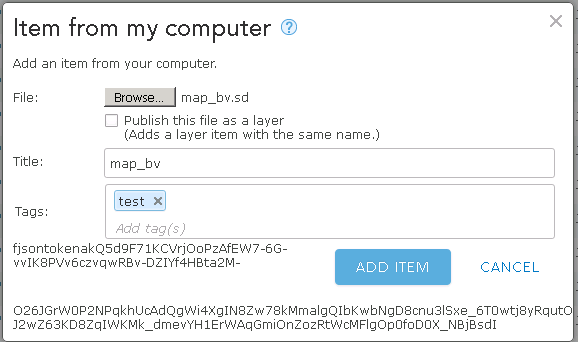
Below is an example of the error encountered when attempting to upload content in the Portal for ArcGIS home application.
PortalUploadError.png

This example shows the error which can be seen when trying to upload content to Portal for ArcGIS

ArcGIS Server Manager
  • Uploading service definitions (SD) when publishing services
  • Uploading SDE database connection files when registering a database as a data store
  • Uploading SOE or SOI files when adding extensions
  • Uploading KMZ files

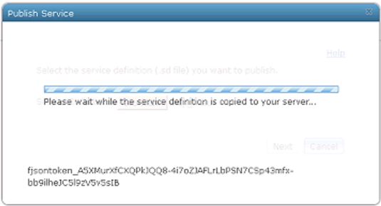
Below is an example of the error encountered when attempting to upload an SD in ArcGIS Server Manager.
ManagerUploadError.png

This example shows the error seen when uploading content to ArcGIS Server Manager


To resolve these errors, Esri is developing software patches for ArcGIS Server and Portal for ArcGIS. We will keep you informed as the patches become available.
Thomas E. - User Advocacy

more
0 0 2,874
Andrew--Johnson
Esri Regular Contributor

Get-map-data2.jpgThe CityEngine 2016.0 release was a ground breaking release. For those who are new to CityEngine and unfamiliar with the workflows, the new release cuts out a significant amount of time required to access and prepare data for use in CityEngine. For those who still want to use their own data…great!

You can find more information about preparing your data here.

For those who want a quick way of getting data and getting a CityEngine project up and running as quickly as possible, CityEngine 2016 is here to help with the Get map data wizard.

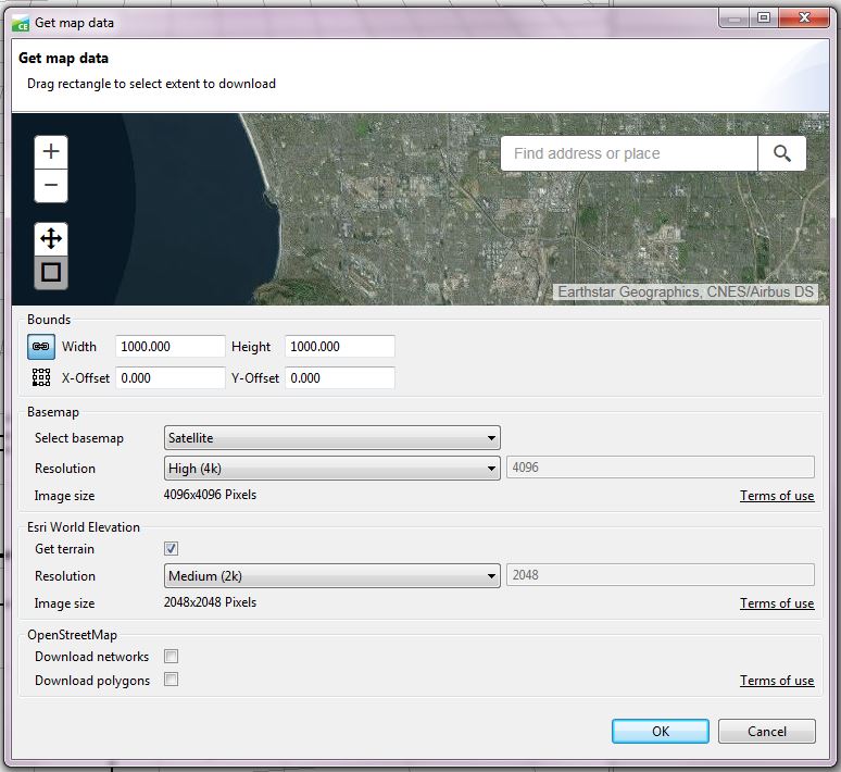
The Get map data wizard can be accessed by opening a scene in CityEngine and going to File > Get map data.  In the wizard, use the map to zoom to and select the area you want data from. The area selected can be from 500 m x 500 m to 100,000 m x 100,000 m. Three types of data can be grabbed by the wizard: Basemap, Esri World Elevation, and OpenStreetMap.

The basemap data is used as imagery (also referred to as texture) to be draped over the elevation layer. The basemap options allow you to select the basemap you want (Satellite, Streets, Topo, Dark Gray, or Light Gray), along with the image resolution. The resolution you select will determine the number of pixels the imagery has. The actual resolution of the imagery will depend on both the extent and resolution. For example, a 500 meter extent with a low resolution of 1024 pixels wide is less grainy than a 1,000 meter extent with the same resolution. As high resolution is not available across the globe, you may need to choose a lower resolution or larger area to get data. The Esri World Elevation will pull terrain data, or digital elevation model (DEM) data, from the Esri elevation service. OpenStreetMap data includes networks (streets) and polygons (building footprints).  OpenStreetMap is an open source, user-produced dataset, so coverage cannot be guaranteed, particularly for building footprints.

One thing to keep in mind when selecting data is that CityEngine is a memory intensive program and the larger the area and the higher the resolution, the more memory is required. If the computer has limited memory, you must consider that when selecting data to import.

With each new version of CityEngine, the software gets smarter, easier, and more groundbreaking. This blog only touched on the Get map data portion of the software, but there are more exciting features to check out, such as sharing scene packages, alembic modeling, and accessing data from ArcGIS Online. For a full list of new features, go here.


Rebecca R. & Andrew J. - Desktop Support

more
0 0 1,204
MeganSingleton
Occasional Contributor III

In 2014, we began My Esri as a one-stop shop for customers, a place for Esri’s global community to manage unique relationships with Esri. My Esri has grown steadily since launch, and we’re happy to announce that the site now includes support! Everything previously available on the legacy My Support site now calls My Esri home, and we’ve added some functionality, as well. Depending on your role within the organization, you can log cases, report bugs, view recent activity, and more.

There are many roles in My Esri, and this blog outlines some workflows and FAQs for of each participant: users, administrators, distributors, and Premium customers. Although we’ve segmented this post by user, the information under “For My Esri Users” contains valuable information for all. Note: If you don’t see the Support tab in My Esri, check out this blog post. If you’d like to know more how to use My Esri beyond what’s covered in this post, please see the Common Questions view in your Dashboard of My Esri (you must have an Esri account to view this page; see Get an Esri Account below). Additionally, you can take a tour of My Esri through the Take a Tour option. For My Esri UsersGet an Esri AccountTo use My Esri, you need an Esri account. To learn how to create an Esri account or to get account help, click here. Connect to an Organization6-21-2016-12-30-35-PM1-283x300.jpgYou can connect to an organization through:

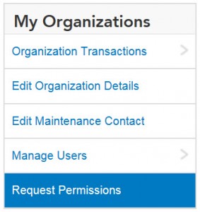
  • Requesting permissions through My Organizations > Request Permissions
  • Contacting your administrator to invite you through token-based authentication or
  • Contacting you administrator to directly connect your username.  
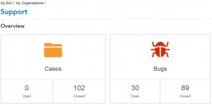
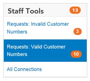
Note: You can connect to multiple organizations in My Esri; follow one of the methods above to connect to an additional organization. Get an Overview of Your Support OrganizationFor a quick snapshot of your organization’s overall support status, check out the Overview page. On this page, you can see case and bug volume, contact information, a brief overview of recent activity, and more. For further detail, visit one of the other pages: Recent Activity, Cases, Bugs, or Authorized Callers.6-21-2016-2-01-44-PM-300x148.jpgView Recent ActivityThrough the Recent Activity subtab, users can get a snapshot of recent activity, including that of bugs and cases. For a more detailed analysis, see the pages for bugs, cases, and so forth. View Case and Bug InformationFor a more in-depth look at cases and bugs beyond what’s shown on the Recent Activity page, please visit the pages for Cases and Bugs, respectively. In these views, you can apply more filters to expedite search, view a specific activity report, and see more metadata related to the bug and/or case. Become an Authorized CallerIf you wish to become an authorized caller, please contact your administrator or navigate to My Organizations > Request Permissions—this will notify the administrator to determine your permissions. As an authorized caller, you can contact Esri through the phone or through My Esri. For Administrators Manage Authorized CallersYou can use the Authorized Callers subtab to add, edit, or delete authorized callers, as well as export the list of authorized callers. If you wish to add an authorized caller who is already part of your organization, navigate to the Authorized Caller page, and click the Add Caller button to elect an authorized caller. For Distributors 6-21-2016-1-25-40-PM-300x270.jpgAccess the Staff Tools MenuAs a distributor, you can review and manage permissions requests for customers with valid or invalid customer numbers. Additionally, you can find a list of all users who are connected to the organization. Note: All international users will be labeled as invalid, as these users are not shown the customer number field when submitting a request.
  • Unless you’re a distributor on Global Support, the Support feature set in My Esri is disabled by default. Once you subscribe to Global Support, you should submit a request to the My Esri team to enable the Support feature set.  
Note: If you are an authorized caller or administrator from a distributor and you wish to request a case or initiate a chat for a child organization, a representative from that child organization must become an authorized caller.Thanks again for your patience and feedback as we tailor your online support experience on this new platform—your efforts further embolden support on My Esri! If you’d like to send us additional questions or comments about Support on My Esri, please click the feedback link found at the bottom of each page on My Esri, or leave a comment on this post.
Megan S. - Online Support Resources 

more
2 0 2,528
GregoryLehner
Esri Contributor

asp_logo.jpgASP, the Association of Support Professionals, is commonly recognized as the most reputable and non-biased technical support website evaluation and ranking organization in the industry.

In preparation for the redesign of our own support website, Esri’s Online Support Resources team has been working with the ASP for over six years, gleaning years of best practices from other award-winning technical support websites. It has been one of our team’s goals to submit our own website for this year’s competition. Our new Support website was launched last month on May 26th, and the evaluation results for the Top Ten were announced last week.

It is our pleasure to announce that this year, Esri’s technical support website has been awarded by the ASP one of 2016's Top Ten Support websites. For this competition, the ASP appoints five experienced judges, who develop and maintain support websites, to evaluate industry websites in 25 different categories. Though the ASP ranks the Top Ten technical support websites, they segment this list into three categories. Large companies (five companies with over 1 billion dollars in revenue), mid-sized companies (four companies whose revenues range from 100 million to 999 million), and small companies (one company whose revenue is under 100 million dollars).

In the "Large Company" category, Esri was ranked in the top five best websites of the year. All other award winners in this category are recognized industry leaders and household names.

Large Company (over $1 billion)- Cisco
- Dell Software- Esri
- Red Hat
- Symantec

Medium Sized Company ($100 million to $999 million)- Jive
- Blackbaud
- LANDESK
- Nutanix

Small Company (under $100 million)
- Tricentis


Award winners in previous years include Microsoft, Adobe, Intel, IBM, McAfee, HP, Juniper Networks, Oracle, Nokia, SAS, EMC, and more. Please note that all other winners in this year’s large company category are considerably larger than Esri.

We are always driven to provide our customers and partners with the best support experience possible, whether it is online, over the phone, or in person - and this is certainly another milestone along accomplishing and sustaining these goals and aspirations.

For more information about the ASP Best Web Support Sites competition, please visit their website.
Michael Kim - Director of International Support

more
0 0 626
GregoryLehner
Esri Contributor

This blog post provides the latest updates regarding deprecated features in ArcGIS 10.4 and in the recent release of ArcGIS 10.4.1.

With each release, the platforms and functionality supported in the ArcGIS platform are assessed and adjusted based on customer needs and technology trends. The purpose of the Deprecated Features for ArcGIS document is to provide as much advanced notice as possible regarding these changes.

For more information on our deprecation plans, refer to the following PDF document, Deprecated Features Plan for ArcGIS 10.4 and 10.3.x Series (this deprecation plan is also available at the following technical article in the Esri Support Knowledge Base). The documentation linked above provides additional information about each note below, in addition to recommendations of alternative workflows and applications.

Here are some of the major changes in the update for ArcGIS 10.4 and 10.4.1:

  • The ArcGIS Engine SDK for Cross-platform C++ will not be supported after ArcGIS 10.4.1.
  • ArcGIS 10.4.1 will be the last release of Engine Linux. ArcGIS 10.4.x for Engine Linux will be supported till 2022.
  • ArcGIS 10.4.1 (and ArcGIS Pro 1.3) will be the last release that supports the PostgreSQL 9.2.x series.
  • ArcGIS 10.4.1 for Server will be the last release to include support for the Mobile Content Server and Mobile Data Access features in the GIS server.
  • ArcGIS 10.5.x for Server will be the last major release series to include support for the Search Service functionality in the GIS server.
  • ArcGIS 10.2.1 for Windows Mobile is the last release. No additional features, functionality, or performance / stability updates will be released for this application.
  • ArcGIS 10.4 is the last release that supports the Oracle Spatial GeoRaster data type.


Gregory L. - Online Support Resources

more
0 0 1,255
GregoryLehner
Esri Contributor

Update, 2 June 2016: Google Chrome 51.0.2704.79 was just released; it fixes the change that caused a blank screen for ArcGIS Online, Portal for ArcGIS, and applications built with the ArcGIS API for JavaScript. If you are affected by this, please click the Customize and control Google Chrome button and navigate to "Help > About Google Chrome" to force an update check and upgrade to this latest patch level.

The previous version was 51.0.2704.63, and the fixed version is 51.0.2704.79.

Update, 27 May 2016: KB 13156 has been published on the Support website to provide additional information about this issue.

---------------------

Google released an update to Google Chrome (version 51), which was pushed out to the public on Wednesday, May 25th. Unfortunately, this update included a change that impacts anyone using Google Chrome to access ArcGIS Online or Portal for ArcGIS versions 10.3, 10.3.1, 10.4, or 10.4.1.

This change impacts many apps built on the ArcGIS API for JavaScript (versions 3.8 - 3.16), several subsets of custom apps built by users, partners, and Esri Professional Services (for example, any app that uses the feature table or an analysis widget), and, most notably, the "home app" in ArcGIS Online and Portal for ArcGIS.

You may be seeing a screen similar to this after logging in: a blank screen with few or no elements.

googlechrome51.jpg

What you can do:

If you are using Google Chrome to access ArcGIS Online, the above listed Portal for ArcGIS versions, or apps built with the above-listed versions of the ArcGIS API for JavaScript, please turn off auto-update in your Chrome browser now. If Chrome was updated, you will need to temporarily use another browser (such as Internet Explorer or Mozilla Firefox) until patches have been released.

What Esri is doing:

  • The ArcGIS Online team is preparing fixes that will go live this evening.
  • We are still working on a solution for Portal for ArcGIS.
  • Developers using the hosted version of the JavaScript API are unaffected, as it has already been patched.
  • We are working on a solution for JavaScript API developers that use either a custom build of the API or use it locally.


We will provide updates at the top of this blog post regarding Portal for ArcGIS and ArcGIS API for JavaScript as soon as we have more information. A technical article has been released for this issue, KB 13156, which provides some additional detail about this problem.

If you have run into any problems as a result of this bug that impact your workflows, please contact Esri Support Services at 1-888-377-4575.


Gregory L. - Online Support Resources

more
0 0 2,331
40 Subscribers