ArcGIS Survey123 Blog - Page 21

cancel
Showing results for 
Show  only  | Search instead for 
Did you mean: 

Latest Activity

(295 Posts)
DeonLengton
Esri Contributor

Do you want to create a break-out link from your survey to Twitter, WhatsApp, eMail etc?

Here are a few examples of how the HTML tags should look like to achieve this (just substitute your fields into the examples and paste it into a survey note field):

 Open the device's default mapping application (such as Google Maps) with the coordinates of the survey:

concat('<a href="geo:', ${Lat}, ',' , ${Long}, concat('">Display on the Map</a>'))

 Open Google Maps with driving directions to coordinates:

concat('<a href="http://maps.google.com/maps?daddr=', ${Lat}, ',' , ${Long}, concat('&amp;ll=">Directions</a>'))

 Open the device's default email application with a to email address:

concat('<a href="mailto:', ${Email},concat('">', ${Email}))

 Create a Tweet from your survey:

concat('<a href="https://twitter.com/intent/tweet?text=This tweet sent from Survey123! #ArcGIS','">Create a Tweet</a>')

 Create a WhatsApp message from your survey:

concat('<a href="whatsapp://send?text=This is a WhatsApp message from Survey123!">Create a Whatsapp message</a>')

 Open Collector with a specific web map:

${Collector_Intent} = concat('arcgis-collector://?itemID=68085fc05c401ca5716e5677a6128c')
concat('<a href="',${Collector_Intent},'">Open Collector</a>')

(first create a calculated field named Collector_Intent and then use that field in the second calculated field)

 Open a specific survey (with parameters) from Survey123:

${S123_Intent} = concat('arcgis-survey123://?itemID=887d507cee48d18ad3cdfaf9f081e6&field:Service_Rating=1')
concat('<a href="',${S123_Intent},'">Open specific survey</a>')

(first create a calculated field named S123_Intent and then use that field in the second calculated field)

 Open an SMS (with the coordinates in the body) from Survey123 (this works in Android - not tested on iOS):

concat('<a href="sms:','08212345678','?body=', ${Lat}, ',' , ${Long}, concat('">SMS</a>'))

(to get the coordinates - just use the pulldata() function)

 Open a local file (such as a PDF help file or an image located in your survey's media folder) from Survey123 - this works and has been tested on Android:

concat('<a href="file:///storage/emulated/0/ArcGIS/My Surveys/549c05bae0f14e388000486ce4de950c/esriinfo/media/Example.pdf" class="link external button button-raised button-fill color-blue">Demo</a>')

(549c05bae0f14e388000486ce4de950c will be different for each survey. It refers to the survey item id)

I will add more examples as the need arises 

more
27 43 23.1K
IsmaelChivite
Esri Notable Contributor

Do you know the difference between a dart and a glider? Well you should, because you will want to make good use of all those paper forms you no longer need. Get ready for National Paper Airplane Day, which is coming up on May 26! 

What goes through your mind while folding a piece of paper to make an airplane? What do you feel when it escapes your fingers gliding away? Paper airplanes are truly amazing. Take a moment to enjoy them, if possible with good company.

We split our 2.8 update in two. Just a few days ago we released the Survey123 field app with a critical fix for all of you using the app with public surveys. We also included a couple of additional bug fixes. For more details refer to thehttps://community.esri.com/groups/survey123/blog/2018/05/16/minor-update-to-the-survey123-field-app-... blog post.  Today, we are making available an update to our Survey123 website. It comes with some bug fixes, but also brings a few interesting new features. Here are the highlights:

Survey123 Web Designer Enhancements

Survey123 Web Designer lets you visually build your own surveys, right from your web browser. In this update, we have added features particularly useful for those of you who plan to publish surveys for exclusive use from web browsers (Web Forms).

New Single Choice Grid questions: Survey123 web designer now includes a new type of question called Single Choice Grid. This question type lets you to arrange a set of single choice questions in a table.  The only condition is that all single choice questions in the table use of the same choice list.

There are multiple scenarios where Single Choice Grids are useful.  A classic one is checklists, like the one presented below for a Fire Safety inspection.

Single Choice Grids will help you compact questions within your forms allowing users to enter data more easily.  As you add Single Choice Grid questions into your form, keep in mind the following:

  • Horizontal real estate is going to be limited, so keep the number of choices in your lists and labels short.
  • You cannot set rules against the Single Choice Grid or any of the individual questions in it.
  • If you choose to flag the grid as required, then all rows (questions) within the grid must contain an answer.
  • Single Choice Grids are only supported in Web Forms (in our Survey123 Web App). The Survey123 Field app does not currently handle this type of question. [Updated Sep 26, 2019] As of version 3.6, the field app also supports single choice grids.

Custom Thank You Notes: Thank You notes are presented right after a survey is submitted from a Web Form (from the Survey123 Web App). It is good practice to control the text presented in this dialog.  This is of course the right place to thank respondents for taking time to complete your survey, but also a great place to acknowledge sponsors of your project or direct respondents to your website, next actions etc. 

Starting with this update, we added a rich text editor widget so you can better control the look and feel of your Thank You notes. You can add links, images, define the size and color of text and more.

From within Web Designer you will be able to preview your Thank You note and also control if a link should be included to allow respondents to submit the survey again.

Geosearch for Geopoint questions at design time: Through the new geosearch widget included in geopoint questions, you can now more easily set the initial extent and zoom level of your map. This is particularly relevant for online surveys where people will submit data through a Web Form.   When your survey is open from a web browser, you cannot assume that the map will be centered automatically at the user's location, because often location services are disabled in browsers for privacy reasons.  With this new geosearch widget there is really no excuse for you to leave an initial map extent that is not relevant to your project!

Note: The geosearch widget uses the default locator configured in your ArcGIS Online organization.


Survey Collaborate Tab

Through the Collaborate tab in the Survey123 website, you control who can submit data to your surveys, and who can view their results.

Restrict Viewer Access: Through the Viewer category in the Collaborate tab, you define which Groups within your ArcGIS organization can visualize the results of your survey. We have added a new option that lets you control if access to the survey results is restricted to survey entries submitted by the logged-in user, or all results in the survey.

As the owner of a survey, this option gives you tighter control over what data can people see in your surveys. Here is a scenario where this new option will be handy:  Pretend that you have published a survey for a group of Building Inspectors. Through Collaborate/Submitter you have already granted them access to your survey, so all Building Inspectors are happily submitting their work to you.   Next, you would also like Building Inspectors to have access to their own submitted data through the Survey123 website.   Through Collaborate/Viewer you will next grant the Inspectors Group with access to the results of the survey, but since you do not want inspectors to see someone else's  work, you will grant visibility to 'Only their own submitted records'.   At that moment, inspectors can log into the Survey123 website and access their own records. For example, they can use the Data tab in the Survey123 website to export all their inspection data into Excel, generate high quality printable reports of their inspection records or even look at trends across their own inspections through the Analyze tab. Administrators of the ArcGIS organization and owners of the survey will always have access to all records.

Shortened survey URL links (ArcGIS Online only): If working against ArcGIS Online, the next time you share a survey URL with someone or include it into a website or e-mail, you will note that the Survey123 website will shorten them for you.  The animation below shows the difference between the shortened and original URLs.

We feel like shortened URLs are easier for most people, but if you are a nostalgic, purist or you simply want the original URL, all you need to do is to copy the shortened URL into a web browser and navigate to it. You will see that the shortened URL is simply a shortcut that gets redirected to the source (and long) URL of your survey.

Survey Analyze and Data Tabs

Photo Galleries in the Analyze report:  Up until now, Image and Signature questions in your survey were not  included in the Analyze report. Starting with this update, photo galleries will be used to display data submitted into Image and Signature questions.

The new galleries will let you more quickly scan large collections of photos submitted to your survey and if needed, by clicking on them, get more details on the photo itself.

Sort surveys by date in the Data tab table: The Data tab shows your survey results as a map and a table. Some of you suggested that data in the table should show the newest surveys on top by default. We think this is a good idea too, so rows are now sorted by the Edit Date column, in descending order. If you would like to sort using a different column, all you need to do is to click on the column header and set your sorting preference. 

Barcode question support in Individual Response reports (Data tab): The individual response report shown when you select a record from the survey table now supports Barcode questions as well, which are treated similarly to Text questions.

Survey Gallery

Launch Connect directly from the survey gallery: You can now easily launch Survey123 Connect from the survey gallery to make updates and re-publish your Connect surveys. This option will only work if you have Survey123 Connect 2.7 or newer.  I trust you will have Connect in its latest release. Right?  You would actually not believe how many people out there are still running 1.x versions of Connect!

Major Bug Fixes and Enhancements

Survey123 Web Form (aka Survey123 Web App):

  • BUG-000108086 Field values are missing in questions within repeats (Web Form)
  • BUG-000109787 Pulldata caculations within a repeat do not update note questions if the survey is open from a web browser.
  • BUG-000108785 The message "Surveys published by Survey123 Connect for ArcGIS are currently not supported" appears when attempting to open a survey published with Connect from a web browser, if the hosting portal is configured with Integrated Windows Authentication.

Survey123 website:

  • BUG-000113180 Unable to share a survey with a group when the user is a group manager of that group in ArcGIS Online and the group setting 'who can contribute' is set to 'Only group owner and managers'
  • BUG-000113270 With Portal 10.5.1 configured with IWA, surveys published using Survey123 Connect do not show data for users in https://survey123.arcgis.com
  • BUG-000113054 The data tab of the survey123.arcgis.com website does not have appropriate logic to prevent attempting to export data that comes directly from ArcGIS Server
  • BUG-000107294 Incorrect German translation of "Please input a number less than xx".
  • BUG-000113741 When deleting a survey that is created from an existing feature service in Portal for ArcGIS, the behavior is different between Survey123 Connect for ArcGIS and the Survey123 for ArcGIS website
  • Static content in the Survey123 web site is delivered leveraging Content Delivery Network Services to reduce loading times. This will be particularly noticeable outside the United States.

Survey123 field app and Connect:

  • Regression on Public Surveys: Our 2.7 release introduced an issue that prevented the use of Public Surveys if no user was logged into the Survey123 field app. This is now addressed, allowing the use of Public Surveys in the field app even if there  is no user logged-in. Thanks to all of you who promptly reported this problem and helped diagnose it through this GeoNet Group.
  • Check for offline conditions on Windows: This update includes a fix that enhances Survey123's ability to detect if your device is connected or not, when working on Windows. We have observed some reports of Survey123 on Windows not detecting offline conditions when working on very specific network configurations. The offline check is much better now.
  • BUG-000107663 Features do not display in webmap after submission by the field app: Some of you have reported that ArcGIS Online Web Maps with a refresh interval set, were not automatically showing new features added from the Survey123 field app.  The problem was caused by a combination of issues in both ArcGIS Online feature services and the Survey123 field app. All problems are solved now!

An Archive of What's new in Survey123—Survey123 for ArcGIS | ArcGIS is available in our product help documentation.

Beyond 2.8


Our next major release will be 3.0, which we envision shipping around July 2018.   If needed, we may squeeze in 2.9 as a maintenance release with critical fixes. Here is what we are planning for our next updates:


  • Custom Form Reports: Our Leveraging Custom Form Report Templates in Survey123 for ArcGIS blog post  anticipated this feature, which is currently available to all of you in Beta.  We are working hard to move this feature into general release and incorporate into it bulk report capabilities.
  • Support for nested repeats: This feature is available for testing already through our Early Adopter Program and allows you to author surveys that have repeats within repeats. This will be part of our 3.0 release in July.
  • Enhanced support for external GNSS receivers: At the moment, you can use external GNSS receivers with Survey123, but only in a limited way. For example, you cannot extract key metadata from the receiver such as  VDOP, HDOP, Number of Satellites or the Fix Type...  With the 3.0 update our intent is to extend the pulldata() function so you can also extract this important metadata and store it along with the features you capture.  We also plan to provide support for RTK corrections. We are working towards having this feature available for testing in our Early Adopter Program around June around July, but will not be part of 3.0.
  • Webhook integration: An earlier post Sneak Peek: Survey123 and Webhooks (Integromat) described this work in more detail. Available for testing today through the Early Adopter Program.  Planned for our 3.0 release.
  • GeoSearch in the Survey123 field app map widget: Check out this video in our Early Adopter Program for details. Available for testing now and planned to be part of 3.0.
  • Support for Web Maps, Vector Tiles and Mobile Map Packages: This is  a big deal as it will make maps for geopoint questions much better looking, useful and lightweight.  Looking at having this available for testing around June. Postponed until later in 2018.
  • Pages: While Pages are not officially supported yet, we continue working on improving this feature.  Starting with 2.7 you will notice that the page navigation has been vastly improved, although there are multiple areas that still need more work before we can call it 'ready'.  If you are into pages, do not hesitate providing your feedback via the Beta forum in our Early Adopter Program.
  • Portal support: As of version 3.0 of Survey123 for ArcGIS, we will no longer support working against version 10.3.1 or older of Portal for ArcGIS.
  • iOS support: Following Apple's announcement regarding end of  support for 32 bit devices starting with iOS 11, our 3.0 release will also drop support for 32 bit devices.  Having said this, we understand that many of you still have not, or don't  plan to upgrade your Apple devices in the short term. Therefore we will make available a 32bit compatible version of Survey123 in the Apple store for a period of time to assist you with your transition. We will be naming this 32-bit compatible version of the app, Survey123 Classic and it will include only 2.8 functionality.
  • Android support: The minimum version of the Android operating system with Survey123 3.0 will be 4.4.   The Classic flavor of Survey123 will support Android back to 4.1, but will only include 2.8 functionality.


A lot in the plate as  you can see for 3.0. Our focus however it is not going to deviate from listening carefully to all your feedback through this GeoNet Group, so keep your questions and suggestions coming!

more
12 12 5,108
IsmaelChivite
Esri Notable Contributor

Here we are once again, so close to the Esri User Conference!  Below is a list of the many places where you will be able to learn more about Survey123 for ArcGIS while in San Diego.

The Esri Events App:

If you are coming to San Diego, I recommend that you download the Esri Events app. It  will help you create your own schedule and keep track of last minute changes to sessions. You can download the app from the Apple and Google Play stores.

Technical Sessions:

Technical Sessions are one UC's favorites. Always well attended, Tech Sessions run for about 60 minutes and cover technical aspects of Esri products.  We always try to keep a good chunk of time at the end for a live question & answer section. Tech Sessions start on Tuesday morning and run until Friday.  They all take place in the second floor of the San Diego Convention Center (also known as SDCC).

  • Survey123: An introduction: This session covers the basics of the Survey123 website, including designing smart forms with Web Designer, publishing and sharing surveys, generating high quality reports for submitted data and other capabilities available through the Survey123 website. The session will end with a sneak peak of smart form capabilities going beyond what is possible through Web Designer.  I recommend attending this session even if you are already familiar with Survey123, because there are many new things that have been added to the Survey123 website in the past few months.  Philip Wilson, Brandon Armstrong and Derek Law will be presenting this session, and there is always tons to learn from them!
    • Tuesday, July 10 10:00 am - 11:00 am SDCC - Ballroom 06 D
    • Tuesday, July 10 1:00 pm - 2:00 pm SDCC - Room 32 A/B
    • Wednesday, July 11 4:00 pm - 5:00 pm SDCC - Ballroom 06 F
  • Survey123 for ArcGIS: Creating Smart Forms Using XLSForms and Survey123 Connect: Join this session for an introduction to designing smart forms following the XLSForm specification with Survey123 Connect.  With Connect and XLSForms you can create the most sophisticated smart forms for the Survey123 native or web apps.  If you want to become a Survey123 Ninja you really need to make it to this session. James Tedrick and Jonathan Hasthorpe will take care of this one. 
    • Wednesday, July 11 2:30 pm - 3:30 pm SDCC - Room 09
  • Survey123 for ArcGIS: Advanced Topics: This session will introduce advanced workflows with Survey123 including editing existing features and designing surveys on top of existing feature layers, workflow automation with Survey123 and web hooks, working with external sensors in Survey123 and other exciting features. There will be lots of live demos and time for live questions.  Ismael Chivite, Elvin Slavik and James Tedrick will present this session.
    • Thursday, July 12 2:30 pm - 3:30 pmSDCC - Room 05 A
  • ArcGIS Apps for the Field: An Introduction: In this session we will describe how all ArcGIS mobile apps work together. A great place to learn how Survey123 works along with Workforce for ArcGIS, Navigator for ArcGIS, Collector and even Operations Dashboard for ArcGIS.  Scheduled presenters include Chris Lesueur, Ismael Chivite and Jeff Shaner. 
    • Friday.Tuesday, July 10 10:00 am - 11:00 amSDCC - Ballroom 06 C
    • Wednesday, July 11 1:00 pm - 2:00 pmSDCC - Room 31 C
    • Friday, July 13 9:00 am - 10:00 amSDCC - Ballroom 06 F

Survey123 User Group Meeting

We are happy to announce that this year we will have our own Survey123 User Group Meeting. It runs on Tuesday at lunch time from 11:30 AM to 12:30 PM, but no lunch is provided. This is for the ones with a strong Survey123 spirit!  Our User Group will be a great opportunity to meet other Survey123 Ninjas. This is fundamentally about connecting with other people and the team.  We will have a couple of 7-minute lighting talks to warm-up and then the rest of the time is for group discussion and networking.

Survey123 User Group Meeting: Tuesday 10,  11:30 AM - 12:30 PM  SDCC - Ballroom 06 D

Demo Theaters

You can think of Demo Theaters as mini-Tech Sessions. They are shorter, always focused on very specific workflows and run in a small setting were questions can be handled throughout the presentation.  The Demo Theaters take place in Expo area (first floor), close to the Product Islands.

User Presentations

User Presentations are a great way to learn the details of how Survey123 is applied to specific workflows. A good opportunity to learn directly from users like you!

Expo

The Expo area is opens Tuesday and closes on Thursday afternoon. It is located in the first floor in the San Diego Convention Center (SDCC) and features different areas including Partner Exhibits, Esri Industry Neighborhoods, GIS Product Areas and Customer Care booths.

  • Product Areas (Islands) at the Expo:  You will always find someone from the Survey123 team in there. This is the place to go when you want to have a one on one conversation to address specific ideas or issues you may have. We often refer to the Product Areas as Islands. The Survey123 team will have a station under a big sign that says 'Apps'. It will be a big sign... you will see it.
  • Partner & Sponsor Exhibits: The Survey123 software is only a third of the story. There are two good reasons to visit the Esri Partner and Sponsor Exhibits. The first one is that many of them are now experts building smart forms with Survey123 and know the tricks of the trade when implementing solutions. Swing by their booth and ask them about their own experience.  The second one is that through the Partner Exhibits you will find many hardware vendors that can teach you the benefits of using their offerings with Survey123. Think Laser Measurement Solutions, GNSS receivers, ruggerized devices and much more. Just to name a few:
  • Customer Care and Esri Tech Support: Our Esri Customer Care and Technical Support teams will be represented in the Expo. You can also swing by their stands with your Survey123 technical questions.
  • Esri Industry Neighborhoods: Everything from Public Safety to Defense, Local Government, Utilities and more.  The Industry Neighborhoods are a good place when you want to connect with people that understands how to put Survey123 in the context of your own workflows.  Ask for a demonstration of Survey123 focused on your problem or for examples of organizations using Survey123 in your industry.

Esri Education Summit

The Esri Education Summit takes place between July 7-10 at the Marriott Marquis & Marina Hotel. You will need to register separately for this one!


Pre-Conference Seminars

By now, many Pre-Conference Seminars are sold-out, but I thought I would include info about this for those of you who are planning to come next year. You need to hurry before all seats are  taken.  Survey123 will be highlighted in the Field Operations and ArcGIS PreConference seminar:

  • Field Operations and ArcGIS
    • A full day hands-on seminar covering the complete suite of ArcGIS apps: Workforce, Navigator, Survey123, Collector and Operations Dashboard.
      • Sunday, July 08 8:30 am - 5:00 pm


more
5 1 1,651
IsmaelChivite
Esri Notable Contributor

A minor update to the Survey123 field app has been made available in the Apple, Google Play and Amazon app stores.  If you happen to use the Survey123 field app on your laptop or desktop computer, the setups are also available for Windows, Mac and Linux.

The build number for the Survey123 field app and Connect is now 2.8

This release includes a handful of critical fixes:

  • Regression on Public Surveys: Our 2.7 release introduced an issue that prevented the use of Public Surveys if no user was logged into the Survey123 field app. This is now addressed, allowing the use of Public Surveys in the field app even if there  is no user logged-in. Thanks to all of you who promptly reported this problem and helped diagnose it through this GeoNet Group.
  • Check for offline conditions on Windows: This update includes a fix that enhances Survey123's ability to detect if your device is connected or not, when working on Windows. We have observed some reports of Survey123 on Windows not detecting offline/online conditions when working on very specific network configurations. The offline/online check is much better now.
  • BUG-000107663 Features do not display in webmap after submission by the field app: Some of you have reported that ArcGIS Online Web Maps with a refresh interval set, were not automatically showing new features added from the Survey123 field app.  The problem was caused by a combination of issues in both ArcGIS Online feature services and the Survey123 field app. All problems are solved now!

We plan on updating the Survey123 website in the next couple of weeks, bringing a handful of enhancements and fixes. Stay tuned.

more
7 11 2,939
RogerMesen-Delgado
Frequent Contributor

There is a way to invoke #Survey123 with the fields fill. With the URL. if you want to know more about how to configure the URL is better to check the following link (click here). In the blog Ismael Chivite  explain deeply how to use the url. 

This blog is more about how to transform the link in a button to show a better graphic interface to the user.

Basically when you have the link with the url of the form and you are setting the pop-up you can configure a "kind of button", with the following #html code.

<font size="5">

<a href="arcgis-survey123://?itemID=xxxxxxxxxxxxxxxxxxxx" style="display: inline-block; outline: none; cursor: pointer; text-align: center; font-style: normal; font-variant: normal; font-weight: normal; font-stretch: normal; line-height: 100%; font-family: Arial, Helvetica, sans-serif; padding: 0.5em 0.8em 0.55em; text-shadow: rgba(0, 0, 0, 0.3) 0px 1px 1px; border-radius: 0.5em; box-shadow: rgba(0, 0, 0, 0.2) 0px 1px 2px; text-decoration: none; color: rgb(255, 255, 255) !important; background: rgb(17, 127, 170) !important;">Orden de Trabajo</a> <br /><div style="text-align: center;"> </div>

</font>

this code shows up the following button in collector or workforce. Depending of the pop up that you set.

As you can see is a better interface that a link for the user. I you need more information just let me know in the comments. 

more
6 4 4,111
RogerMesen-Delgado
Frequent Contributor

In this case I been working in one survey for a local government in Costa Rica. They need the total time that the user spend doing the survey. So I Create a start and end type of fields(important: do not use the default values of now() ) Those kind of fields automatically generate the values. The time Start create the same value of the #now(), but the end is fill at the end of the #survey. Check the image. After create the start and end field you create the #calculation field with the following #formula 

/*

round(int(${Hora_Fin} - ${Hora_Inicio}) div (1000*60),0)

*/

This field is going to update automatically.

Enjoy creating forms and tell me if it works for your form. 

more
3 1 837
JaysonWard
Occasional Contributor

For this blog post, and the subsequent blog post on extending Survey123's functionality, I've created a user story for a fictitious municipality called the City of Cilantro that will help guide the customization process. Also, a public repo with the customized app is available at Github: Cilantro Surveys 

I. User Story

The City of Cilantro needs a custom version of Survey123 that will be used by various city departments to conduct public and private surveys. The city currently has three customization needs:

  1. The app needs to be branded to match the organization. [Not extending core functionality]
  2. The city needs the ability to print the time and location onto new photos taken with some surveys. [Extending core functionality]
  3. Some surveys used in the field will include the scanning of barcodes as the only action required of the survey. The application will need to automatically submit the survey after the barcode is successfully scanned and then open a new survey immediately upon successfully submitting the previous survey. [Extending core functionality]
 
This blog post will address the first customization need. Updating the user interface (UI) to match an organization's branding doesn't affect or amend the application's core functionality and requires no coding experience (there is one caveat to this currently which is noted in section III.4). Let's first look at the asset's needed to create the custom look and feel before downloading the template.

II. Assets & Information Needed

a. App Name

Cilantro Surveys
The app should have a distinct name. It should not be called Survey123. For the City of Cilantro, 'Cilantro Surveys' was chosen as it referenced the city's name and also kept the name simple and succinct.

b. Branding Color

#543e36
The Survey123 application has one main color used throughout the UI that 'brands' the look and feel. Survey123's branding is built around a hue of green, and can be seen throughout the UI of the application as well as the website and associated marketing materials. When customizing Survey123, it is highly recommended that a different color be used in order to help distinguish the app from Esri's production version of Survey123. The color should ideally match the branding guidelines and needs of the organization that is customizing the app. The City of Cilantro uses a brown hue in their logo, so that same hue of #543e36 will be used in the custom app.

c. App Icon

The app icon is what the user will see in the device's user interface and will be touched or clicked to open the app.
  • 512 × 512 (pixels)
  • .png file

d. Launch Screen Image Overlay

The launch screen overlay is a graphic that will appear above a colored background when the app is launched into the device's memory. 
  • 768 × 768 (pixels)
  • .png file
  • Should include transparency or the background color should match the color set for the background color in the app's settings. In this example the image includes white graphics on a transparent background. The background color is set to #543e36 in app's settings.

e. App Thumbnail [for ArcGIS only]

The app thumbnail is used to help distinguish the app in ArcGIS galleries. It is used throughout the web and AppStudio to visually reference the application item.
  • 200 × 133 (pixels)
  • .jpg or .png file

f. Company / Organization Logo [optional]

The company / organization logo is an optional asset. If included, it will appear on the app's About view. It can additionally be set to open a custom url to an external website.
  • Height should be a maximum of 200px. The width will be automatically adjusted to preserve the image's aspect ratio and fit the logo into horizontal space on the About view.
  • .png or .jpg file

g. Custom Font [optional]

The Survey123 template allows for the use of a TrueType font family in the customized application.
  • .ttf (TrueType) files supported.
  • Ensure that the font is licensed or has a license that allows it to be distributed with the app.
  • For the Cilantro Surveys app, we are using the Raleway font family available from Google Fonts, which has an Open Font License.

III. Steps to UI Customization

Now that I've outlined the assets and information needed to create a custom version of Survey123, the next step is to download the template and get started. I'll go through this step by step and reference the assets and information listed above along the way.

1. Download the template

  1. Open AppStudio for ArcGIS. You don't have to log into your ArcGIS organizational account in order to download the template, but it is a best practice. 
  2. Click "New App"
  3. Click the "Enterprise" tab in the New App dialog
  4. Select Survey123 (Template), enter the title of the app ("Cilantro Surveys" in this example) and click "Create"
  5. The new app template will download and appear in the AppStudio gallery.

2. [Optional] Create the fonts folder and add the font files

This step is only required if you are using a custom font family.

  1. Right-click the gallery card for the app in AppStudio and select Open in folder.
  2. Open the "Controls" folder
  3. If the folder doesn't contain a "fonts" folder, create one. 
  4. Copy all of your .ttf files into that folder. 
    • In this example we'll be copying the Raleway fonts to the folder.

3. Update the app's settings and assets

Now comes the most significant step where the assets and settings for the app are updated.

  1. Make sure the gallery item for the downloaded template is selected and then open Settings for the app. This can be down by right-clicking on the gallery item and clicking Settings from the menu, or using the side menu. 
  2.  Details Tab
    1. First update the app's details under the Details tab.
    2. Click the thumbnail and replace it with the app thumbnail created for the app (See section II.e)
    3. Update the app's summary, description and access use and constraints to reflect the new app. The description will appear in the app's About view.
  3. Survey123 Tab
    • General Tab
      • Text color: The text color used in all non-title text in the app. I'll leave this set to the default value of #4c4c4c.
      • Background color: This will set the background color displayed in the gallery and the survey info views. I'll leave this set to the default of #efeeef.
      • Title bar text color: This sets the foreground (text) and icon colors for the top bar in the gallery and survey info views. I'll leave this set to the default of #ffffff. Because the branding and background color for Cilantro Surveys is dark, the white text will contrast well against it.
      • Title bar background color: The background color used in the app's title bars.
        • For Cilantro Surveys I am using the branding color of #543e36 (see section II.b).
      • Font Family: This is where the name of the custom font is entered. For Cilantro Surveys I am using the Raleway font family.
        • Note: The text entered here would be the same text entered for the css font-family property if the font were being used on the web (e.g. font-family: 'Raleway';)
    • Other Properties
      • backgroundTextureImage: This property is no longer used.
      • companyLogo: The company logo that appears on the app's About page (see section II.f). 
      • companyUrl: URL opened via the company logo on the About page.
      • formBackgroundColor: The default background color used for forms in the app.
      • startBackgroundColor: The background color of the opening splash screen.
        • For Cilantro Surveys I am using the branding color of #543e36 (see section II.b).
      • startForegroundColor: The foreground color of the opening splash screen.
      • startOverlayImage: The image that appears on the opening splash screen.
        • For Cilantro Surveys I'll set this to our company logo as well (see setion II.f).
  4. Resources Tab
    • App Icon
      • I'll set this to the icon created with the assets (see section II.c)
    • Launch Image
      • Overlay image: I'll set this to the launch image created with the assets (see section II.d).
      • Background Image: I won't use this property with the customized app.
      • Background color: I am using the branding color of #543e36 (see section II.b).

4. Fix small bug in code [only for templates based on version 2.7 or less]

Survey123 templates based on version 2.7 of the app or less have a small bug in the code that needs to be fixed in order for the branding color to be reflected on the survey view. To fix the bug do the following:

  1. Open the app codebase in Qt Creator. This can be done by right-clicking on the app card in AppStudio and selecting "Edit in Qt Creator" or by highlighting the app in the AppStudio gallery and clicking the "Edit" button in the side panel.
  2. Open the following file by using the file browser in the left panel of Qt Creator: template > SurveyView.qml
  3. Within the style property of the XForm component in SurveyView (approximately line 501), add the following 2 properties below the line:  fontFamily:app.fontFamily
    titleBackgroundColor: app.titleBarBackgroundColor
    titleTextColor: app.titleBarTextColor
  4. You can view the code in the Cilantro Survey's public repo at CilantroSurveys/SurveyView.qml 
  5. Save the file and close Qt Creator.

5. Upload the app

Upload the app to ArcGIS online. This will allow you to register a client id for the app so that it can use OAuth for login authentication, as well as provide access to CloudMake.

6. Register the client id in order to use OAuth

In order for users to be able to log in to your app with their ArcGIS Online or Portal credentials, a client id must be registered for the app. If the app is located on ArcGIS Online, registering the client id is an easy process*.

  1. Open Settings for the app (see Step 3.1 above). 
  2. Click the Advanced button on the bottom bar next to Apply.
  3. Under ArcGIS Client ID click the "Register" button (You must be logged in to ArcGIS Online). 
  4. Settings will register the app with ArcGIS and return a client id that will appear in the text field.
  5. Once the client id is returned and visible, click "Apply".
  6. That's all

*Note:  If the app needs to authenticate to a Portal for ArcGIS, you will need to follow instructions similar to those outlined in this article (substitute your app's name for Survey123 in the article).

7. Test and Build app

Now the only thing left to do is build the app. Before doing that, most of the changes made in the previous steps can be previewed in AppRun or AppStudio Player.

  • To open the app in AppRun either double-click the app card in the AppStudio gallery or click "Run" in the AppStudio side panel.
  • For more information on AppStudio Player, see: Guided tour—AppStudio for ArcGIS | ArcGIS 

Building the app via CloudMake or Local Make is beyond the scope of this blog post. However, please note that in order to build the app for various platforms appropriate developer certificates and provisioning profiles are required.

That's all there is for white label branding Survey123. However, if you want to finesse the app's look and feel even further, feel free to jump into the code .

more
6 11 10.7K
IsmaelChivite
Esri Notable Contributor

On 8 December 2005, the General Assembly declared that 4 April of each year shall be observed as the International Day for Mine Awareness and Assistance in Mine Action.

It called for continued efforts by States, with the assistance of the United Nations and relevant organizations, to foster the establishment and development of national mine-action capacities in countries where mines and explosive remnants of war constitute a serious threat to the safety, health and lives of the civilian population, or an impediment to social and economic development at the national and local levels.

The Geneva International Centre for Humanitarian Demining has leveraged Survey123 for ArcGIS over the last year and a half to capture the location of reported explosive devices, record hazardous areas and interview and support victims and survivors. We devote this update to GICHD and to all organizations committed to make a difference for those who suffer the long lasting consequences of war.

To learn more about GIHCD and their work with Survey123, watch this video:

Next, lets describe the highlights for this update:

Web Designer Enhancements

Starting with this release, you can add signature questions into your surveys, right from Web Designer.

Signature questions are supported in both Web Forms as well as the Survey123 field app and present to the end user a simple black-over-white signature pad.

Signatures are stored as attachments, like other images.

Rules: Rules in Web Designer allow you to define simple conditional statements to control the visibility of questions in your form. Using rules, you can dramatically simplify your forms, ensuring that users are only presented questions relevant to them.  To define a rule, you need to first select a question of type Single Choice, Dropdown, Likert or Rating. At that point, the Set Rule option will be enabled so you can define what questions will be shown when a particular choice or rating is selected. Up until this update, rules were only supported in Web Designer for single choice questions.

Autocomplete: You can now enable autocomplete on questions of type dropdown.  This is particularly useful when working with long choice lists.

Compact choice lists: A new 'horizontal compact' appearance has been added to single and multiple choice questions. Use this appearance if you want the choices to be arranged horizontally, but preserving as much space as possible.

Date questions: Date questions have been enhanced in Web Designer so you can control if the calendar control should let users define a complete date (Year, Month and Day), or simply the year or the year and the month.

Bug fixes and other enhancements:

  • ENH-000111156: Add support for pulldata() in geopoints in the Survey123 Web Form
  • BUG-000111357: Clicking the collaborate option for a survey in the Survey123.arcgis.com website returns an error, "Survey does not exists or is inaccessible" when labels are kept empty in the corresponding survey form.
  • BUG-000111377: Trying to publish a form using the Survey123 site containing multiple choices, with a choice containing more than 32 characters, fails to publish the survey and results in the error, "Unable to publish the survey. Length >32"
  • BUG-000111206: hide-input appearance does not work when taking the survey in the web app
  • Multiple issues addressed when using Web Forms in IE11 Web Browser.

Survey123 Field App and Connect

Version 2.7 of the Survey123 field app and Connect does not come with major new functionality, but it is loaded with many fixes and enhancements. Lets start with a selection of critical fixes:

  • BUG-000096762: Feature Services published from Survey123 Connect for ArcGIS do not define a "Display Field" in the feature layer rest endpoint. This bug prevented surveys published from Survey123 Connect from working within Collector for ArcGIS Android. It also caused table preview issues in some versions of Portal for ArcGIS.
  • BUG-000108943 Required values for integer, decimal, geopoint, and DateTime questions in a Repeat section can be submitted blank. Also raised by Johan Ekenstedt in GeoNet: Required geopoints in repeats doesn´t work 
  • BUG-000110669: This bug caused the form not to center the screen on empty required questions after validation, making it difficult for end users to identify which required questions had been left empty. Also raised in GeoNet: Survey123 2.0 Change Question 
  • BUG-000109967:  Offline maps not available in the Inbox, Sent and Outbox. Now fixed in this release. Also raised in GeoNet: How to use TPK on Inbox map? 
  • BUG-000108975: When previewing a survey in Survey123 Connect for ArcGIS, validating the input for the first selection in a cascading select will not function as desired. Fixed!
  • BUG-000110311 In iOS operating system, copying sent data to a new survey and deleting an attachment results in the attachment missing from subsequent copy from sent. Addressed.
  • BUG-000106661 Updating a sent survey that is connected to a feature service from the ArcGIS Server that is federated with Portal (not hosted) will result in the following error: Unable to Complete Operation. Error code 400. Fixed.
  • Fix-Heather Follis: This fix accommodates cases where the Sent box could not display submission error messages. More details at: Our completed surveys are not sending. They stay in outbox with red exclamation and no errors. 
  • Fix-John Walls: A fix to address situations where certain surveys would cause Survey123 Connect to crash.More details here: Survey123 Connect Crashing When Opening Survey  Thanks John for reporting.
  • Fix-Chris Shuck: With this fix, a survey can include multiple expressions extracting EXIF metadata from images. More details at Pulldata function on multiple photos freezes the app
  • Fix-Eric Page: With this fix, the Inbox now properly displays and sorts Inbox records based on submission time, when the Inbox makes use of a query. Survey123 Inbox Sorting and Filtering 
  • Fix-David Rebot: Great find by David: Default values were not being applied if the autocomplete appearance was in use. Addressed in this release. ISSUE with Autocomplete interfering with Defaulting Date/Time fields 
  • Fix-Shane Clark: This one was an oldie that we had to accommodate. Input masks now no longer make your questions required. body::esri:inputMask should not require input   Shane: your finding was a good one too...

And here a list of the most relevant enhancements in the Survey123 field app and Connect:

  • Enhancements to annotate appearance: We introduced smart sketching in our 2.4 release and many of you are leveraging it today. In this update we incorporate two popular requests:
    1. Allow end users to sketch on top of existing images from the photo gallery
    2. Allow end users to rotate images before sketching
  • Optionally disable Web Form generation in Connect: A new option has been added in the Publish dialog in Connect so you can disable the Web Form generation. This is handy when you have lists with many thousands of choices in your XLSForm.
  • UTC offset property: ArcGIS Hosted Feature Services store date and time information in UTC. This causes issues in some applications (like ArcMap) that are not UTC-aware, when people work across multiple time-zones. To compensate for this, we have extended the pulldata function so you can store the UTC-Offset of the device from which the data is being submitted as a GIS attribute. The syntax is as follows: pulldata("@property", 'utcoffset').
  • Calculate select_ones: Last but not least, you can now calculate values in select_one questions.  That is, you can trigger a selection on a select_one question from a calculation. There have been multiple threads on this in GeoNet including: Criteria / Calculation Based Select_One Auto-Population , Pre-populate Select One/Select Multiple fields from CSV , Auto-Populate Select One Question Based on a Previous Select One Question  and default depending on previous answer
  • Go to the top of a repeat on new record: Did you ever feel like you were stuck at the bottom of a repeat when adding a new record? Did you ever feel like you wanted to be taken back to the top?  Well... 2.7 does it now for you! Thanks to all of your feedback on this one too:Have a new repeat scroll to top , Adding record in repeat stays at bottom of group. , Have a new repeat scroll to top.

If you are a developer building your own version of Survey123, you can also now download the latest code from AppStudio for ArcGIS.

Beyond 2.7

Looking at next steps beyond 2.7, we have already a handful of projects that have made sufficient progress as to be shared in a near-term road map. Our next major release will be 3.0, which we envision shipping around July 2018.   If needed, we may squeeze 2.8 and 2.9 as maintenance releases with critical fixes, but 3.0 in July will be the update with the most relevant new features, of which I want to highlight:

  • Custom Form Reports: Our https://community.esri.com/groups/survey123/blog/2017/07/26/introducing-custom-form-report-templates... blog post  anticipated this feature, which is currently available to all of you in Beta.  We are working hard to move this feature into general release and incorporate into it bulk report capabilities.
  • Support for nested repeats: This feature is available for testing already through our Early Adopter Program and allow you to author surveys that have repeats within repeats.
  • Enhanced support for external GNSS receivers: At the moment, you can use external GNSS receivers with Survey123, but only in a limited way. For example, you cannot extract key metadata from the receiver such as  VDOP, HDOP, Number of Satellites or the Fix Type...  With the 3.0 update our intent is to extend the pulldata() function so you can also extract this important metadata and store it along with the features you capture.  We also plan to provide support for RTK corrections. We are working towards having this feature available for testing in our Early Adopter Program around June.
  • Webhook integration: An earlier post https://community.esri.com/groups/survey123/blog/2018/03/05/sneak-peek-survey123-and-webhooks-integr... described this work in more detail. Available for testing today through the Early Adopter Program.
  • GeoSearch in the Survey123 field app map widget: Check out this video in our Early Adopter Program for details. Available for testing now.
  • Support for Web Maps, Vector Tiles and Mobile Map Packages: This is  a big deal as it will make maps for geopoint questions much better looking, useful and lightweight.  Looking at having this available for testing around June.
  • Pages: While Pages are not officially supported yet, we continue working on improving this feature.  Starting with 2.7 you will notice that the page navigation has been vastly improved, although there are multiple areas that still need more work before we can call it 'ready'.  If you are into pages, do not hesitate providing your feedback via the Beta forum in our Early Adopter Program.

A lot in the plate as  you can see for 3.0. Our focus however it is not going to deviate from listening carefully to all your feedback through this GeoNet Group, so keep your questions and suggestions coming!

There are many other ideas in our backlog including survey pages, support for polygons and lines, on-premises setup of all components of Survey123 and many other enhancements which remain as high priority in our list, but will see the light after the 3.0 release.

more
16 12 6,539
MarkBockenhauer
Esri Regular Contributor

In this article we will learn how to launch Survey123 from Explorer for ArcGIS and pass attribute information from the Explorer map to the survey.  For this example we will use a map of Shenandoah National Park that that will allow hikers to provide trail information for their current location by launching a survey.

Here is a video that shows the scenario:

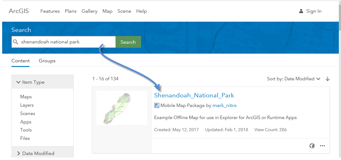
In this exercise we will use an offline map for Shenandoah National Park.  We will create a Survey for Survey123 that will allow map users (park visitors) to submit trail reports. 

If you are brand new to using ArcGIS Pro, I would recommend working through the Using ArcGIS Pro to make an offline map blog https://community.esri.com/community/gis/applications/arcgis-pro/blog/2018/01/20/use-arcgis-pro-21-t..., which walks through each step in creating an offline map.

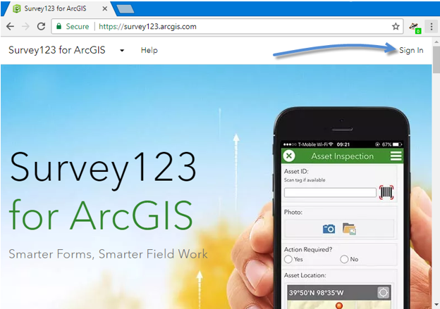
We will start by creating a Survey.  For this step you will need an Esri user account.  In a web-browser visit https://survey123.arcgis.com/ and sign in.

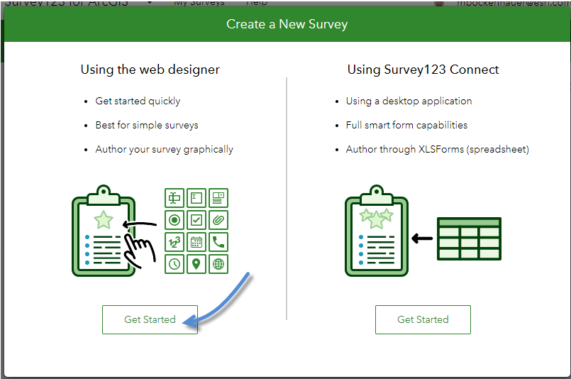
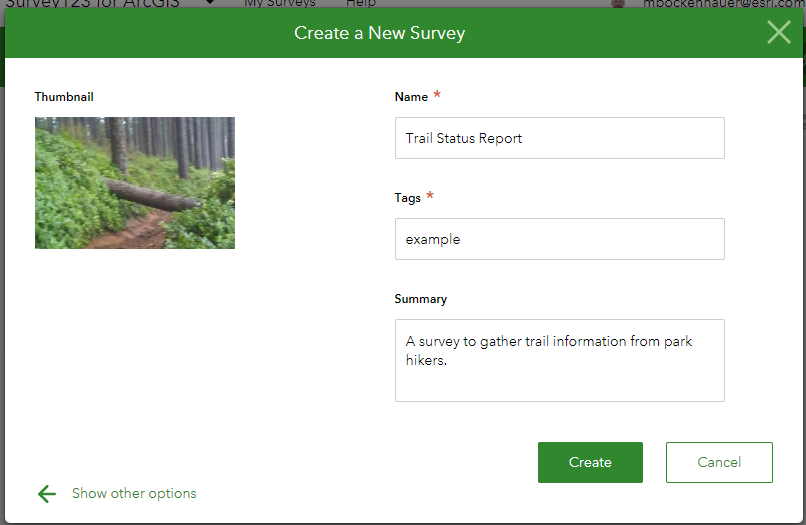
Click “Create a New Survey”

For this Survey we will get started using the Web Designer.

Enter name, tag, summary and provide a thumbnail for your survey… then click create.

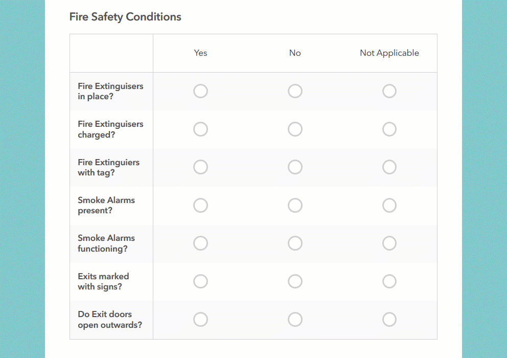
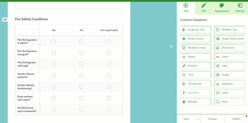
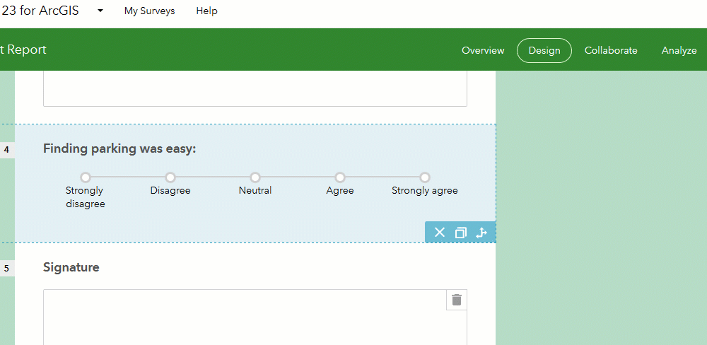
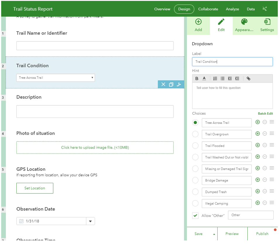
Use Survey123 to build your survey.  For this survey we want hikers to provide trail information, so we will set up the Survey with some common trail issues that we want to know about, as well description, photo, location, and observation time.

If you are new to working with Survey123 web designer, check out this video  https://survey123.arcgis.com/videos/

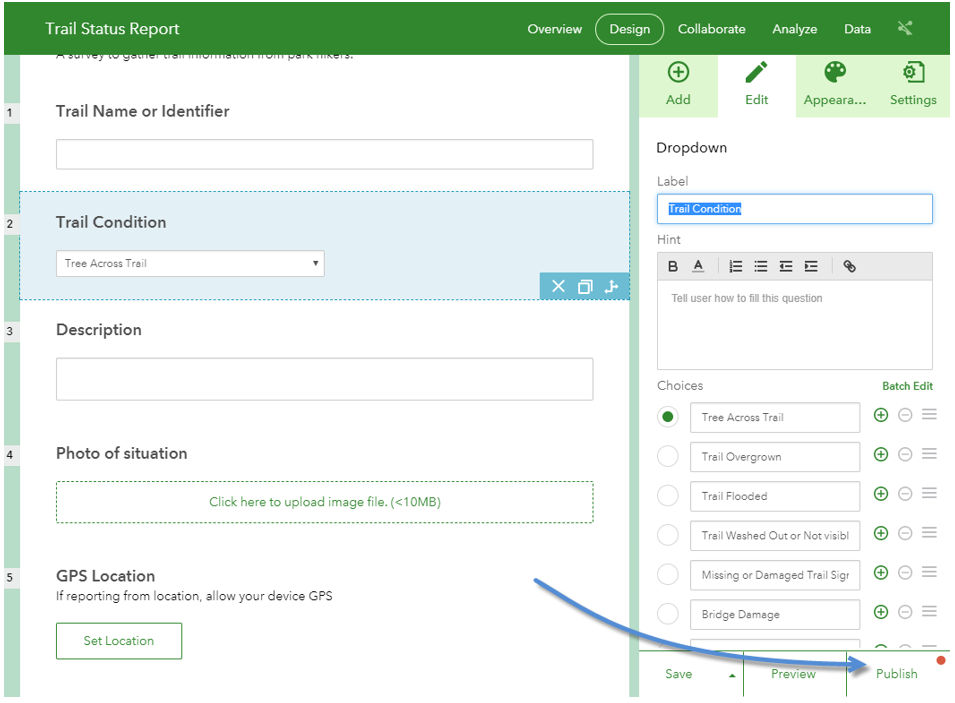
Once we have completed the questions for our survey, click the Publish button.

In our example we will be passing some attribute information from the map to our Survey.  To make this an easier setup process click Modify schema.

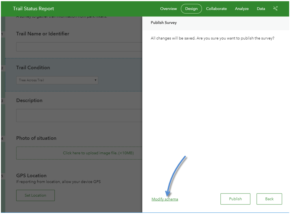
It is good practice to set the name column in the schema, rather than using the defaults.  It makes the service easier to use for other purposes.

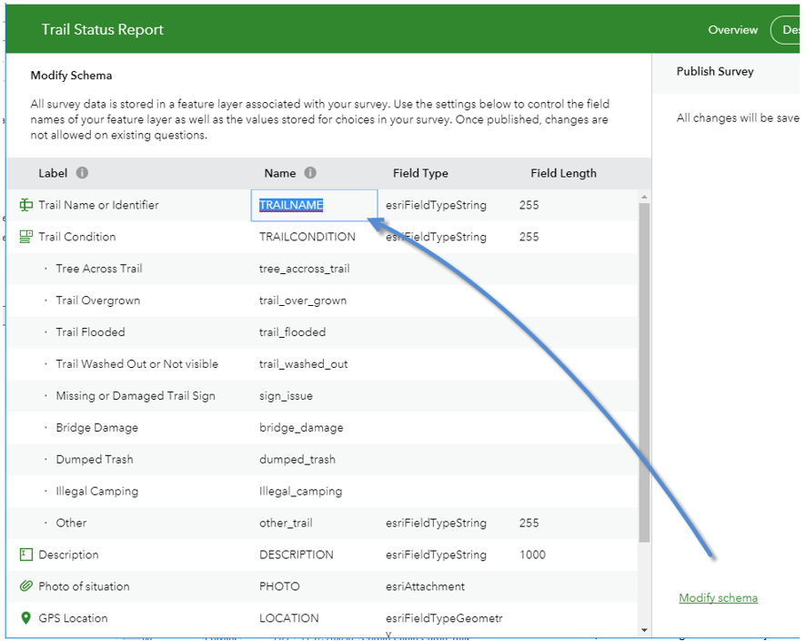
When finished renaming fields, click Publish to create the survey service.  

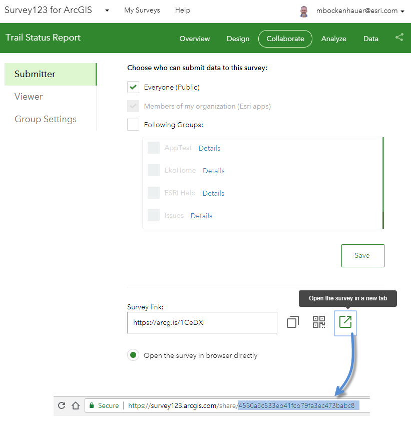
Next click Collaborate, check Everyone (Public) and click Save.  Now, anyone hiking the trail with the survey will be able to provide information.

Copy the Survey ID number from the survey link and save it for later.

Now we will work on updating an offline park map to use the survey. 

Open this Map Package in ArcGIS Pro http://www.arcgis.com/home/item.html?id=c48742ecdc784623ac15fde1e2455a72 


In this map we will update the ShenandoahNP_Trail layer pop-ups to allow user to launch the Survey we just created.

Right Click on the ShenandoahNP_Trail to Configure Pop-ups and Click the pencil to modify the Text pop-up.

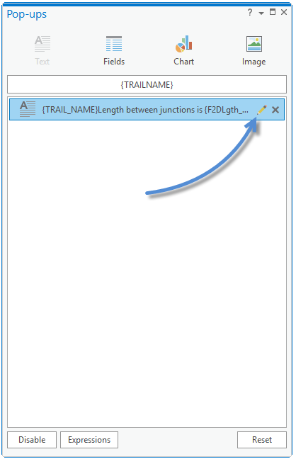
The pop-up is already defined to show the Trail Name and Length of the trail.

Add “Report Trail Status” use your mouse to highlight the text and click the hyperlink button. 

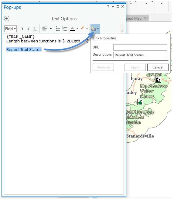
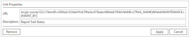
We will add an AppLink to Launch Survey123 and pass a couple trail feature attributes to the survey.

For this step you will need the field names and survey ID for the survey you created. You will use the them to create an app link URL like this one:

arcgis-survey123://?itemID=4560a3c533eb41fcb79fa3ec473babc8&field:TRAILNAME={TRAIL_NAME}&field:MAINTENANCE={MAINT_BY}

The ID and fieldname defined in the survey are in bold, the fields in our feature data are in curly brackets.

Type the App link in for the URL and click Apply.

*Pro 2.1 and later required.

Next click the back arrow on the Configure Pop-up pane.

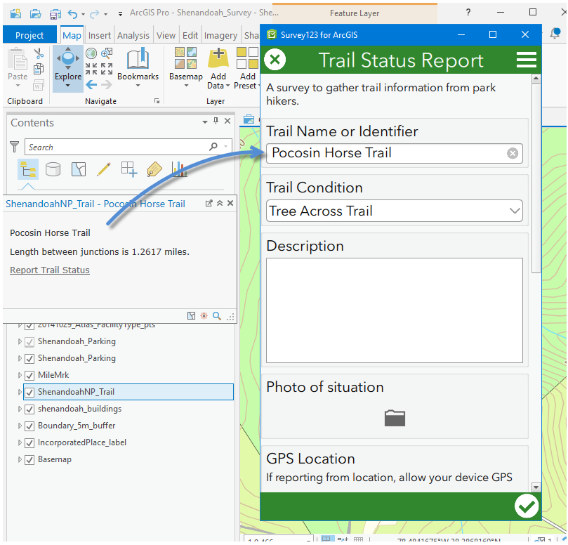
Now we will test the pop-up and App link in ArcGIS Pro.

To test the link to the survey, if you do not have Survey123 for Windows installed you can get it here https://doc.arcgis.com/en/survey123/download/

Zoom in the map and click on a trail to see the pop-up.

Click on the “Report Trail Status” link.

Survey123 opens the Trail Report Survey and the trail name and maintenance attributes are automatically filled out.

*more information about Survey123 URL scheme https://community.esri.com/groups/survey123/blog/2016/07/30/understanding-survey123s-custom-url-sche...


With a working pop-up, all we need to do is share our map with Explorer for ArcGIS users.

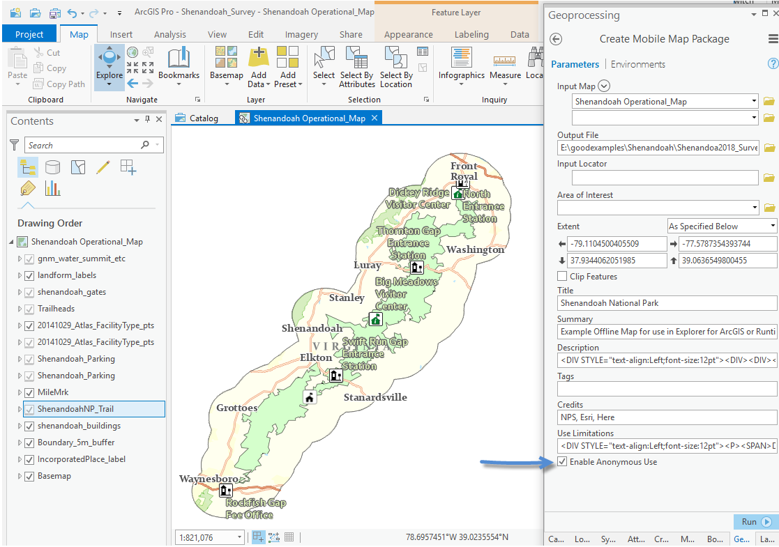
Use the Create Mobile Map Package tool to create an offline map.  The Publisher extension allows you to ‘Enable Anonymous Use’, check the box to allow the public to use the map and click run. To enable for Anonymous use your ArcGIS Pro user account will need to be provisioned with the Publisher license.

Use the Share Package tool to share your map.

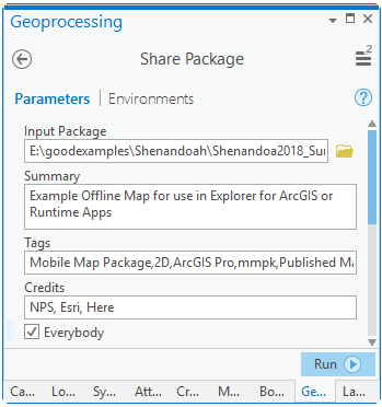
Maps that are Enabled for Anonymous use and shared with Everybody can be opened by every and any Explorer for ArcGIS user.  Explorer users can simply search for the map in the Explorer app to use it.


Our intention is to provide an offline map and offline survey that park visitors can use while hiking in the park.  The users also need the app Explorer for ArcGIS and Survey123.  They need to get all of this while connected to the internet.

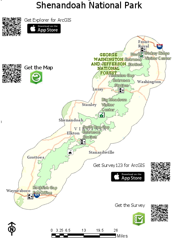
In a park scenario we might make a website for a user to download the content from, or print out a map or poster, that lets users know that this content is available, and how to make use of it.  We can even create QRcodes to make getting the content easy.

Creating QR codes and App links

Once you have shared the map, find it on ArcGIS online and view the map details to get the item ID.

Copy the item ID to your clipboard and create the following applink. (more information about Explorer app links can be found here https://github.com/Esri/explorer-integration)

arcgis-explorer://?itemID=6ca5f9cfea0c47b2969ee9750693301f


You can use this as a link on your website, and Explorer users browsing your site on their device can simply click the link to download and open the map.

<a href="arcgis-explorer://?itemID=6ca5f9cfea0c47b2969ee9750693301f">Open the map in Explorer</a>

You can also make it easy for people to get your map using a QR Code.  Just use the applink to generate a QR Code, add it to your website or print it for poster display.

Of course, users will also need Explore for ArcGIS and Survey123. You can create Links and QRcodes for those too.

For IOS

Explorer for ArcGIS Appstore link for a webpage.

<a href="https://itunes.apple.com/us/app/explorer-for-arcgis/id860708788"><img

src="data:image/png;base64,iVBORw0KGgoAAAANSUhEUgAAAIgAAAAoCAYAAAAlprK8AAAACXBIWXMAAA7

EAAAOxAGVKw4bAAAAB3RJTUUH4gEQFiAX9N0QoQAAAAd0RVh0QXV0aG9yAKmuzEgAAAAMdEVYdERlc2NyaXB0a

W9uABMJISMAAAAKdEVYdENvcHlyaWdodACsD8w6AAAADnRFWHRDcmVhdGlvbiB0aW1lADX3DwkAAAAJdEVYdFN

vZnR3YXJlAF1w/zoAAAALdEVYdERpc2NsYWltZXIAt8C0jwAAAAh0RVh0V2FybmluZwDAG

+aHAAAAB3RFWHRTb3VyY2UA9f

+D6wAAAAh0RVh0Q29tbWVudAD2zJa/AAAABnRFWHRUaXRsZQCo7tInAAAJaUlEQVR4nO1cvY7TShT

+AggoEDtUexGIOECDQFrzBDuR6DM0W9CseQK8lBSsI0RLjHiAeJ8gyRPYkZAoM9tSkMlSsU1mC4QEQucWe2eun

Ti7SZz9uZd80kiOfXLmzPjMzPlLSkQEANjb26MvX75gf38fv3//xhJ/Fi5duoS//voLd

+/exa1bt0r2ARHh48eP9PbtW7p//z5dvnyZACzbH9auXLlCDx8+pPfv39OnT5+IiEBEwGAwoNevX5+5gMt2Ptq

1a9fo3bt39PXrVyIiII5jWl1dPXPBlu38tEePHlGSJEREuNDv9/Ht2zcssYTB58+fsb

+/DwC48P379zMWZ4nzhp8/f

+LHjx8AgAun1akQAq1WC67rFuLjOE5hHtPg5cuXWF1dLcTD8zw4jrMYgXLAOQfn/MT4A6egIIwxxHGMVqsFIUQ

hXpxzSCkRhiGklIjjGIyxBUmaxZs3bwrzWLSCMMYyCvG/UJB2u20HMRgMIKUsxE9KCc45XNfF7u4uoiiyzxzHQ

a1Wy+ww6Qk09xlj9ppzDsdxsL6+fuTL5JxjfX09c8913dzvGfmOwig/I5PhmQfP89BoNMaeCyHG

+jN8ii6gE1UQz/Myg0m/zEUgDEPUajUAhxOSJAkeP36MKIrgeZ7t03VdCCHQ6/XAGIPnefZ5HMeIoghPnz5Fki

S5/UgpIYTA1tYW4jgGAMunWq1CSmlfRJIk8H0fnudNVJI8fq7rIo5j

+L6Pra2t3LlyXRc3btxAtVq190w/SZLY/nzfRxAEqFarE8c0NT58+HBi7lK73SaDKIoK8+OcU5Ik9rPjOHTorI

OiKKIgCAgACSGo1+sRAArDkHzfpyiKqN1ukxCCkiQh13UJABERcc4JACml7P3v37/T6uoqcc5JSmn71FpbGs45

bW9vU7/fJ845OY5DWmtLK6W0vNNjyOPHOSellKXp9/vHjj8IAjvmMAzttVKKGo2Glc3IO0vb2dk5dHPn0qopwR

jDYDBAvV63K3aREEKg0+nYvrTWAACtNUqlw2ixOeIcx0EYhvY676hTSuVuyYZv

+loIAd/3sbOzg8FgMCbDUZhEo5Sy17PaLmmejDF0u110u108f/48w3dWXJr7mymkz1OlFHZ2dux94HCwL168gO

M40FpDKYVOpzPVZI5iZWUFtVoNnHM8ffrU9hFFEYIgQK/XQ6PRQLvdBnC45RujNkkSRFFkn00DKSVc18WLFy8A

HL4IYwcREdbW1rC2tmZpAWB7exta69yXPMpPKWX5HQetNVzXBef8yKMjiiJsbm4iDEPcuHFjrnk2KKQgruui1W

qNTUQYhmi321BKTbS0tdYIwxD1en3q/oxiPX78GJ1OB1tbW/ZZu92G1hrVahX1ej2jBEZBACAIgszuUa/X7QqL

oshev3r1ysrpOA5834fWOqOQAFCpVDKr1HVd

+L6PwWAA3/fHVu8kfkopy1MplTsvUkr4vm8VJK0k6WtjA1Wr1UK7B4D5bRDOOS0Cvu

+fWUh52U7IBmGModVqzfPVDA4ODopb2UucKOZSEN/3FxKgMoGvJc4v5lKQRXgkOzs7S+X4D2BmBWGMoVwuF

+54Fk8iD0IIxHGMOI5PxIWeBY7joNlsot/vg4gwHA7RarVOPAx+GphZQRaVKCviegGHu5jxkIzLeBZwXRe9Xg

+e56FUKqHb7eLg4CA37+Q4TuF81KljVi9mUd7LaIRxlsYYIyIiKSVprYmIiDF2Jta

+iRaPRopHo5dm3tKR0PPc5vZiFmU3FMlymlWYJIk9qqZZmdMk5WalHY2LGMwzT4wxrK

+vT51kc103Vz4TuFxIJnmeOMgikJdrmLaZVSuEIM/ziIio3W6P0QVBYHerdF6IiCiO48yuY2g9z6MoijK0vV5v

4g4lpSQisnmQvPZP+d4YzHPGGDUajbHnzWYzV0YhhJUx3a/neTQcDjM8Go1GoR1kLgWZNOBZ0Ww2Z

+7bHC8mKWY

+E40fM2ZCh8Mhaa1tcsscS3EcT6Q1ya882nTzfd/2H8dx7tGZVjqlVCbJllZ4KSV5nkee51nFa7VaYzL2+/0MP

XCYoDT3OOc2KUg0XzCykIKkJ6UoWq0WOY4zdd9mx0if

+WaCzWSNTigRZWwC13XtfSHEkbSMMasko/wnzUccx1PbIOa

+1jqj4CZTTfSvvZaWcVQWpdREHvPs1oUiqUVd1DSEEDO5g4Y2LcNxdki3283YBFJKmwUe9cpGabXWlv

+kMz0MQ1QqFdTrdRwcHIBzjjiOp/L4jMwml2Rg8k7pMRuMFkq5rotyuYx

+v4+1tTVrx5hwRBFbZC4FSWdsi2IwGMxUSGQmtNVqgf75cU

+z2QQA1Gq1qSO8RgmmeYkm4XWUIiulEAQBHMdBt9sFYwyNRuNY3qb/vKTaJBlHQwRmzKZwKN1G

+5kVc2dzgyDA5ubmvF

+3CMNwalohBFZWVnKVyvM8lMtlCCGmUjizqqbxNswLmCYzqrWG7/vo9XpT7YxSyoklhkbGaWNGu7u78H1/Yj/z

YG4FMSnp7e3teVlgd3d3ZgUBDrfjIAgyzxzHwebmZq6CrKysjPFKp9nTyIsSm36nnWSjUKaQ6CiY/mu12tiYjI

zHJTQNj3K5DCll4SBkBkVLDo2lPCu01jMZpwCssZhXQmes

+OFwmGukGnePMUbNZnPMMEzTGu9qEm26tdtt2tzctDKZckciojAMx4xRY3QaXowxUkplZARgvZ48GfOCbcazjO

M4M6+u684VRCzkxaQbYyxXSaSUlCRJrkustZ45kmoUIF3zOUmBRj0T8wKOkiFNa/ikaQ3PdEt7GqNIkmTsxYzK

kVYe02c6jpGufz1OQSa9B6KjYzTHKUjhkkNTFeV5HoQQtqwvvXWbCnDOOZRSCMNw5konrXWm

+isPvu/bssY0lFK2hpQxBinlmIxpWt/3La

+88aRpK5WK/f2LqXVNR3jTMNVmo2UOpiLdzBFweIxGUZQZizlq8mQx5Yimyt0YrGkvbC6cZFX7WbejVlwR2j

+hnUpV

+xL/fSwVZIkjcen69etnLcOJ4agzuwjt/x2XL1/G1atXDz8kSUI3b9488zNv2c5Pe/Dgwb9/IFOpVLCxsYEllg

CAUqmEZ8+e4d69ewCAS3fu3CltbGzQxYsX0el0sLe3h1+/fp2xmEucNq5evYq7d

+9iY2MDT548we3bt0sAUKLU32Cav6Na/g3mnwfzN5iVSsUqBwD8DVjVshHYbwlqAAAAAElFTkSuQmCC"

alt="Download on the App Store" style="margin:0 10px 3px 0; vertical-align:middle"></a>

Explore Appstore QRcode

Survey123 IOS

Weblink

<a href="https://itunes.apple.com/au/app/survey123-for-arcgis/id993015031" class="download-link" style="margin:.375rem 0"><img src="data:image/png;base64,iVBORw0KGgoAAAANSUhEUgAAAIgAAAAoCAYAAAAlprK8AAAACXBIWXMAAA7

EAAAOxAGVKw4bAAAAB3RJTUUH4gEQFiAX9N0QoQAAAAd0RVh0QXV0aG9yAKmuzEgAAAAMdEVYdERlc2NyaXB0a

W9uABMJISMAAAAKdEVYdENvcHlyaWdodACsD8w6AAAADnRFWHRDcmVhdGlvbiB0aW1lADX3DwkAAAAJdEVYdFN

vZnR3YXJlAF1w/zoAAAALdEVYdERpc2NsYWltZXIAt8C0jwAAAAh0RVh0V2FybmluZwDAG

+aHAAAAB3RFWHRTb3VyY2UA9f

+D6wAAAAh0RVh0Q29tbWVudAD2zJa/AAAABnRFWHRUaXRsZQCo7tInAAAJaUlEQVR4nO1cvY7TShT

+AggoEDtUexGIOECDQFrzBDuR6DM0W9CseQK8lBSsI0RLjHiAeJ8gyRPYkZAoM9tSkMlSsU1mC4QEQucWe2eun

Ti7SZz9uZd80kiOfXLmzPjMzPlLSkQEANjb26MvX75gf38fv3//xhJ/Fi5duoS//voLd

+/exa1bt0r2ARHh48eP9PbtW7p//z5dvnyZACzbH9auXLlCDx8+pPfv39OnT5+IiEBEwGAwoNevX5+5gMt2Ptq

1a9fo3bt39PXrVyIiII5jWl1dPXPBlu38tEePHlGSJEREuNDv9/Ht2zcssYTB58+fsb

+/DwC48P379zMWZ4nzhp8/f

+LHjx8AgAun1akQAq1WC67rFuLjOE5hHtPg5cuXWF1dLcTD8zw4jrMYgXLAOQfn/MT4A6egIIwxxHGMVqsFIUQ

hXpxzSCkRhiGklIjjGIyxBUmaxZs3bwrzWLSCMMYyCvG/UJB2u20HMRgMIKUsxE9KCc45XNfF7u4uoiiyzxzHQ

a1Wy+ww6Qk09xlj9ppzDsdxsL6+fuTL5JxjfX09c8913dzvGfmOwig/I5PhmQfP89BoNMaeCyHG

+jN8ii6gE1UQz/Myg0m/zEUgDEPUajUAhxOSJAkeP36MKIrgeZ7t03VdCCHQ6/XAGIPnefZ5HMeIoghPnz5Fki

S5/UgpIYTA1tYW4jgGAMunWq1CSmlfRJIk8H0fnudNVJI8fq7rIo5j

+L6Pra2t3LlyXRc3btxAtVq190w/SZLY/nzfRxAEqFarE8c0NT58+HBi7lK73SaDKIoK8+OcU5Ik9rPjOHTorI

OiKKIgCAgACSGo1+sRAArDkHzfpyiKqN1ukxCCkiQh13UJABERcc4JACml7P3v37/T6uoqcc5JSmn71FpbGs45

bW9vU7/fJ845OY5DWmtLK6W0vNNjyOPHOSellKXp9/vHjj8IAjvmMAzttVKKGo2Glc3IO0vb2dk5dHPn0qopwR

jDYDBAvV63K3aREEKg0+nYvrTWAACtNUqlw2ixOeIcx0EYhvY676hTSuVuyYZv

+loIAd/3sbOzg8FgMCbDUZhEo5Sy17PaLmmejDF0u110u108f/48w3dWXJr7mymkz1OlFHZ2dux94HCwL168gO

M40FpDKYVOpzPVZI5iZWUFtVoNnHM8ffrU9hFFEYIgQK/XQ6PRQLvdBnC45RujNkkSRFFkn00DKSVc18WLFy8A

HL4IYwcREdbW1rC2tmZpAWB7exta69yXPMpPKWX5HQetNVzXBef8yKMjiiJsbm4iDEPcuHFjrnk2KKQgruui1W

qNTUQYhmi321BKTbS0tdYIwxD1en3q/oxiPX78GJ1OB1tbW/ZZu92G1hrVahX1ej2jBEZBACAIgszuUa/X7QqL

oshev3r1ysrpOA5834fWOqOQAFCpVDKr1HVd

+L6PwWAA3/fHVu8kfkopy1MplTsvUkr4vm8VJK0k6WtjA1Wr1UK7B4D5bRDOOS0Cvu

+fWUh52U7IBmGModVqzfPVDA4ODopb2UucKOZSEN/3FxKgMoGvJc4v5lKQRXgkOzs7S+X4D2BmBWGMoVwuF

+54Fk8iD0IIxHGMOI5PxIWeBY7joNlsot/vg4gwHA7RarVOPAx+GphZQRaVKCviegGHu5jxkIzLeBZwXRe9Xg

+e56FUKqHb7eLg4CA37+Q4TuF81KljVi9mUd7LaIRxlsYYIyIiKSVprYmIiDF2Jta

+iRaPRopHo5dm3tKR0PPc5vZiFmU3FMlymlWYJIk9qqZZmdMk5WalHY2LGMwzT4wxrK

+vT51kc103Vz4TuFxIJnmeOMgikJdrmLaZVSuEIM/ziIio3W6P0QVBYHerdF6IiCiO48yuY2g9z6MoijK0vV5v

4g4lpSQisnmQvPZP+d4YzHPGGDUajbHnzWYzV0YhhJUx3a/neTQcDjM8Go1GoR1kLgWZNOBZ0Ww2Z

+7bHC8mKWY

+E40fM2ZCh8Mhaa1tcsscS3EcT6Q1ya882nTzfd/2H8dx7tGZVjqlVCbJllZ4KSV5nkee51nFa7VaYzL2+/0MP

XCYoDT3OOc2KUg0XzCykIKkJ6UoWq0WOY4zdd9mx0if

+WaCzWSNTigRZWwC13XtfSHEkbSMMasko/wnzUccx1PbIOa

+1jqj4CZTTfSvvZaWcVQWpdREHvPs1oUiqUVd1DSEEDO5g4Y2LcNxdki3283YBFJKmwUe9cpGabXWlv

+kMz0MQ1QqFdTrdRwcHIBzjjiOp/L4jMwml2Rg8k7pMRuMFkq5rotyuYx

+v4+1tTVrx5hwRBFbZC4FSWdsi2IwGMxUSGQmtNVqgf75cU

+z2QQA1Gq1qSO8RgmmeYkm4XWUIiulEAQBHMdBt9sFYwyNRuNY3qb/vKTaJBlHQwRmzKZwKN1G

+5kVc2dzgyDA5ubmvF

+3CMNwalohBFZWVnKVyvM8lMtlCCGmUjizqqbxNswLmCYzqrWG7/vo9XpT7YxSyoklhkbGaWNGu7u78H1/Yj/z

YG4FMSnp7e3teVlgd3d3ZgUBDrfjIAgyzxzHwebmZq6CrKysjPFKp9nTyIsSm36nnWSjUKaQ6CiY/mu12tiYjI

zHJTQNj3K5DCll4SBkBkVLDo2lPCu01jMZpwCssZhXQmes

+OFwmGukGnePMUbNZnPMMEzTGu9qEm26tdtt2tzctDKZckciojAMx4xRY3QaXowxUkplZARgvZ48GfOCbcazjO

M4M6+u684VRCzkxaQbYyxXSaSUlCRJrkustZ45kmoUIF3zOUmBRj0T8wKOkiFNa/ikaQ3PdEt7GqNIkmTsxYzK

kVYe02c6jpGufz1OQSa9B6KjYzTHKUjhkkNTFeV5HoQQtqwvvXWbCnDOOZRSCMNw5konrXWm

+isPvu/bssY0lFK2hpQxBinlmIxpWt/3La

+88aRpK5WK/f2LqXVNR3jTMNVmo2UOpiLdzBFweIxGUZQZizlq8mQx5Yimyt0YrGkvbC6cZFX7WbejVlwR2j

+hnUpV

+xL/fSwVZIkjcen69etnLcOJ4agzuwjt/x2XL1/G1atXDz8kSUI3b9488zNv2c5Pe/Dgwb9/IFOpVLCxsYEllg

CAUqmEZ8+e4d69ewCAS3fu3CltbGzQxYsX0el0sLe3h1+/fp2xmEucNq5evYq7d

+9iY2MDT548we3bt0sAUKLU32Cav6Na/g3mnwfzN5iVSsUqBwD8DVjVshHYbwlqAAAAAElFTkSuQmCC" style="vertical-align:middle; height:40px;"></a>


Survey123 Appstore QRcode

For Android

Explorer for ArcGIS is in Beta, see this webpage to join the beta - https://blogs.esri.com/esri/arcgis/2017/06/15/android-beta-of-explorer-for-arcgis-is-now-available/

Survey123

Google Play web link

<a href="https://play.google.com/store/apps/details?id=com.esri.survey123" class="download-link" style="margin:.375rem 0"><img src="https://play.google.com/intl/en_us/badges/images/generic/en_badge_web_generic.png" style="vertical-align:middle; height:58px;"></a>

Google Play QRcode

A map could printed with all of the QR codes in a location that has internet access, allowing people to get everything they need on their device before going out into the field or offline.

more
8 8 11.3K
IsmaelChivite
Esri Notable Contributor

----------------------------------------------------Note start------------------------------------------------------------------------------------------

 The original content of this post is obsolete. All functionality described is now generally available as described in this video:

----------------------------------------------------Note end------------------------------------------------------------------------------------------

We are happy to announce that Survey123 will introduce support for Webhooks shortly.  If you are not familiar with webhooks, think that you will be able to integrate Survey123 workflows with Micosoft 365, Google Sheets, Box, Evernote, GMail, SMS (Simple Message System), Apple Push Notifications, Salesforce and hundreds of cloud services more!

What is a Webhook? The concept of a Webhook is simple. A WebHook is an HTTP/s callback: an HTTP/s POST that occurs when something happens; a simple event-notification via HTTP/s POST. 

The beauty of webhooks is that they are a commonly accepted pattern by many applications out there, so a whole ecosystem of different providers allows you to work with webhooks and automate processes involving things such as Microsoft 365, Evernote, Google Sheets, SalesForce...and now Survey123.

What can I do with Webhooks and Survey123? As you will find soon, many different things, but I will give you a simple scenario: Imagine you want to send an email to someone when a high priority incident is reported through a particular Survey123 form. Imagine too, that if the incident is low priority then you want the incident to be logged in a Google Sheets spreadsheet.    By configuring a webhook with Survey123, you can trigger a flow that orchestrates Gmail and Google Sheets to do what I just described. The flow could look something like this:

The flow above was built using Integromat. Integromat is a cloud application that helps you visually orchestrate different cloud services.  Integromat supports initiating these flows, or scenarios as they call them, with a webhook triggered by Survey123.

How can I do this myself? I am slow typing, so I recorded a step by step video so you can get a hang of it.  You will be able to do this by using the Early Adopter version of Survey123

Do I need to use Integromat? Not necessarily. Integromat is one of many possible solutions for using webhooks and Survey123. Other solutions include Zapier, Microsoft Flow, Tray.io, IFTT etc.  You can in fact trigger a webhook that calls your own custom developed web service, an ArcGIS geoprocessing service, an FME service etc... 

Does Esri plan to have connectors for Zapier, Microsoft Flow etc? Very likely, but we are still working out what is the specific set of connectors we will create. We want to use this Early Adopter Program to figure out which connectors you would like. For now, you can use the generic webhook connector! 

To what Survey123 event can I associate a webhook? For now, only to the submit operation in a form (Web Form or Survey123 field app). If you have use cases for other triggers, let us know.

Updated June 17, 2018: Are there any restrictions to the use of webhooks using Survey123? Yes: Webhooks will only be triggered if the end-user is logged in into the Survey123 field app or Survey123 Web Form. Survey123 webhooks will not be triggered if the form is shared publicly and the user submitting the form is not logged-in.

When is this functionality planned to be made available? We are targeting version 3.0, which will release around July 2018. Our Survey123 Early Adopter Program now lets you experiment with this feature. We are looking for your feedback through the Early Adopter Program!

more
31 60 26.5K
510 Subscribers