Turn on suggestions
Auto-suggest helps you quickly narrow down your search results by suggesting possible matches as you type.
Cancel
- Home
- :
- All Communities
- :
- Services
- :
- Esri Technical Support
- :
- Esri Technical Support Blog
- :
- Web Maps Must Be Updated if Using Styles that Adju...
Web Maps Must Be Updated if Using Styles that Adjust Symbol Size Automatically Based on Map Scale
Subscribe
2334
0
06-15-2016 03:00 PM
- Subscribe to RSS Feed
- Mark as New
- Mark as Read
- Bookmark
- Subscribe
- Printer Friendly Page
06-15-2016
03:00 PM
This blog pertains to web maps and layer items that have both of these characteristics:
Smart Mapping tools allow you to select between various methods for using attribute values to drive the size of marker symbols when mapping data associated with polygons. You can specify a concrete size range for the symbols, or use automatic sizing so that they are optimized for the initial map zoom level and will automatically adjust so they look better across more zoom levels. We discovered an issue when using the automatic sizing option where the size of each symbol was being incorrectly represented in the web map with pixel values rather than point values (points are the correct unit of measure according to the web map specification). The ArcGIS API for JavaScript was also using pixel values. The result was inconsistent sizing between ArcGIS clients.
You also have the ability to automatically adjust the width of the outline of the polygon based on the current scale. Automatic sizing of polygon outline widths were also being represented using pixels rather than points.
Starting with the June update of ArcGIS Online, sizing values will be correctly represented using points which will enable marker sizing in web maps to be displayed consistently in all ArcGIS clients. The ArcGIS API 3.17 for JavaScript was also updated to use point values rather than pixels. While this update resolves the inconsistencies with auto sizing values going forward, it also means that web maps that were created before the June 2016 update of Online will have marker symbols and polygon outline widths that appear 1.3 times larger than the initial sizes you saw when originally authoring your map.Example map with automatic sizing before the update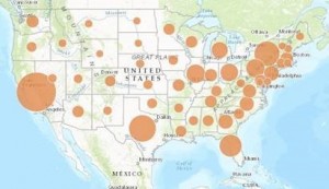 Example map with automatic sizing after the update
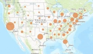 What can you do if your web map was affected by this update?
If you created a web map or layer item in Online prior to the June update with layer styles that take advantage of automatic sizing based on scale, we recommend that you reauthor your web map. This process will resave your web map with the correct sizing values for consistent display in all ArcGIS clients. Here are the steps to reauthor your web map:
For information on changing the style of your web map or layer item, see this help topic.Note: this issue also occurs in web maps and layers that were created in Portal for ArcGIS and will be addressed in Portal for ArcGIS version 10.5. This article will be updated once a solution is available.Julie Powell Technical Product Manager, ArcGIS API for JavaScript
- Web maps and layers authored with ArcGIS Online prior to the June 2016 update.
- Contains polygon layers that are styled using Smart Mapping tools to adjust symbol size and/or outline width automatically based on scale
Smart Mapping tools allow you to select between various methods for using attribute values to drive the size of marker symbols when mapping data associated with polygons. You can specify a concrete size range for the symbols, or use automatic sizing so that they are optimized for the initial map zoom level and will automatically adjust so they look better across more zoom levels. We discovered an issue when using the automatic sizing option where the size of each symbol was being incorrectly represented in the web map with pixel values rather than point values (points are the correct unit of measure according to the web map specification). The ArcGIS API for JavaScript was also using pixel values. The result was inconsistent sizing between ArcGIS clients.
You also have the ability to automatically adjust the width of the outline of the polygon based on the current scale. Automatic sizing of polygon outline widths were also being represented using pixels rather than points.
Starting with the June update of ArcGIS Online, sizing values will be correctly represented using points which will enable marker sizing in web maps to be displayed consistently in all ArcGIS clients. The ArcGIS API 3.17 for JavaScript was also updated to use point values rather than pixels. While this update resolves the inconsistencies with auto sizing values going forward, it also means that web maps that were created before the June 2016 update of Online will have marker symbols and polygon outline widths that appear 1.3 times larger than the initial sizes you saw when originally authoring your map.Example map with automatic sizing before the update
 Example map with automatic sizing after the update
 What can you do if your web map was affected by this update?
If you created a web map or layer item in Online prior to the June update with layer styles that take advantage of automatic sizing based on scale, we recommend that you reauthor your web map. This process will resave your web map with the correct sizing values for consistent display in all ArcGIS clients. Here are the steps to reauthor your web map:
- Open your web map or layer item
- Click on "Change Style" in the layer menu for the polygon layer(s) that use automatic sizing of symbols. Note: You might want to write down the options you have selected so that you can easily reselect them in step 4.
- Select a different style for your symbols than you originally had selected and click "Done."
- Click "Change Style" again on the same layer and reselect the original styling options you had, and click "Done." Any options that were configured within the original style must be reconfigured.
- Save your web map or layer item. Your web map will now have size represented using point values.
For information on changing the style of your web map or layer item, see this help topic.Note: this issue also occurs in web maps and layers that were created in Portal for ArcGIS and will be addressed in Portal for ArcGIS version 10.5. This article will be updated once a solution is available.Julie Powell Technical Product Manager, ArcGIS API for JavaScript
Labels
You must be a registered user to add a comment. If you've already registered, sign in. Otherwise, register and sign in.
About the Author
Product Engineer on the GeoAnalytics team.
Labels
-
Announcements
70 -
ArcGIS Desktop
87 -
ArcGIS Enterprise
43 -
ArcGIS Mobile
7 -
ArcGIS Online
21 -
ArcGIS Pro
14 -
ArcPad
4 -
ArcSDE
16 -
CityEngine
9 -
Geodatabase
25 -
High Priority
9 -
Location Analytics
4 -
People
3 -
Raster
17 -
SDK
29 -
Support
3 -
Support.Esri.com
60
- « Previous
- Next »