- Home
- :
- All Communities
- :
- Services
- :
- Esri Technical Support
- :
- Esri Technical Support Blog
- :
- Raster Catalogs can be used for Mosaic Datasets… R...
Raster Catalogs can be used for Mosaic Datasets… Really? How?
- Subscribe to RSS Feed
- Mark as New
- Mark as Read
- Bookmark
- Subscribe
- Printer Friendly Page

Hello Support Services blog readers. My name is Jeff, and I am a member of the Geodata Raster team at the East Coast Esri Support Services office located in Charlotte, NC. You may have read one of my previous blogs on mosaic dataset overviews or where to find data on the Web to use in your analysis. Today, I want to discuss the raster types in mosaic datasets in ArcGIS 10.
You will encounter the raster type option when adding rasters to the mosaic dataset via the Add Rasters to Mosaic Dataset tool. There are a plethora of raster type options available to be added. So many, in fact, that some may not be that obvious.
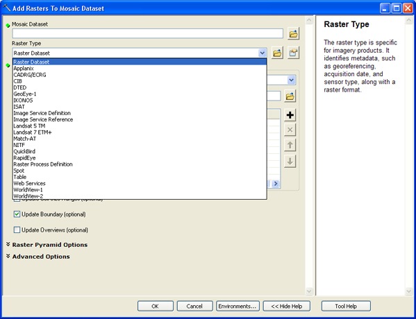
Many of the options refer to particular sensors that require specific settings to interpret and handle the format. There are a few that refer to the different data types available to be added, particularly Image Service Definition, Image Service Reference, Table, and Web Services. Hidden among the sensors is the least obvious raster type titled ‘Table’. This raster type is the setting that can be used to add raster catalogs. The Web Help documentation on this raster type says to use this type when adding the following to your mosaic dataset:
- Raster catalog
- Mosaic dataset
- Table with paths
- .dbf file (for example, from a footprint shapefile)
Each of the items in the raster catalog will become an item in the mosaic dataset. This is different than a referenced mosaic dataset, because you will be able to create overviews. Overviews cannot be created for a referenced mosaic dataset. Once the raster catalog has been added, the normal mosaic dataset process can be utilized.
This workflow should allow you to convert raster catalogs to the mosaic dataset and allow you to gain all the functionality of mosaic datasets. I hope you find these tips helpful when working with raster types in mosaic datasets. Please leave any comments you may have in the 'Comment' section below this blog post. NOTE: You must be logged in to your Esri Global Account to leave comments.
- Jeff S., Support Analyst, Geodata Raster team, ESRI Support Services
You must be a registered user to add a comment. If you've already registered, sign in. Otherwise, register and sign in.
-
Announcements
70 -
ArcGIS Desktop
87 -
ArcGIS Enterprise
43 -
ArcGIS Mobile
7 -
ArcGIS Online
21 -
ArcGIS Pro
14 -
ArcPad
4 -
ArcSDE
16 -
CityEngine
9 -
Geodatabase
25 -
High Priority
9 -
Location Analytics
4 -
People
3 -
Raster
17 -
SDK
29 -
Support
3 -
Support.Esri.com
60
- « Previous
- Next »