Turn on suggestions
Auto-suggest helps you quickly narrow down your search results by suggesting possible matches as you type.
Cancel
- Home
- :
- All Communities
- :
- Services
- :
- Esri Technical Support
- :
- Esri Technical Support Blog
- :
- If Only This Topo Map Was More Interesting
If Only This Topo Map Was More Interesting
Subscribe
2154
0
11-04-2011 12:45 PM
by
Anonymous User
Not applicable
0
0
2,154
- Subscribe to RSS Feed
- Mark as New
- Mark as Read
- Bookmark
- Subscribe
- Printer Friendly Page
11-04-2011
12:45 PM
Topographic maps are some of the most common maps that are in publication. They come in many shapes and sizes, but how can you really spice one up? What can you do to make a regular topographic map (like the one below) more interesting?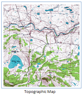
One idea, make the map 3D and it’ll become … Ta Da! ... a topographic block diagram!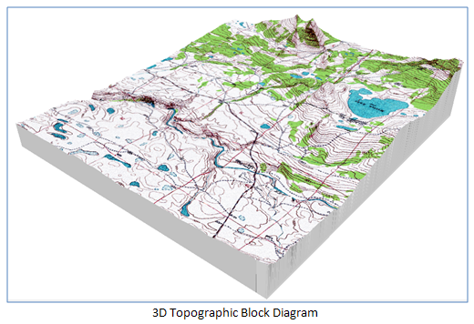
This topographic patch is a view based on three datasets (topographic raster, TIN, and multipatch) in ArcScene. The multipatch forms the bottom of the diagram and is based on the extruded result between the two TINS. The buffer polygon is used as the input feature class in the Extrude Between process. In practice, it’s good to have a 2D polygon that’s buffered just outside the edge of the elevation raster. Follow these steps to do the same to your own topographic map:
Now you will have a topographic block diagram. In the example, a topographic map was used, but the same workflow will work with a three-band raster. Keep in mind that with ArcScene, larger rasters and larger multipatches can cause issues with the display because ArcScene uses a lot of memory. Remember to check out the Optimizing ArcScene tips found on the ArcGIS Resource Center.Jeff S. - Geodata Raster Support Analyst
One idea, make the map 3D and it’ll become … Ta Da! ... a topographic block diagram!
This topographic patch is a view based on three datasets (topographic raster, TIN, and multipatch) in ArcScene. The multipatch forms the bottom of the diagram and is based on the extruded result between the two TINS. The buffer polygon is used as the input feature class in the Extrude Between process. In practice, it’s good to have a 2D polygon that’s buffered just outside the edge of the elevation raster. Follow these steps to do the same to your own topographic map:
- Create a TIN from the DEM. (You can also create a Terrain at ArcGIS 10.)
- Use the Raster Domain tool to create a polygon of the elevation area.
- Use Feature Class to Feature Class tool (disable the z value in the Environment setting).
- Buffer the polygon to extend just outside the area (buffered 1 meter in the example).
- Add Field and specify the base elevation. (This depends on the data; I selected a value of 1,200 with a bottom elevation of 1,310 for the elevation raster.)
- Create a TIN from the new polygon and specify a hard line based on the new field.
- Use the Extrude Between tool to create the multipatch.
- Open ArcScene and add the multipatch and the raster that you’re looking to enhance.
- Right-click the raster in the Table of Contents. Select properties > Base Heights and select the TIN you used.
- Select the 3D Effects Toolbar, select the multipatch and then, set the priority of the multipatch to below the raster.
Now you will have a topographic block diagram. In the example, a topographic map was used, but the same workflow will work with a three-band raster. Keep in mind that with ArcScene, larger rasters and larger multipatches can cause issues with the display because ArcScene uses a lot of memory. Remember to check out the Optimizing ArcScene tips found on the ArcGIS Resource Center.Jeff S. - Geodata Raster Support Analyst
Labels
You must be a registered user to add a comment. If you've already registered, sign in. Otherwise, register and sign in.
Labels
-
Announcements
70 -
ArcGIS Desktop
87 -
ArcGIS Enterprise
43 -
ArcGIS Mobile
7 -
ArcGIS Online
21 -
ArcGIS Pro
14 -
ArcPad
4 -
ArcSDE
16 -
CityEngine
9 -
Geodatabase
25 -
High Priority
9 -
Location Analytics
4 -
People
3 -
Raster
17 -
SDK
29 -
Support
3 -
Support.Esri.com
60
- « Previous
- Next »