Turn on suggestions
Auto-suggest helps you quickly narrow down your search results by suggesting possible matches as you type.
Cancel
- Home
- :
- All Communities
- :
- Services
- :
- Esri Technical Support
- :
- Esri Technical Support Blog
- :
- Accessing GIS attribute values in CityEngine
Accessing GIS attribute values in CityEngine
Subscribe
2633
0
05-31-2012 03:16 AM
by
Anonymous User
Not applicable
0
0
2,633
- Subscribe to RSS Feed
- Mark as New
- Mark as Read
- Bookmark
- Subscribe
- Printer Friendly Page
05-31-2012
03:16 AM
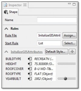
 CityEngine, through the use of CGA rules, allows for mass modeling of cities. In the current software, GIS support is available in the advanced version of CityEngine. You can access values such as land use, building heights, roof type, tree heights, etc. from a GIS feature's attribute table and then use that value to drive mass modeling rules. Below is a screen shot from the CityEngine Inspector window that shows GIS attributes for a shape that has been initialized for use through a rule file.
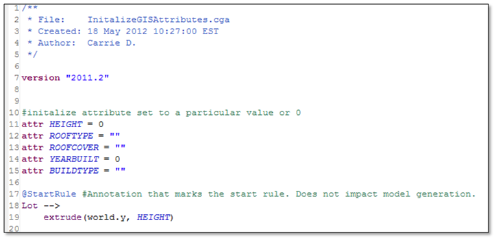
To access the GIS attribute table of a shape in your CityEngine scene, you will first need to “activate” the attribute in your rule file. This can be done by setting an initial value for that attribute at the beginning of your rule file. You can do this by initially setting all the values to zero for numeric values or to “” if it is a string field. For example, the CGA rule below will extrude shapes based on their value within the HEIGHT attribute.

For further information and great examples of using GIS data to drive your model in CityEngine, check out the resources below.
Video: Generate 3D urban content based on standard GIS data
Forum post thread: GIS Data Mini Tutorial: Building Height and Floor SplitsCarrie D. – Raster Support Analyst
Labels
You must be a registered user to add a comment. If you've already registered, sign in. Otherwise, register and sign in.
Labels
-
Announcements
70 -
ArcGIS Desktop
87 -
ArcGIS Enterprise
43 -
ArcGIS Mobile
7 -
ArcGIS Online
22 -
ArcGIS Pro
14 -
ArcPad
4 -
ArcSDE
16 -
CityEngine
9 -
Geodatabase
25 -
High Priority
9 -
Location Analytics
4 -
People
3 -
Raster
17 -
SDK
29 -
Support
3 -
Support.Esri.com
60
- « Previous
- Next »
