Turn on suggestions
Auto-suggest helps you quickly narrow down your search results by suggesting possible matches as you type.
Cancel
- Home
- :
- All Communities
- :
- Services
- :
- Esri Technical Support
- :
- Esri Technical Support Blog
- :
- 3D Analyst Toolset Recommended Workflow: Consider ...
3D Analyst Toolset Recommended Workflow: Consider the geometry of the features being used
Subscribe
2737
0
10-05-2012 05:12 AM
- Subscribe to RSS Feed
- Mark as New
- Mark as Read
- Bookmark
- Subscribe
- Printer Friendly Page
10-05-2012
05:12 AM
With the release of ArcGIS 10, new tools were made available, allowing you to use 3D objects in geoprocessing tools, and opening up new possibilities for proximity analysis. One of the new tools is the Near 3D tool, which calculates the three-dimensional distance from each input feature to the nearest feature residing in or more nearby feature classes. However, when using the new 3D analysis tools, it's always important to consider the geometry of the features being used.
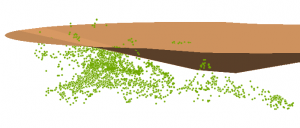
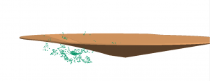
Suppose you have a 3D polygon and would like to determine whether 3D points are above versus below the surface of the polygon. Near 3D is a logical geoprocessing tool to determine which points are above and which are below, right?
To determine whether the point is above and below the polygon surface, follow this workflow instead.
1. Convert the 3d Polygon to a TIN via the Create TIN tool.
2. Use the Add Surface Information tool to add the TIN values to the point.
3. Use the Add XY Coordinate tool if you do not have z-values for your 3D point data.
4. Add a field to calculate the difference.
5. Subtract the field with the TIN Elevation from the z-value of the point.
With this workflow, if the result is positive, the point is above the surface.
So, when using the new 3D Analysis toolsets, be sure to consider the geometry of the features being used.
Suppose you have a 3D polygon and would like to determine whether 3D points are above versus below the surface of the polygon. Near 3D is a logical geoprocessing tool to determine which points are above and which are below, right?
In this particular case, the answer is no. The results from the Delta Z created in the Near 3D analysis cannot be used because the geometry of the polygon is only maintained at the edge of the polygon. Therefore, the results will be based on the distance from the point to the edge of the polygon, not the distance from the point to the polygon surface directly above or below the point.
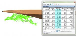
To determine whether the point is above and below the polygon surface, follow this workflow instead.
1. Convert the 3d Polygon to a TIN via the Create TIN tool.
2. Use the Add Surface Information tool to add the TIN values to the point.
3. Use the Add XY Coordinate tool if you do not have z-values for your 3D point data.
4. Add a field to calculate the difference.
5. Subtract the field with the TIN Elevation from the z-value of the point.
With this workflow, if the result is positive, the point is above the surface.
So, when using the new 3D Analysis toolsets, be sure to consider the geometry of the features being used.
References
Editing polygons in 3DJeff S. -- Raster Support Analyst
Labels
You must be a registered user to add a comment. If you've already registered, sign in. Otherwise, register and sign in.
About the Author
GIS professional with specialties in rasters, remote sensing, 3D analysis and display, spatial analytics, some python skills and market research. Been with Esri for over 14 years and worked in the industry for over 20 years.
Labels
-
Announcements
70 -
ArcGIS Desktop
87 -
ArcGIS Enterprise
43 -
ArcGIS Mobile
7 -
ArcGIS Online
22 -
ArcGIS Pro
14 -
ArcPad
4 -
ArcSDE
16 -
CityEngine
9 -
Geodatabase
25 -
High Priority
9 -
Location Analytics
4 -
People
3 -
Raster
17 -
SDK
29 -
Support
3 -
Support.Esri.com
60
- « Previous
- Next »


