- Home
- :
- All Communities
- :
- Services
- :
- Esri Technical Support
- :
- Esri Technical Support Blog
- :
- When to use the Define Projection tool and the Pro...
When to use the Define Projection tool and the Project tool?
- Subscribe to RSS Feed
- Mark as New
- Mark as Read
- Bookmark
- Subscribe
- Printer Friendly Page
"When do I use the Define Projection tool and the Project tool?," we hear you ask. Well, this blog post should be able to answer your question!
The Define Projection tool
Spatial data implicitly has coordinate values in either geographic or projected coordinates. A geographic coordinate system (GCS) uses a three-dimensional spherical surface to define locations on the earth; whereas, a projected coordinate system is defined on a flat, two-dimensional surface. Unlike a geographic coordinate system, a projected coordinate system has constant lengths, angles, and areas across the two dimensions. However, we need to explicitly define the coordinate system of our data. If we have undefined data, then we can use the Define Projection tool to define it. Otherwise, when data without a defined spatial reference is added to ArcMap, a dialog box will display that lists the data sources that are missing spatial reference information.

Figure 1: Dataset missing Spatial Reference
If the data that you added to ArcMap has coordinate values that are projected, 'Unknown Units' will be displayed next to your coordinates in the data view until the projected coordinate system is defined.

Figure 2: The units are listed as Unknown
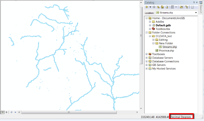
If the dataset that you added to ArcMap has geographic coordinates, the units will still display as ‘Decimal Degrees’ or in Degrees, Minutes and Seconds (DMS) (e.g. 82°45'46.8"E 41°44'56.4"N) even though the datum has yet to be defined. This is because latitude and longitude values always have angular units.

Figure 3: The Decimal Degrees units are displayed even though it's undefined
Defining a geographic or projected coordinate system for a shapefile, Esri Grid format, raster dataset (TIFF, JPG) or a file geodatabase does not require you to output to a new dataset. The Define Projection tool updates your existing dataset by creating an associated file (e.g. .prj, prj.adf,.aux). For personal geodatabases, the spatial reference table is updated.
For shapefiles, Esri Grids, raster datasets, and file/personal geodatabase feature classes you will need to go to ArcToolbox > Data Management Tools > Projections and Transformations > Define Projection to assign a geographic or projected coordinate system to your dataset.
A principle of good data management is to obtain the projected or geographic coordinate system parameters from your data source provider or associated metadata. It is strongly advised that you do not make an educated guess about the coordinate system of your data, as an inaccurate GIS database usually results. However, if you do not have access to the data source provider you can try using the steps in Esri Knowledge Base Article 24893 to identify an unknown projected coordinate system using ArcMap.
The Project tool
To change from one coordinate system to another, use the Project tool from ArcToolbox. When using the Project tool a new output dataset is created.
For shapefiles and feature classes, you will need to go to ArcToolbox > Data Management Tools > Projections and Transformations > Feature > Project to transform your dataset to another coordinate system.

Figure 4: The Project tool
To project multiple shapefiles or feature classes:
- Right-click the Project tool and select the Batch mode.
- Select the shapefile or feature class to be projected.
- Specify a location and name for the new projected data.
- If you're using the Batch mode of the Project tool, double-click the output dataset cell to browse to a location and save.
After specifying the location and name for the new projected data, specify the output coordinate system to project the data. If it is required, select an optional geographic transformation and complete the projection!
Additional Resources
For more information, refer to these articles:
HowTo: Project shapefiles or geodatabase feature classes with the ArcToolbox Project wizard or Tool
FAQ: Projection Basics: What the GIS professional needs to know
How To: Select the correct geographic (datum) transformation when projecting between datums
Rajeshwary K. - Online Support Resources
You must be a registered user to add a comment. If you've already registered, sign in. Otherwise, register and sign in.
-
Announcements
70 -
ArcGIS Desktop
87 -
ArcGIS Enterprise
43 -
ArcGIS Mobile
7 -
ArcGIS Online
22 -
ArcGIS Pro
14 -
ArcPad
4 -
ArcSDE
16 -
CityEngine
9 -
Geodatabase
25 -
High Priority
9 -
Location Analytics
4 -
People
3 -
Raster
17 -
SDK
29 -
Support
3 -
Support.Esri.com
60
- « Previous
- Next »