Turn on suggestions
Auto-suggest helps you quickly narrow down your search results by suggesting possible matches as you type.
Cancel
- Home
- :
- All Communities
- :
- Services
- :
- Esri Technical Support
- :
- Esri Technical Support Blog
- :
- Creating KML files with Attribute Data
Creating KML files with Attribute Data
Subscribe
13363
2
02-19-2011 11:14 AM
- Subscribe to RSS Feed
- Mark as New
- Mark as Read
- Bookmark
- Subscribe
- Printer Friendly Page
02-19-2011
11:14 AM
A Keyhole Markup Language (KML) file is a great way to view GIS data outside of ArcMap. Although there are many different ways to package and make data available, KML provides a simple format that can be viewed in a myriad of applications and can also be easily distributed to others.
Map layers can be converted to KML through the tools within the To KML toolset (ArcToolbox > Conversion Tools > To KML).
Although the tools within this toolset produce a KML quickly, the output lacks attribute data if not set up correctly. As in the example below, the KML only has the feature name. The name comes from the label expression of the ArcMap layer.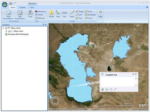
As you can see in the following screen shot, the Major Lakes Feature Class has some valuable attribute data that could be helpful if added to a KML file.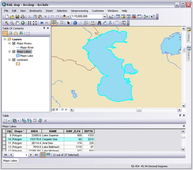 Steps to Add Attribute Data to KML Files
1. Open Layer Properties of the layer to be converted to KML.
2. Click on the HTML Popup Tab
3. Check “Show content for this layer using the HTML Popup tool 4. Select the desired HTML formatting.
a. The table of visible fields is the default option and best for HTML content embedded inside geodatabase fields.
b. The URL is best for pointing features at a set of predefined HTML pages.
c. The formatted page based on an XSL template is best for advanced formatting.
5. Verify the HTML format.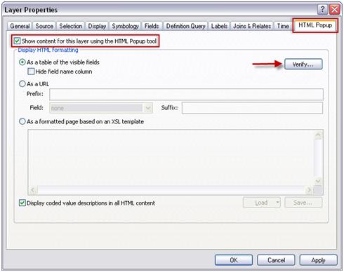
A HTML Verification window will display an example of the popup.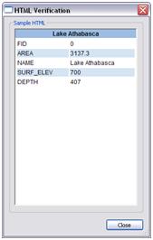
Once you have the desired results, proceed to use either the Layer to KML tool or the Map to KML tool to create the KML file.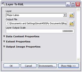
After you add the KML file to your application, you can see the added attributes for the features by clicking on it.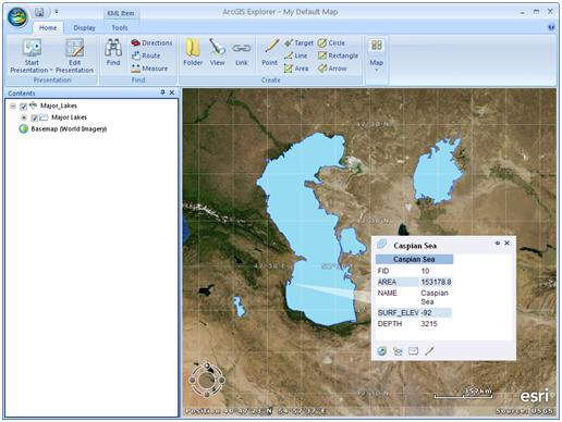
For additional information on KML, please see the following resources:Learn More about KMLPreparing your map documents in ArcGIS for KML publishingLayer to KML (Conversion)About KML support in ArcGISSetting HTML pop-up properties for feature layers
-Timothy H., Support Analyst – Geodata Raster Group, Esri Support Services - Charlotte, NC
Map layers can be converted to KML through the tools within the To KML toolset (ArcToolbox > Conversion Tools > To KML).
Although the tools within this toolset produce a KML quickly, the output lacks attribute data if not set up correctly. As in the example below, the KML only has the feature name. The name comes from the label expression of the ArcMap layer.
As you can see in the following screen shot, the Major Lakes Feature Class has some valuable attribute data that could be helpful if added to a KML file.
Steps to Add Attribute Data to KML Files1. Open Layer Properties of the layer to be converted to KML.
2. Click on the HTML Popup Tab
3. Check “Show content for this layer using the HTML Popup tool 4. Select the desired HTML formatting.
a. The table of visible fields is the default option and best for HTML content embedded inside geodatabase fields.
b. The URL is best for pointing features at a set of predefined HTML pages.
c. The formatted page based on an XSL template is best for advanced formatting.
5. Verify the HTML format.
A HTML Verification window will display an example of the popup.
Once you have the desired results, proceed to use either the Layer to KML tool or the Map to KML tool to create the KML file.
After you add the KML file to your application, you can see the added attributes for the features by clicking on it.
For additional information on KML, please see the following resources:Learn More about KMLPreparing your map documents in ArcGIS for KML publishingLayer to KML (Conversion)About KML support in ArcGISSetting HTML pop-up properties for feature layers
-Timothy H., Support Analyst – Geodata Raster Group, Esri Support Services - Charlotte, NC
Labels
2 Comments
You must be a registered user to add a comment. If you've already registered, sign in. Otherwise, register and sign in.
About the Author
Timothy Hales is a Senior Education Specialist for Esri Training Services developing instructor-led and web courses. Before developing training content for Training Services, he was the Enterprise Community Manager for Esri Community (GeoNet).
Labels
-
Announcements
70 -
ArcGIS Desktop
87 -
ArcGIS Enterprise
43 -
ArcGIS Mobile
7 -
ArcGIS Online
22 -
ArcGIS Pro
14 -
ArcPad
4 -
ArcSDE
16 -
CityEngine
9 -
Geodatabase
25 -
High Priority
9 -
Location Analytics
4 -
People
3 -
Raster
17 -
SDK
29 -
Support
3 -
Support.Esri.com
60
- « Previous
- Next »