- Home
- :
- All Communities
- :
- Services
- :
- Esri Technical Support
- :
- Esri Technical Support Blog
- :
- Lacking intensity? Don’t worry, I know how to find...
Lacking intensity? Don’t worry, I know how to find it.
- Subscribe to RSS Feed
- Mark as New
- Mark as Read
- Bookmark
- Subscribe
- Printer Friendly Page
There are many tools and workflows in ArcGIS 10 that can be used to process lidar data in order to create digital elevation models in a terrain or even, a raster. Between training , help and blog posts, there are tons of resources out there with information on the steps to create DEM rasters out of lidar points.
One of the more interesting parts of the process is creating the intensity raster from the Lidar points. This blog post from the Geoprocessing Team states this can yield "a measure, collected for every point, of the return strength of the laser pulse that generated the point." Reviewing the intensity is a good way to evaluate the quality of the lidar data being used.
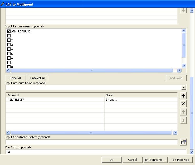
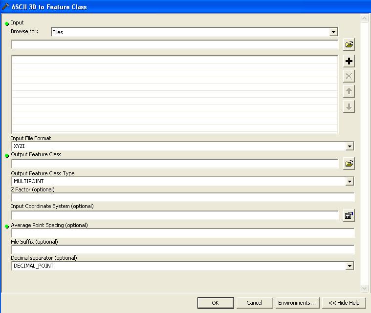
In order to create the intensity raster, you'll need the proper data form (either LAS or XYZI) and you'll have to specify the option to "include the intensity field" when using the LAS to Multipoint tool or Ascii to 3d Feature Class.
For the Ascii to 3d Feature Class, be sure that you have changed the selection of "Input File Format" to XYZI.
Once you have the multipoint file set with the intensity, you'll be ready to create your raster. The blog post recommends using the Point to Raster tool and then selecting the Intensity field. It sounds simple enough, but you may run into a problem if you are working in ArcMap. With the default at 10.0, you will not be able to see or select the intensity field in the tool or attribute table of the multipoint file in ArcMap. That's because ArcMap does not display these BLOB fields automatically. In order to see the BLOB field, go into the layer properties and fields tab to turn on the Intensity field.

In ArcCatalog, the Intensity field can be seen in the table preview or when the Tool is run by default.
So, now the Point to Raster tool can see the field and the raster can be created as desired.

For more on this process, please see the related link below. The rest of the steps are also available online in the webhelp.
Related links:
Lidar Solutions in ArcGIS_part5: Creating Intensity Images from Lidar
http://blogs.esri.com/Dev/blogs/geoprocessing/archive/2009/05/12/Lidar-Solutions-in-ArcGIS_5F00_part...
You must be a registered user to add a comment. If you've already registered, sign in. Otherwise, register and sign in.
-
Announcements
70 -
ArcGIS Desktop
87 -
ArcGIS Enterprise
43 -
ArcGIS Mobile
7 -
ArcGIS Online
21 -
ArcGIS Pro
14 -
ArcPad
4 -
ArcSDE
16 -
CityEngine
9 -
Geodatabase
25 -
High Priority
9 -
Location Analytics
4 -
People
3 -
Raster
17 -
SDK
29 -
Support
3 -
Support.Esri.com
60
- « Previous
- Next »