ArcGIS QuickCapture Blog

cancel
Showing results for 
Show  only  | Search instead for 
Did you mean: 

Other Boards in This Place


Latest Activity

(64 Posts)
JohnathanHasthorpe
Esri Regular Contributor

QuickCapture projects in Survey123 Mobile

Earlier this year, we announced that the current generation ArcGIS QuickCapture mobile app is being deprecated and will be retired at a future date. Importantly, this is not a deprecation of QuickCapture as a product. QuickCapture projects continue to be authored in the QuickCapture designer, and the big-button data capture experience remains an important part of ArcGIS field operations.

The next step for QuickCapture mobile workflows is Survey123 Mobile, the next generation field data collection app built using modern technology. Survey123 Mobile is designed to open both Survey123 surveys and QuickCapture projects, bringing smart forms and rapid data capture together in one app.


Why Survey123 Mobile?

Many organizations already use Survey123 and QuickCapture side-by-side. Survey123 is used when the workflow needs a smart form, validation, calculations, repeats, conditional logic, or a more guided data entry experience. QuickCapture is used when the workflow needs fast, simple, big-button capture with minimal interaction.

Survey123 Mobile brings these two experiences closer together. Instead of asking mobile workers to install, sign in to, and move between separate apps, the goal is to support both types of work from a single mobile application.

  • One app to install and manage.
  • One sign-in experience for mobile workers.
  • One place to access smart forms and rapid capture projects.
  • Tighter integration between Survey123 surveys and QuickCapture projects.
  • A modern foundation for incremental improvements over time.


Combining rapid capture and smart forms

One of the most useful patterns is to start with a QuickCapture project and then open a Survey123 survey when more detail is required. A mobile worker can capture common observations quickly using big buttons, then launch a survey for the cases that need structured follow-up information.

This can be configured using link buttons in QuickCapture. A link button can open a Survey123 survey using the Survey123 app link or custom URL scheme. You can also use URL parameters to configure the experience so that, after the survey is submitted, the user returns to the QuickCapture project.

Example workflows:

  • Roadside observations and detailed inspections. A crew uses big buttons to rapidly capture common roadside issues such as potholes, damaged signs, or debris. If a button represents an issue that requires a full inspection, it opens a Survey123 form where the worker can add photos, assess severity, record measurements, and submit a more detailed report.
  • Environmental monitoring and incident reporting. A field team records routine observations with QuickCapture buttons while moving through a site. When they encounter an exception, such as erosion, contamination, or an access issue, a linked Survey123 survey guides them through the additional information needed for investigation and follow-up.
  • Event operations and public works. Staff use rapid capture to record common operational observations during an event or maintenance run. For specific cases, such as a safety concern or asset damage, they open a Survey123 form to capture a structured assessment, assign a priority, and provide supporting details.
  • Damage assessment and triage. Teams can quickly classify observed damage using big buttons, then open a Survey123 survey when a more complete assessment is required. This allows rapid situational awareness and detailed reporting to work together without changing apps.


What works today, and what comes next

The first releases of Survey123 Mobile are not intended to provide full parity with the current QuickCapture mobile app. Some QuickCapture capabilities are available today, some are in development, and others are planned for future releases.

That is why customer testing and feedback are so important at this stage. We are adding functionality incrementally, and your feedback will help us understand which QuickCapture capabilities matter most for your workflows as you plan your migration.

To check the current status of QuickCapture capabilities in Survey123 Mobile, review the QuickCapture capability documentation. This documentation identifies which functionality is available, in development, planned, or not planned.


How to test your projects in Survey123 Mobile

The latest Survey123 Mobile beta builds are available through the Survey123 Early Adopter Community and will typically include features and fixes before they are released through the app stores. If you’re new to EAC, you will need to create an account first. You can also download Survey123 Mobile from the app stores and the Survey123 resources page to test your existing workflows using the most recent public release.

When testing, start with the QuickCapture projects that are most important to your organization. Open each project in Survey123 Mobile, try the most common workflows, and note any gaps that would prevent your team from migrating. Share your feedback through the EAC feedback channel:

  • Which project types work well today?
  • Which capabilities are required before you can move your users to Survey123 Mobile?
  • Which improvements would make the combined Survey123 and QuickCapture experience better for your teams?

Note: You do not need to reauthor your existing projects to test them in the beta app. Your projects will appear on the app’s downloads page.


We need your feedback

Your testing will help us prioritize the QuickCapture capabilities that matter most. Please use the Early Adopter Community to share feedback, report issues, and tell us which QuickCapture capabilities you need to successfully move your workflows to Survey123 Mobile.

This is a transition, and we want to make it a successful one. Survey123 Mobile gives us a modern foundation for the next generation of field data collection, while preserving the value of rapid, big-button capture. With your feedback, we can continue to improve the experience and help organizations bring their QuickCapture and Survey123 workflows together in one place.

more
3 0 148
JohnathanHasthorpe
Esri Regular Contributor

Learn about the upcoming retirement of Oriented Imagery Classic and how to migrate your projects to the new Oriented Imagery Layer with just one click. Future-proof your workflows today!
Read more...

more
2 3 961
ChrisLeSueur
Esri Contributor

he June 2025 release (v1.23.7) introduces several key updates that address user feedback, enhance performance, and expand customization options. Including

Read more...

more
2 0 956
DianaAschmoneit
Esri Contributor

2025 FM LS Survey.png


Location sharing has been a popular capability of ArcGIS and continues to be highly sought within our user community. Organizations that have enabled location sharing can benefit from operational awareness of their personnel and assets in near real-time, monitoring field work as it progresses and enabling faster responses to changing conditions if needed.

To achieve greater understanding of customer needs, we would like to get feedback from those who currently use location sharing, either for identifying the current or last known locations of personnel or for viewing the history of where personnel have been. As well, understanding the ArcGIS apps you are using for location sharing and the duration of time and number of staff participating are relevant to our exploration of how best to deliver improved access and user experience.

We would appreciate you taking our 12-question survey that is expected to take 3 minutes or less to complete. There is also a field for you to share general feedback about Esri’s location sharing capability. If there are others in your organization who may also have insights to contribute, please share the survey link with them.

The valuable feedback that our customers are uniquely able to provide will help to ensure that we take steps that bring greater location sharing capability in ArcGIS that more fully meets and satisfies customer needs. Thank you for participating in the survey.

more
1 0 402
JohnathanHasthorpe
Esri Regular Contributor

Sharing QuickCapture Projects Publically

There may be situations where you want to share a QuickCapture project publicly, meaning users won’t need to enter a username and password to download the project and submit data. This is useful for applications such as crowdsourcing, where you want members of the public to submit data. In these cases, you won’t know who your users are and won’t be able to assign individual licenses to them.

Sharing QuickCapture projects publicly can be done using the QuickCapture Web Designer, but the implementation differs depending on whether you are using ArcGIS Online (AGOL) or ArcGIS Enterprise.

ArcGIS Online (AGOL)

If you are using AGOL, you can share QuickCapture projects publicly, as long as your organization has a Hub Premium license. Once this is applied, the designer will allow you to share the project with Everyone (Public).

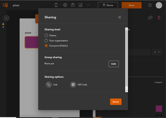
How to Share: Click the 'Share' button, then select the option to Share with everyone. This will make the project public, along with any associated project layers and web maps, if necessary.

JohnathanHasthorpe_0-1738106031972.png

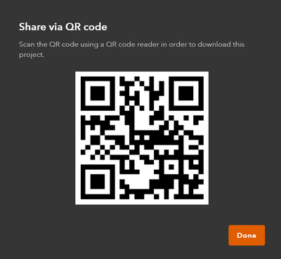
Once shared, you can distribute the QR code (created by the designer) to users via email or embed it in a document.

JohnathanHasthorpe_0-1738117604043.png

Users can scan the QR code using their mobile phone camera. If QuickCapture is not already installed, they will be directed to the appropriate app store to download it. After installation, scanning the QR code will automatically download the project to the app’s public workspace, ready for use.

Note: The designer also allows you to create project links as an alternative to QR codes. These links can be embedded in emails or documents as another way to distribute your public projects.


ArcGIS Enterprise

If you are using ArcGIS Enterprise, no additional license is required to share QuickCapture projects publicly. The option to share your project is always available, and the QuickCapture Designer will allow you to create project QR codes and links, just like you can do in ArcGIS Online.

However, there are some important considerations:

  1. External Access: If you want your project to be accessible outside of your internal network, ensure that your portal is accessible externally. In some cases, a VPN can be used if only certain members of your organization need access. In other cases, you may need to adjust your firewall settings to allow external access to the portal, the project, and associated items.

  2. Web Maps: A bug in QuickCapture prevented web maps from loading in public projects (BUG-000166936). The fix is available in version 1.21 of the Web Designer and will be available in the Enterprise-hosted version of the designer in ArcGIS Enterprise version 11.5. Additionally, it will require the map to be updated in existing projects and the project resaved. If you are using an older version of ArcGIS Enterprise, you will need to use the online version of the Web Designer with your Enterprise. See the following steps to fix your existing projects.

Use the online Web Designer with your Enterprise:

  1. Go to the online version of the designer: ArcGIS QuickCapture Designer.
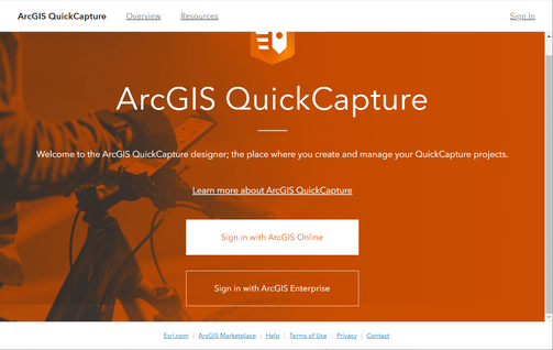
  2. Select Sign in with ArcGIS Enterprise.JohnathanHasthorpe_1-1738117676127.png
  3. Enter your portal URL and sign in with your ArcGIS Enterprise credentials.
  4. Open the project you want to share publically and go to Configure Project Map.
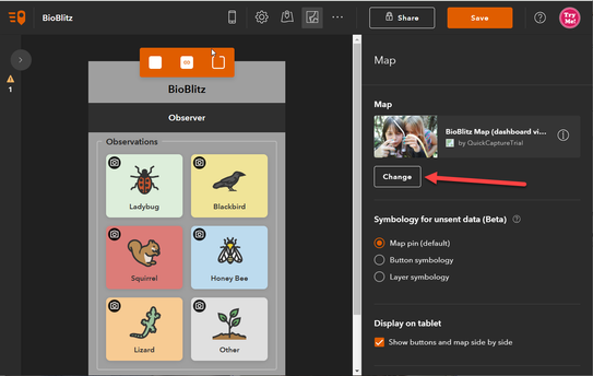
  5. Select Change and choose the map you want to use. Even if the correct map is already selected, reselect it to ensure the correct property is set.JohnathanHasthorpe_2-1738117746660.png
  6. Save the project and share it publicly, if needed.

more
2 0 1,563
JohnathanHasthorpe
Esri Regular Contributor

The supportsApplyEditsWithGlobalIDs warning

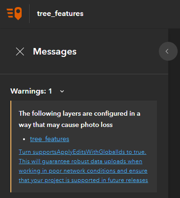
The QuickCapture designer shows a warning if your project contains feature layers that have the supportsApplyEditsWithGlobalIDs property is set to false. Many feature layers (including those created from the ArcGIS Online templates) by default will have this property set to false, so if you create a QuickCapture project from them, you will see the following warning in the QuickCapture Designer analyser UI:

JohnathanHasthorpe_1-1737075413789.png

(The following layers are configured in a way that may cause photo loss)

Currently, this is just a warning, meaning that you can still save the project without applying the fix. However it is strongly recommended that you don’t ignore it. In the future we will make this an error, which will prevent you from saving the project, until the issue is resolved. See this deprecation notice.

The reason that supportsApplyEditsWithGlobalIDs is important is that the setting that supports reliable transactions when uploading attachments (particularly when working in low bandwidth conditions) and helps the QuickCapture mobile app to prevent the upload of duplicate features.

I'm seeing the warning in the QuickCapture Designer, what do I do?

If you are using a hosted feature service in ArcGIS Online, setting supportsApplyEditsWithGlobalIDs is really simple. You just need to enable the Sync capability on your layer. It does not matter if there are existing features and attachments in the layer, the steps will still work. You can follow the steps outlined in this blog.

If you are using non hosted feature layers or ArcGIS enterprise then the steps shared in this Survey123 blog, also apply to QuickCapture.


more
1 0 1,693
JohnathanHasthorpe
Esri Regular Contributor

Encountering duplicate feature submissions in QuickCapture could be experienced when working in areas areas with poor network connectivity. This article explains the underlying cause of duplicate submissions and shares information on how the issue is addressed in the 1.21 release.

Read more...

more
2 6 2,702
JohnathanHasthorpe
Esri Regular Contributor

QuickCapture offers two types of templates to help you get started quickly with your data collection projects: Solution-based templates and Project-based templates. In this blog, we’ll explore both types and how they can help streamline your project creation process.

Read more...

more
2 0 1,363
JohnathanHasthorpe
Esri Regular Contributor

QuickCapture 1.20 release update for Mobile (Android, iOS and Windows) and web designer.

Read more...

more
1 0 1,942
JohnathanHasthorpe
Esri Regular Contributor

The QuickCapture designer now offers 2 options for enabling oriented imagery in the designer: Oriented imagery and Oriented imagery (Classic). The first option utilizes the new oriented imagery feature layer item type, that is well integrated into the ArcGIS platform. For example, the layer can be directly opened in the ArcGIS Online Map Viewer or in ArcGIS Pro. The the second option (classic) untilzes the old catalog item type, which can be consumed by stand alone web apps and an community supported ArcGIS Pro addin. 

For any layers in your project, you can enable both options! This is because for the time being the oriented imager feature layer implementation, does not yet match the capabilities of the classic verion (yet).

Read more...

more
4 0 1,384
142 Subscribers