ArcGIS Hub Blog

cancel
Showing results for 
Show  only  | Search instead for 
Did you mean: 

Other Boards in This Place


Latest Activity

(94 Posts)
EthanMink
Esri Contributor

The 2025 Esri User Conference is right around the corner, and we are excited to connect with you. UC is filled with many presentations and events, with hundreds of topics covered. To help you get the most out of your experience, we’ve created a custom agenda for ArcGIS Hub. We hope these sessions will be enjoyable and informative as you continue your geospatial journey.

View our Hub custom agenda that you can add directly to your UC account.

We also have SIGs (Special Interest Groups) available for you to attend this year. Two great SIGs that you might find particularly interesting are the:

Geospatial Ecosystems SIG: Improving ROI for Modern SDI

Community Engagement SIG: Using Hubs for Deeper Collaboration

SIGs are a great way to hear from and network with like-minded professionals. This year advanced sign-ups for SIGs will be required, ensuring everyone who signs up will have a seat, and that there is ample room. It’s easy to reserve, just register for UC and add sessions to your schedule. You can also join a waitlist if your SIG is full, as seats will open as others update their plans. Reservations will be held until 5 minutes before the start time.  If you forget to sign up, or find yourself available at the last minute, any extra spots will be made available at the door on a first-come, first served basis.

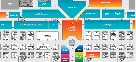
The ArcGIS Hub kiosk will be in the ArcGIS Geospatial Platform area. If you would like a like a pdf of the Hub schedule to print and take with you, it is attached below.

EthanMink_0-1748535885495.png

We hope you have a wonderful UC experience this year!

more
1 0 192
HarshithaDondapati1
Esri Contributor

ArcGIS Hub is set to receive two significant updates in the upcoming weeks: workspaces and enhanced events.

Read more...

more
1 1 885
IkechukwuChristian-Ezeofor
Esri Contributor

A practical workaround for achieving better contrast and accessibility 

IkechukwuChristianEzeofor_0-1747780505025.png


Read more...

more
3 0 123
Rhonda_Houser
Esri Contributor

Exploring and downloading data is a key function of ArcGIS Hub sites. Many people do this through the standard user interface by discovering a site, searching for data, or finding a dataset on the ArcGIS Hub homepage. In Hub, you can explore spatial data by filtering, styling, and downloading datasets in a variety of formats. Learn more about recommendations, settings, and file formats available for data downloads.

Downloads API v1 versus Legacy Downloads API

Many Hub site visitors and customers also use the Downloads API to dig into data. Hub supports the Downloads API v1, which is the newer version. The Downloads API v1 allows you to programmatically filter and download public data from service-backed items in a public catalog. You can download a single layer or download multiple layers from the same service-backed item.

Read more...

more
4 0 378
JustinPrather
Esri Contributor

If you have enabled workspaces (beta) of ArcGIS Hub, then you have a new experience for managing your site’s pages.

Read more...

more
0 10 578
Rhonda_Houser
Esri Contributor

As an organization administrator or site editor, you can specify the basemap used across your ArcGIS Hub sites. Basemaps are a big part of how we create, share, and understand geographic information. A basemap is a background map for other data layers, all anchored by location to the surface of the earth. Consult the newly republished Esri GIS dictionary for a full definition.


Mid-century mapMid-century map

As a basis for geographic analysis and visualization, basemaps provide spatial context, place names, a lot of style, and so much more. ArcGIS Online, ArcGIS Pro, and other applications offer basemaps featuring satellite imagery, streets, topography, and oceans, just to name a few.

Read more...

more
2 0 400
HarshithaDondapati1
Esri Contributor

With the ArcGIS Online February 2025 update, all existing Creator user type community accounts in Hub community organizations have been automatically updated to the Hub Community Member user type.

Read more...

more
3 0 223
ChelseaNivison
Esri Contributor

In June 2024, user types were updated across Esri technology to streamline licensing and better align with customers’ needs. Accordingly, to more closely match user types with the needs of Hub community members, an updated Hub Community Member user type will go into effect with the ArcGIS Online update in February 2025. This update will happen automatically, and user types will continue to facilitate workflows and productivity. 

Read more...

more
4 6 3,150
AndrewTurner
Esri Contributor

The ArcGIS Hub AI Assistant is a new capability  that transforms how people interact with open data. This innovative tool harnesses the power of generative AI to make open data more accessible, understandable, and actionable for everyone. It's intended to help users find answers to their questions and limited to the curated open data sets available on your Hub sites.

Read more...

more
10 2 5,278
RohitSharma-1
Esri Alum

Metrics matter for project tracking 
Metrics play a key role in tracking project efficacy by offering transparent, data-driven insights. ArcGIS Hub Premium customers can configure metrics to track and share progress toward meeting project goals.  

Whether you are managing spatial analysis projects, monitoring workflows, or communicating progress to stakeholders, having clear, structured metrics helps ensure everyone is on the same page. Metrics allow teams to track progress against objectives, make data-informed decisions, and support improved project outcomes. 

Read more...

more
3 0 544
182 Subscribers