Implementing ArcGIS Blog - Page 9

cancel
Showing results for 
Show  only  | Search instead for 
Did you mean: 

Latest Activity

(183 Posts)
RaymondBunn
Esri Contributor

Numerous technical sessions, spotlight talks, and conversations referenced the "Architecting the ArcGIS Platform: Best Practices" whitepaper (https://go.esri.com/bp). This document presents some implementation guidelines in the form of a conceptual reference architecture diagram and associated best practice briefs. You can use these guidelines to maximize the value of your ArcGIS implementation and meet your organizational goals.

more
4 0 1,010
AdamCarnow
Esri Regular Contributor

If you're headed to the 2019 Esri International User Conference and would like to connect, on Tuesday I will be at the GIS Managers' Open Summit (GISMOS), for most of Wednesday and Thursday, you can find me in the “Guiding your Geospatial Journey” area in the Expo.

more
0 0 310
JeffDeWeese
Esri Contributor

GIS has evolved at a rapid pace ever since computers took up to the challenge of providing spatial capabilities. The evolution of GIS from a Map creation platform to a Location Intelligence platform necessitates the need to build systems that are robust, reliable, and elastic as they are utilized to host solutions that your business relies on to be successful. GIS is everywhere running from servers running within traditional data centers, the Cloud, and from mobile and IoT devices. Supporting such a diverse landscape creates unique architectural challenges that require a systematic approach to designing your GIS.

Esri system architecture design is based upon traditional architecture patterns centered around multiple tiers, namely a Client/Application, Presentation, Services, Support, and Data tier. Each tier aligns with Esri products and solution components as depicted by the example logical architecture below. Following a systematic approach, this blog series will explore the various architectural tiers and their related solution components in support of building modern GIS platforms to meet today's business and Location Intelligence needs.


AGE Conceptual.png

more
10 0 4,121
GarrettGraham
Occasional Contributor

I work with a lot of Esri users to help them successfully implement ArcGIS within their organization. Customers reach out to us because they are often challenged in a few key areas:

  • Seeking ways to reduce the time it takes to install and configure our products
  • Getting started and building proficiency
  • Maximizing effectiveness and productivity of the implementation (which could include data, maps, apps, etc.)

These are common challenges as our users are often supporting many roles within their organization (analysts, managers, system administrators, etc.) and often have limited bandwidth to roll out the latest version of our products.

I find our users can experience a much quicker time to value and improved productivity through a services package. In these services packages, we often focus on a few best practices:

  • Considering the needs of all stakeholders
  • Supporting quick wins through understanding customer needs and configuring maps and apps to meet those needs
  • Building a better user experience

Please find attached a flyer that can be used a resource to read and understand more about some of our product and subject matter expert specific services packages (ArcGIS GeoEvent Server, ArcGIS Monitor, Insights for ArcGIS, etc.)

more
1 0 469
MichaelHatcher
Occasional Contributor

What is Infrastructure as Code?

Taken directly from Microsoft, 

"Infrastructure as Code (IaC) is the management of infrastructure (networks, virtual machines, load balancers, and connection topology) in a descriptive model".

In the simplest terms, Infrastructure as Code (IaC) is a methodology to begin treating cloud infrastructure the same as application source code. No longer are changes made directly to the infrastructure, but to the source code for a given environment or deployment. This change in behavior will lead to environments that are easily reproducible, quickly deployable and accurate.

Note:   This post is one (1) in a series on engineering with ArcGIS.

What is Terraform?

Terraform is a tool for building, changing, and versioning infrastructure safely and efficiently. Terraform can manage components such as virtual machines, networking, storage, firewall rules and many others. To define what needs to be deployed or changed, terraform uses what is called a terraform configuration which can be made up of one or more individual files within the same folder. Terraform files utilize the file extension

.tf

as well as HCL (HashiCorp Configuration Language) as the configuration language. HCL is a structured configuration language that is both human and machine friendly for use with command-line tools, but specifically targeted towards devops tools, servers, etc. 

In complex deployments, administrators may find they can utilize a different configuration file for each aspect of their environment as such,

/environment_a

   /production

      network.tf

      machines.tf

      storage.tf

      security.tf

   /staging

      network.tf

      machines.tf

      storage.tf

      security.tf

whereas with simple deployments, a single file may be sufficient, such as

/environment_a

   main.tf


To actually create and manage infrastructure, terraform has a number of constructs to allow users to define Infrastructure as Code but the most important two are Providers and Resources. 

Resources

Resources are the mechanism that tell terraform how the infrastructure should be deployed and configured. Each cloud provider will have its own list of Resources that users will have access to. An example would look something like this which creates an azure resource group and a virtual network within.

resource "azurerm_resource_group" "rg" {
   name = "prd"
   location = "westus2"

}

resource "azurerm_virtual_network" "vnet" {
   name = "prd-vnet"
   location = "westus2"
   address_space = ["10.0.0.0/16"]
   resource_group_name = "prd"
}

Providers

Providers are the mechanism for defining what cloud provider or on-premise Resources are available for use. Each provider offers a set resources, and defines for each resource which arguments it accepts, which attributes it exports, and how changes to resources of that type are actually applied to remote APIs. Most of the available providers correspond to one cloud or on-premises infrastructure platform, and offer resource types that correspond to each of the features of that platform. In simpler terms, if the goal is to define infrastructure on Azure, an Azure based provider must be used before Resources can be defined.


A provider example for Azure would look something like this,

provider "azurerm" {
   subscription_id = "this-is-not-a-real-subscription-id"
   client_id = "this-is-not-a-real-client-id"
   client_secret = "this-is-not-a-real-client-secret"
   tenant_id = "this-is-not-a-real-tenant-id"
}

Terraform has multiple methods for authenticating to a given cloud provider and in this example, a Service Principal is being utilized.

State

Lastly, terraform makes use of a State File that keeps track of the infrastructure that has been deployed and configured. This state file is what allows terraform to run checks against the last recorded state of an environment compared to the current run and provide users the delta so validation can be done before making changes. This aspect is very important in that it allows terraform to be idempotent, which is a key aspect of IaC.


Infrastructure Life-cycle

For the purposes of this introduction, we will be using the attached terraform template as the basis for the following examples. This template will be posted to GitHub in the near future for future articles to utilize and build off. It is designed to deploy the following within an Azure subscription.

Before it can be deployed, the deployInfo variable group (Map) will need to be populated. When creating the Service Principal, the following documentation (Service Principal creation) can be reference for assistance. Terraform will also need to be available locally. The steps to ensure it is can be found here.

  • Resource Group
  • Virtual Network
  • Subnet
  • Network Security Group
    • Rule to allow 80 and 443 traffic from the internet into the virtual network
    • Rule to allow RDP access (3389) into the virtual network from the public IP of the person who deploys the template. This is accomplished by querying the web during deployment and retrieving your public IP. This workflow is not recommended in production environments and is only being used for example purposes.
    • Rule to block all other internet traffic into the virtual network.
  • Storage account
  • Availability Set
  • Public IP
  • Network Interface
  • Virtual Machine
    • Windows Defender Extension
    • Recovery Services Vault Extension
  • Key Vault
  • Recovery Services Vault
    • Backup Policy

Creation

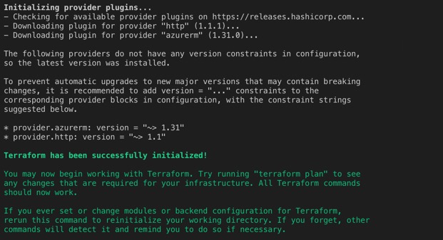
Once terraform is available locally and the deployInfo variable map has been completed, the first step in deploying infrastructure is to initialize terraform. This can be accomplished by navigating to the directory in which you have saved the above template with the .tf file extension and running the following command, which will prepare various local settings and data that will be used by subsequent commands.

terraform init

The output from initializing terraform will resemble the following.

With terraform successfully initialized, the next step in the process is to have terraform review the template and determine what changes need to take place. This step will have terraform compare the template with the current state file and produce an output showing the deltas as follows. To do so, use the following command.

terraform plan

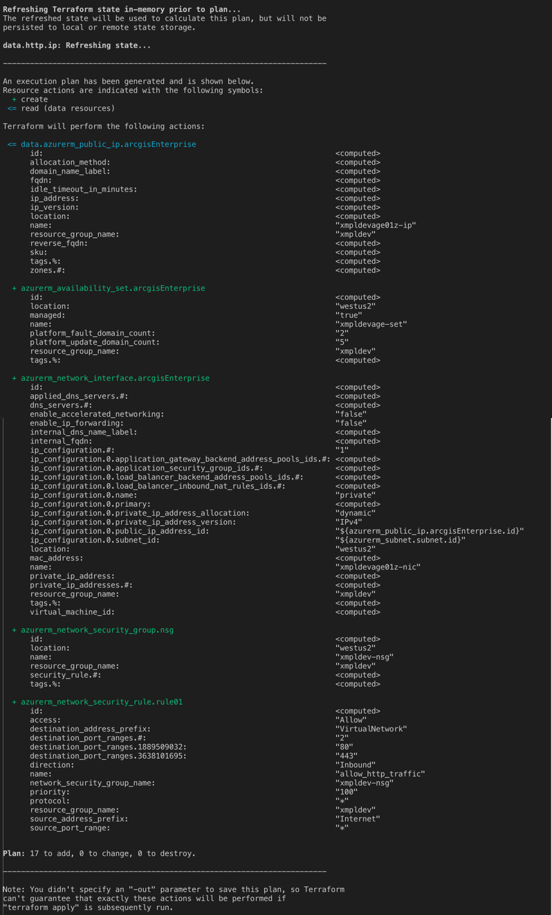
Output has been truncated.

As this is the first run of terraform, terraform is only able to see resources it needs to add (create). Later in this post, we will walk through updating existing resources.

With terraform successfully prepared to deploy our infrastructure, we can being the deployment by using the following command which will start the process of creating the resources within Azure and provide the following output when complete.

terraform apply

Updates

As the deployment is utilized, it may be determined that the current infrastructure is not adequately sized and resources need to be increased. As our resources are defined as code, so is the virtual machine sizing. Within the "arcgisEnterpriseSpecs" variable map, a variable is defined with the name "size" which is the Azure machine sizing that is used by terraform when deploying resources.

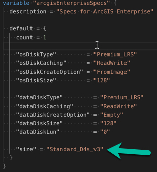
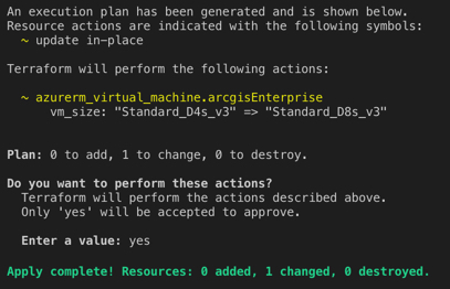
If this variable is changed to "Standard_D8s_v3" and terraform plan is ran again, it will detect a delta between what is defined in code and what is actually deployed within Azure and present this in the output as such.

Once this delta is planned and the changes are ready to be pushed to the actual infrastructure within Azure, simply running terraform apply again will begin the process.
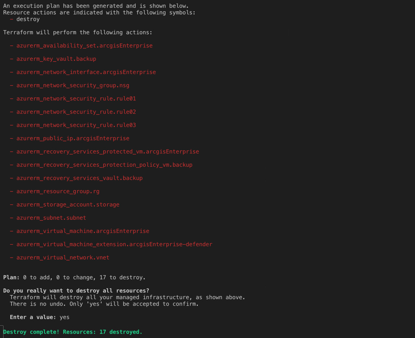
Decommission

The last phase of a given deployments life-cycle is decommissioning. Once infrastructure has reached the end of it life, it must be terminated and removed and thankfully, terraform provides an easy method to do so with the following command.

terraform destroy

The output of destroying the infrastructure will resemble the following.

In conclusion, as teams aim to become more agile and move at a much faster pace, moving to modern methodologies such as infrastructure as code (IaC) is a great first step and should not be viewed as unnecessary but a crucial step in the right direction.

I hope you find this helpful, do not hesitate to post your questions here: https://community.esri.com/community/implementing-arcgis/blog/2019/07/03/engineering-arcgis-series-t... 


Note: The contents presented above are examples and should be reviewed and modified as needed for each specific environment.

more
7 1 6,044
SridharKarra
Esri Contributor

The Managed Cloud Services team in Professional Services is pleased to announce a new series that will be highlighting various tools and best practices for implementing ArcGIS Enterprise using modern methodologies.

System implementation, configuration and management of the deployment is a fun challenge, similar to Tetris. As an ArcGIS Enterprise or ArcGIS Server administrator, you are likely tasked with standing up new systems, ensuring they are configured correctly and maintaining them over time. Traditionally, these tasks were done manually where an administrator would work through procuring a new virtual machine, install the required software, work through the configuration steps needed and then ensure users were able to access it. Over time, the needs of the users may change and as such, the administrator would need to further modify the system and its software to meet those needs.

Here at Managed Services, we are faced with managing 100's of customer implementation. This series will cover best practices we developed overtime. Each entry will cover a specific aspect of automating the deployment, configuration & life-cycle management (updates, monitoring, scaling, etc) of both infrastructure and the ArcGIS suite. 

automation, devops, implementation , engineering‌, cloud‌

more
12 4 4,725
JeffDeWeese
Esri Contributor

As cloud adoption evolves from Web GIS to full GIS deployments, questions continue to be raised such as, “What about the desktops?”. That is, when moving desktops to the cloud, what technologies should be used to support Esri desktop GIS? The cloud offers multiple desktop options and the following will provide some high-level guidance as to how and when these technologies should be used. It is important to realize that each deployment is unique and deciding on which of these technologies to deploy involves multiple factors. The purpose of providing this information is primarily to share information regarding all of the potential solutions and high-lighting some of their key characteristics. However, they will not be ranked in any way as deciding on one approach over the other requires more detailed analysis and discussion based on specified requirements, costs, and constraints. Further, this list can likely be expanded but the solutions below represent the most common options that Esri has encountered. 

Note: Assuming ArcGIS Pro will be used for rendering, ArcGIS Pro requires a GPU-enabled machine type for the underlying host VM. Examples include the NVv4 for Azure and a Graphics Bundle for AWS WorkSpaces.


Virtual Machines - Azure and AWS

  • Use Case: Typically used to support administrative functions or small number of desktop users
  • Client Connectivity: Utilizes the Remote Desktop Connection client and the RDP protocol
  • User Experience: Published desktop with growing visual latency as geographic distance increases
  • Scalability: Limited due to no more than two concurrent users per VM
  • Management: Typically deployed without a base image
  • User Profiles: Locally stored per VM


Remote Desktop Services  - Azure and AWS

  • Use Case: Supporting users at scale where the users are not globally distributed
  • Connectivity: Utilizes the Remote Desktop Connection client and the RDP protocol
  • User Experience: Published desktop or apps with growing visual latency as geographic distance increases
  • Scalability: Limited for ArcGIS Pro based on the number of concurrent sessions that can share resources (e.g., GPU)
  • Management: Can be used with snapshot technology to create a base image
  • User Profiles: Roaming profile or equivalent, assuming at least two servers deployed


Citrix Virtual Apps and Desktops (XenApp) - Azure and AWS

  • Use Case: Supporting users at scale where the users could be globally distributed
  • Connectivity: Utilizes the Citrix Workspace app and the HDX protocol
  • User Experience: Supports both published desktops and apps and performs well with high-latency
  • Scalability: Limited for ArcGIS Pro based on the number of concurrent sessions that can share a GPU
  • Management: Can be used with snapshot technology to create a base image
  • User Profiles: Roaming profile or equivalent, assuming at least two servers deployed
  • Other: Can utilize Citrix Cloud to manage the "back-end" (e.g., Controllers/Licensing)


Amazon WorkSpaces - AWS

  • Use Case: Supporting users at scale
  • Connectivity: Utilizes either a desktop or web client with either the PCoIP or WSP protocol
  • User Experience: Supports a published desktop to an assigned WorkSpace instance
  • Scalability: Can scale as needed as users increase but is 1:1 user to VM assignment
  • Management: Cannot be used with snapshot technology so each WorkSpace is an independent deployment
  • User Profiles: Locally stored on each WorkSpace


Amazon AppStream 2.0 - AWS

  • Use Case: Supporting user applications at scale
  • Connectivity: Utilizes either a desktop or web client with the NICE DCV protocol
  • User Experience: Supports published desktop applications
  • Scalability: Can scale as needed as back-end infrastructure capacity is managed by AWS
  • Management: Based on creating base images for different application configurations as needed
  • User Profiles: Saved to a Virtual Hard Disk (VHD) and synchronized to Amazon S3
  • Other: Esri / AWS AppStream 2.0 Deployment Guide


Azure Virtual Desktop - Azure

  • Use Case: Supporting users at scale
  • Connectivity: Utilizes the Remote Desktop Connection client and the RDP protocol
  • User Experience: Supports a published virtual desktop
  • Scalability: Can scale as needed assigning users to virtual desktops
  • Management: Can be used with snapshot technology to create a base image
  • User Profiles: Roaming profile or equivalent, assuming at least two servers deployed (e.g., vie FSLogix)
  • Other: The only solution supporting multi-session Windows 10/11


more
8 4 5,844
MichaelGreen
Esri Contributor

There are many impactful change management components that can increase a technology solutions’ adoption rate among users.  People coming to UC get excited about so many new capacities or expanded utilization of their platform that will bring value to their organization.  Leverage these components to increase your success rate:

  • Preparing for Change is a strategic activity that should happen at the beginning of each project where you create strong alignment between people, the goals of the project, and the sponsors who will advocate for the technology’s use. 
  • Managing Change is a series of initiatives that are integrated into your project plan to assist people in accepting and embracing the new capabilities or workflows of each project. 
  • Reinforcing Change is the best practice to cement the new workflows into an everyday routine.  People interacting with technology brings your geospatial efforts to fruition. 

Come by the Guiding Your Geospatial Journey area to talk with experts about people focused change management activities that can enhance and increase your technology adoption rates.  Additionally, here are several people-oriented sessions that are happening at UC:

Technical Workshops

Tuesday, July 9                                                                                                         Location: SDCC - Rooms

8:30 am

Helping the Workforce Survive and Thrive in Times of Technology Change

SDCC, Room 16 A

Wednesday, July 10                                                                                         Location: SDCC - Rooms

8:30 am

Get the C-Suite’s Attention with Strategic Workforce Planning

SDCC, Room 31 A

1:00 pm

Increase GIS Adoption the Agile Way

SDCC, Ballroom 06 F

2:30 pm

Workforce Development Planning in Three Simple Steps

SDCC, Ballroom 06 F

4:00 pm

Helping the Workforce Survive and Thrive in Times of Technology Change

SDCC, Room 10


Spotlight Talks                                               

Tuesday, July 9                             Location: SDCC – Expo: Guiding Your Geospatial Journey Spotlight Theater      

10:30 am

Making It Real: Use Training to Make Your Tech Dreams Come True


Wednesday, July 10                          Location: SDCC – Expo: Guiding Your Geospatial Journey Spotlight Theater      

4:00 pm

Focus on Training to Go the Distance


Expo Area

Stop by to connect 1-on-1 with Esri Staff and talk more about Change Management and Adoption Strategies in our Guiding Your Geospatial Journey area.

Tuesday, July 9                9:00 AM–6:00 PM

Wednesday, July 10        9:00 AM–6:00 PM

Thursday, July 11             8:00 AM–4:00 PM

more
2 0 1,032
JeffDeWeese
Esri Contributor

As the Esri platform continues to evolve, it is critical that organizations maintain a capable GIS system architecture that will support new GIS/IT capabilities and scale to support growing user demand. There are further key considerations that we have seen most recently such as moving to the cloud, migrating to ArcGIS Pro, and expanding the adoption of GIS capabilities within the organization. Esri Architects can work with you to understand your organization’s needs and provide guidance. We will be available at UC2019 at the Guiding Your Geospatial Journey area of the Esri Showcase and participating in several sessions throughout the conference. Meanwhile, have a look at the Architecture and Security section of GeoNet where you will discover valuable information related to GIS system architecture!

Technical Workshops

Tuesday, July 9                                                                                                         Location: SDCC - Rooms

8:30 am

Esri Best Practices: Architecting Your ArcGIS Implementation

SDCC, Room 33 C

8:30 am

Moving to a Managed Cloud Services Environment

SDCC, Room 30 A

Wednesday, July 10                                                                                         Location: SDCC - Rooms

8:00 AM

Designing an Enterprise GIS Security Strategy

SDCC, Room 30 A

1:00 pm

Moving to a Managed Cloud Services Environment

SDCC, Room 31 A

4:00 pm

Esri Best Practices: Architecting Your ArcGIS Implementation

SDCC, Room 31 A


Thursday, July 11                                                                                             Location: SDCC - Rooms

10:00 am

How to be Successful with Esri Managed Cloud Services

SDCC, Room 16 A


Spotlight Talks                                               

Tuesday, July 9                             Location: SDCC – Expo: Guiding Your Geospatial Journey Spotlight Theater      

11:15 am

ArcGIS Enterprise: Architecture Best Practices


1:00 pm

ArcGIS in the Cloud


1:30 pm

Build Security into Your System


Wednesday, July 10                          Location: SDCC – Expo: Guiding Your Geospatial Journey Spotlight Theater      

10:00 am

Are You Cloud Ready?


11:15 am

Designing a Robust Environment - Workload Separation


1:30 pm

Considerations for a Highly Available Enterprise


4:30 pm

Designing a Robust Environment - Environment Isolation


5:45 pm

Distributed Web GIS - A Modern Approach to Sharing


Appointments         

Tuesday, July 9 – Thursday, July 11  Location: SDCC – Expo: Guiding Your Geospatial Journey Spotlight Theater                                             

Architecture Maturity Review

Get expert advice and feedback on your enterprise implementation, including best practices. Leave with recommendations for meeting security and architecture needs.

Schedule an appointment


Stop by to connect 1-on-1 with Esri Staff that can talk more about your system architecture plans in our Guiding Your Geospatial Journey area.

Tuesday, July 9               9:00 AM–6:00 PM

Wednesday, July 10        9:00 AM–6:00 PM

Thursday, July 11            9:00 AM–4:00 PM

more
3 0 558
MatthewErbes1
Esri Contributor

As an Esri geospatial engineer specializing in project delivery, I work with lots of different organizations as they attempt to launch a new GIS project.  At the start, organizations often have a good high-level idea of what they want, but there is a lack of clarity in the essential details required to make the technical implementation successful.  Gathering and managing requirements effectively is critical for ensuring that the expectations of stakeholders are correctly aligned with the technical implementation of the project. 

If you are starting a GIS project and don't know quite where to begin, come find me at the 2019 User Conference – I will be sharing some of my own experiences, lessons learned, and helpful strategies when it comes to gathering requirements for GIS projects.

Come participate in my Technical Workshop:

Esri Best Practices: Collect and Manage Requirements for Successful GIS Projects

Wednesday, July 10 at 1:00 PM 

SDCC, Room 30 A

more
2 0 728
124 Subscribers