Turn on suggestions
Auto-suggest helps you quickly narrow down your search results by suggesting possible matches as you type.
Cancel
Web Maps, Web Apps, Story Maps
Subscribe
17478
0
04-18-2014 12:00 AM
- Subscribe to RSS Feed
- Mark as New
- Mark as Read
- Bookmark
- Subscribe
- Printer Friendly Page
04-18-2014
12:00 AM
Web maps, web apps, story maps ... these and other new terms are frequently used in the new world of cloud based GIS. Sorting through the lexicon of any field is critical to understanding it and to teach it. What are the similarities and differences between these terms, and how does one decide when to use each of them?
All three of these terms refer to a web map dynamically stored in the cloud, or a remote server, so that the map user can interact with it in various ways. By "interact", I mean change the scale, extent, classification, or symbology, add or subtract data, filter data, analyze spatial relationships, and more. Depending on your goals, you may want to create and use one or all three of these types of maps. The way that maps are created and stored in the ArcGIS Online cloud to begin with is via a web map. Let me illustrate with an example showing a bicycling trip I took from New York City to New Jersey following one of the Association of American Geographers conferences. Upon the completion of my trip, I created a web map in ArcGIS Online showing my bicycling route, which I captured using a GPS device that I carried with me. I recorded my route as a track, and I added that track as a GPX file to ArcGIS Online. I saved the resulting map as a standard ArcGIS Online web map, which I shared with everyone so that can look at it as well, in the link above and shown below.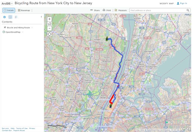
Users of your ArcGIS Online maps will not only be able to access your map as you have created it, but they can also save it into their own ArcGIS Online account and make changes to it. For example, I started with the map above and wanted to analyze the median age along my route. I easily added that layer to it and saved it as a new map.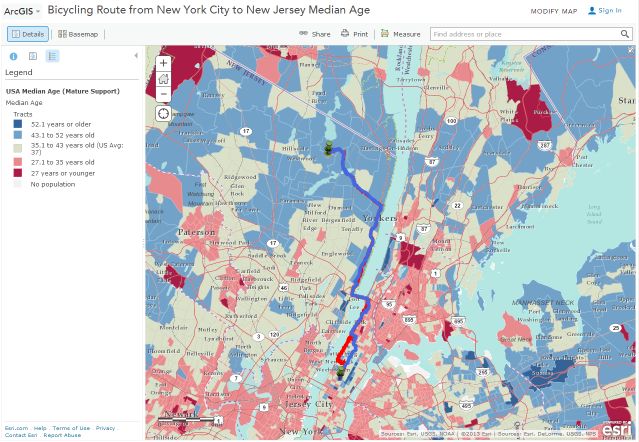
But now let's say I want to create a map with multiple panels, each showing a different map theme, or a map showing a 3D profile of my bicycling route. This is where web apps come in. A web app is an application, and ArcGIS Online provides a number of useful web app templates that you can use, or you can configure your own. I think of it this way: If you want your map user to have access to the full array of ArcGIS Online tools, publish your map as an ArcGIS Online web map. But if you want specific tools and functions to be available to your users, and you don't want them to be distracted by the other tools and functions in ArcGIS Online, then publish your map as a web app. How can you do this? When you are saving your map, simply indicate that you wish to publish to a web app, and you will be presented with a list of options.
To illustrate a web app, I created a web app from my ArcGIS Online map to show the 3D profile of my cycling route along with the median a....
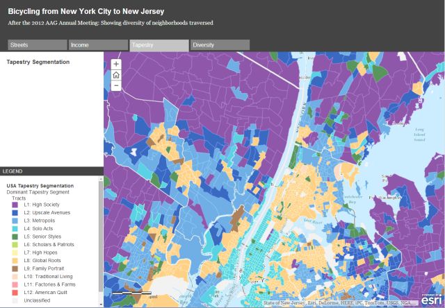
Story maps, about which we frequently write in this blog because of their great utility in education, are simply a specific type of web apps. A whole set of story map apps exist to choose from. One type of story map is a storytelling text and legend. which I used to create the story of my experience, with tabs indicating streets with my cycling route, income, tapestry lif....
Thus, it is important to think about your goals when making any map and doing any analysis. Good planning is always worth it! Web maps, web apps, and storymaps all have great utility in education. Or, to use the common vernacular, "it's all good."
All three of these terms refer to a web map dynamically stored in the cloud, or a remote server, so that the map user can interact with it in various ways. By "interact", I mean change the scale, extent, classification, or symbology, add or subtract data, filter data, analyze spatial relationships, and more. Depending on your goals, you may want to create and use one or all three of these types of maps. The way that maps are created and stored in the ArcGIS Online cloud to begin with is via a web map. Let me illustrate with an example showing a bicycling trip I took from New York City to New Jersey following one of the Association of American Geographers conferences. Upon the completion of my trip, I created a web map in ArcGIS Online showing my bicycling route, which I captured using a GPS device that I carried with me. I recorded my route as a track, and I added that track as a GPX file to ArcGIS Online. I saved the resulting map as a standard ArcGIS Online web map, which I shared with everyone so that can look at it as well, in the link above and shown below.

Bicycle Route, New York City to New Jersey, shown in ArcGIS Online.
Users of your ArcGIS Online maps will not only be able to access your map as you have created it, but they can also save it into their own ArcGIS Online account and make changes to it. For example, I started with the map above and wanted to analyze the median age along my route. I easily added that layer to it and saved it as a new map.

Bicycling Route from New York City to New Jersey with Median Age.
But now let's say I want to create a map with multiple panels, each showing a different map theme, or a map showing a 3D profile of my bicycling route. This is where web apps come in. A web app is an application, and ArcGIS Online provides a number of useful web app templates that you can use, or you can configure your own. I think of it this way: If you want your map user to have access to the full array of ArcGIS Online tools, publish your map as an ArcGIS Online web map. But if you want specific tools and functions to be available to your users, and you don't want them to be distracted by the other tools and functions in ArcGIS Online, then publish your map as a web app. How can you do this? When you are saving your map, simply indicate that you wish to publish to a web app, and you will be presented with a list of options.
To illustrate a web app, I created a web app from my ArcGIS Online map to show the 3D profile of my cycling route along with the median a....

New York City to New Jersey elevation profile, with median age, web app.
Story maps, about which we frequently write in this blog because of their great utility in education, are simply a specific type of web apps. A whole set of story map apps exist to choose from. One type of story map is a storytelling text and legend. which I used to create the story of my experience, with tabs indicating streets with my cycling route, income, tapestry lif....

Bicycling Route from New York City to New Jersey as a storymap web app.
Thus, it is important to think about your goals when making any map and doing any analysis. Good planning is always worth it! Web maps, web apps, and storymaps all have great utility in education. Or, to use the common vernacular, "it's all good."
You must be a registered user to add a comment. If you've already registered, sign in. Otherwise, register and sign in.
About the Author
I believe that spatial thinking can transform education and society through the application of Geographic Information Systems for instruction, research, administration, and policy.
I hold 3 degrees in Geography, have served at NOAA, the US Census Bureau, and USGS as a cartographer and geographer, and teach a variety of F2F (Face to Face) (including T3G) and online courses. I have authored a variety of books and textbooks about the environment, STEM, GIS, and education. These include "Interpreting Our World", "Essentials of the Environment", "Tribal GIS", "The GIS Guide to Public Domain Data", "International Perspectives on Teaching and Learning with GIS In Secondary Education", "Spatial Mathematics" and others. I write for 2 blogs, 2 monthly podcasts, and a variety of journals, and have created over 6,500 videos on my Our Earth YouTube channel.
Yet, as time passes, the more I realize my own limitations and that this is a lifelong learning endeavor: Thus I actively seek mentors and collaborators.
Labels
-
Administration
89 -
Announcements
85 -
Career & Tech Ed
1 -
Curriculum-Learning Resources
280 -
Education Facilities
24 -
Events
77 -
GeoInquiries
1 -
Higher Education
616 -
Informal Education
284 -
Licensing Best Practices
102 -
National Geographic MapMaker
39 -
Pedagogy and Education Theory
239 -
Schools (K - 12)
282 -
Schools (K-12)
302 -
Spatial data
39 -
STEM
3 -
Students - Higher Education
257 -
Students - K-12 Schools
142 -
Success Stories
44 -
TeacherDesk
1 -
Tech Tips
125
- « Previous
- Next »