Turn on suggestions
Auto-suggest helps you quickly narrow down your search results by suggesting possible matches as you type.
Cancel
- Home
- :
- All Communities
- :
- Industries
- :
- Education
- :
- Education Blog
- :
- Fostering Spatial Thinking Through Paper Maps and ...
Fostering Spatial Thinking Through Paper Maps and Aerials
Subscribe
1827
0
06-28-2017 11:21 PM
- Subscribe to RSS Feed
- Mark as New
- Mark as Read
- Bookmark
- Subscribe
- Printer Friendly Page
06-28-2017
11:21 PM
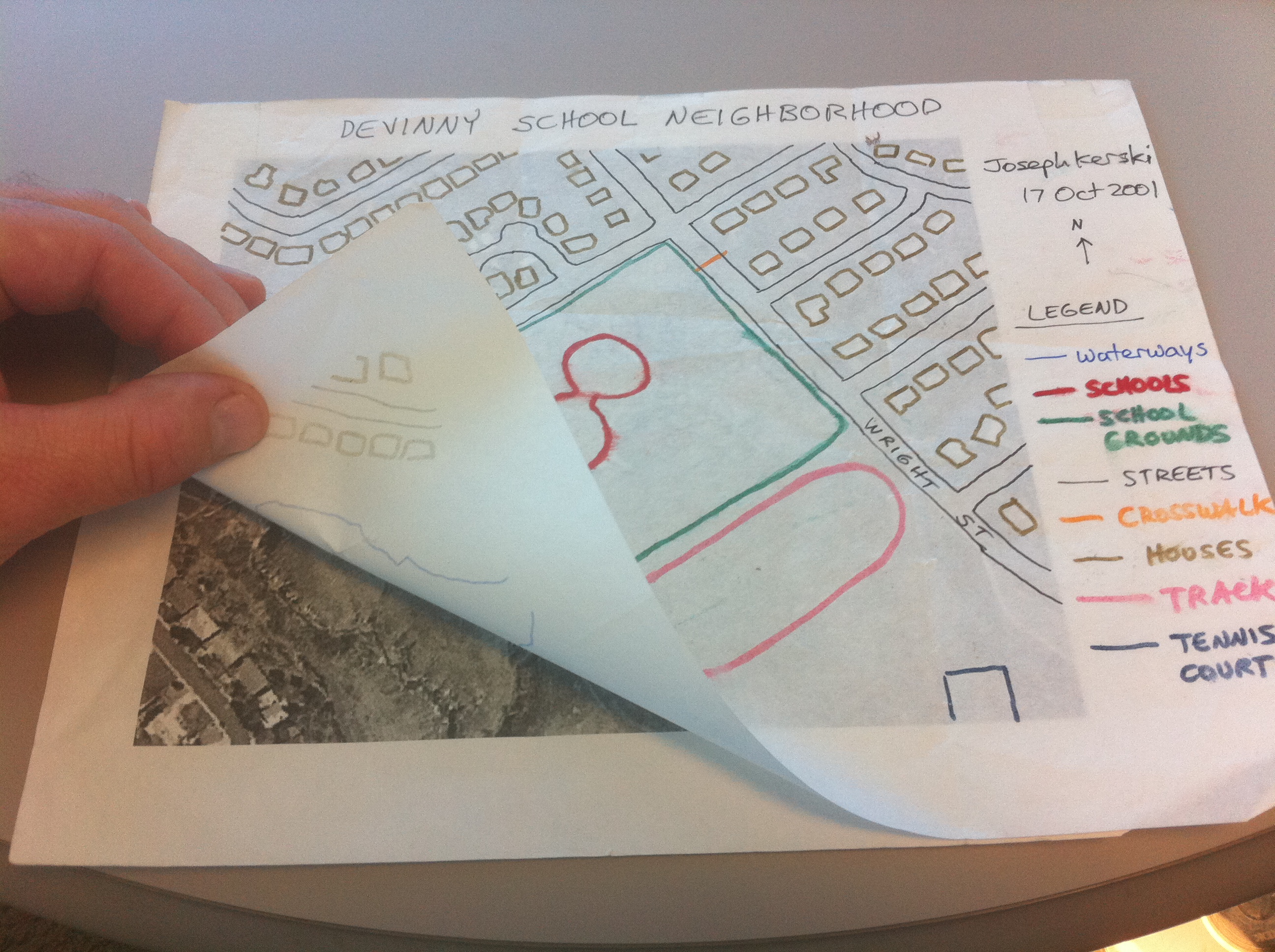
Those of us on the Esri Education Team have dedicated our careers to promoting and supporting the use of GIS and spatial thinking in education to enhance teaching and learning and to have a positive impact on society. We believe that Esri GIS tools are some of the best means available to fostering spatial thinking and prepare students for 21st Century decision making. Yet we are frequently asked what non-software activities are effective in fostering spatial thinking. Thousands indoor and outdoor activities, games, and lessons serve as excellent resources to prepare students to use GIS and also are excellent where no access to the Internet or software exists. Indeed, one of my favorite stories from the recent International Perspectives on Teaching and Learning with GIS in Secondary Schools book I co-edited came from South Africa, where students studied issues in their community and country using paper maps. I really like what my colleague David DiBiase said to the United Nations in a recent address: “The digital divide is no excuse to ignore geography.” Space doesn’t permit me to expand on the many activities based on paper maps and aerials that are suitable that I and others in the community have used for years, so let me describe just one in this essay. I have used this activity many times from age 6 to university level.

- Before you teach the lesson, access ArcGIS Online and change the base map to imagery or Bing aerial (whichever is higher resolution) and zoom the map to focus on school where you will teach this lesson. Make sure the school and the school grounds take up most of the image, but include some of the surrounding neighborhood as well.
- Print one of the aerials for each student, leaving space on the right and top for the title, legend, and other information.
- Obtain one piece of translucent paper for each aerial, and some clear tape.
- Go to the class where you are teaching with your papers and printed aerials.
- Ask the students what they think the school looks like from above. Have the students sketch the school on the white board or on paper, noting which way is north. Can they identify the cardinal directions by standing up in the classroom and pointing?
- Hand out the aerials and translucent paper. Discuss how well the aerial matches the students’ drawings on the board. What matches, and what doesn’t match, and why?
- Have the students tape the paper to the aerial along the top edge only.
- Get out colored pencils or markers. Discuss elements that are important for a good map, such as TODALSIGS – Title, orientation, date, author, legend, scale, index, grid, and source. Add name, orientation, title, scale, and source to start with.
- Discuss map themes (trees, school building, street, playground, soils, lakes and streams, and so on). Have the students choose one color for each theme for the translucent paper. Trace each theme from the aerial photo onto the translucent paper, lifting up the paper when necessary to have a clearer view of the aerial.
- Add each theme to the legend using the same color used for the theme.
- Ask students to remove the translucent paper from the aerial photo: Now they have a map! How is the map the same as the aerial image? How is it different?
What paper-based activities have you used to foster spatial thinking?
- Joseph Kerski, Esri Education Manager
You must be a registered user to add a comment. If you've already registered, sign in. Otherwise, register and sign in.
About the Author
I believe that spatial thinking can transform education and society through the application of Geographic Information Systems for instruction, research, administration, and policy.
I hold 3 degrees in Geography, have served at NOAA, the US Census Bureau, and USGS as a cartographer and geographer, and teach a variety of F2F (Face to Face) (including T3G) and online courses. I have authored a variety of books and textbooks about the environment, STEM, GIS, and education. These include "Interpreting Our World", "Essentials of the Environment", "Tribal GIS", "The GIS Guide to Public Domain Data", "International Perspectives on Teaching and Learning with GIS In Secondary Education", "Spatial Mathematics" and others. I write for 2 blogs, 2 monthly podcasts, and a variety of journals, and have created over 6,500 videos on my Our Earth YouTube channel.
Yet, as time passes, the more I realize my own limitations and that this is a lifelong learning endeavor: Thus I actively seek mentors and collaborators.
Labels
-
Administration
77 -
Announcements
80 -
Career & Tech Ed
1 -
Curriculum-Learning Resources
257 -
Education Facilities
24 -
Events
72 -
GeoInquiries
1 -
Higher Education
594 -
Informal Education
281 -
Licensing Best Practices
90 -
National Geographic MapMaker
33 -
Pedagogy and Education Theory
224 -
Schools (K - 12)
282 -
Schools (K-12)
272 -
Spatial data
35 -
STEM
3 -
Students - Higher Education
245 -
Students - K-12 Schools
128 -
Success Stories
36 -
TeacherDesk
1 -
Tech Tips
117
- « Previous
- Next »