ArcGIS API for Python Blog - Page 3

cancel
Showing results for 
Show  only  | Search instead for 
Did you mean: 

Latest Activity

(32 Posts)
by Anonymous User
Not applicable

v1.5.0 of the API is public!

Do NOT use this beta, use the public non-beta v1.5.0.The rest of this blog post is no longer relevant: Please see this blog post for more information.

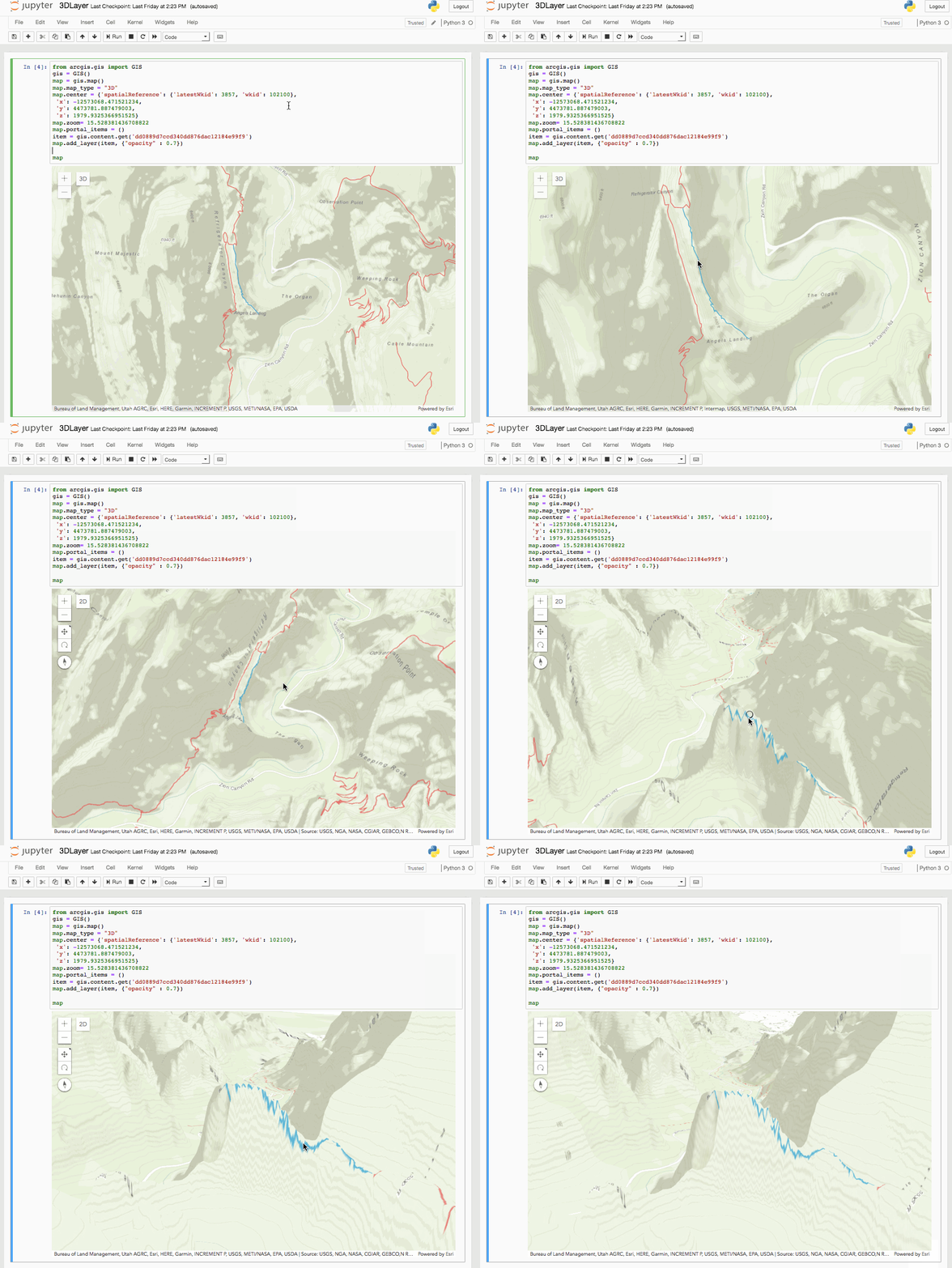
If watching today's UC Plenary inspired you to think about "What's Next?", then try downloading the new bleeding-edge beta v1.5 of the ArcGIS API for Python! This version of the API includes support for 3D Mapping, WebScenes, exporting maps to standalone HTML, and more!

To install the new beta of the API, create and activate a new conda environment by running the following:

conda create --name beta_v15

(Windows) activate beta_v15

(Unix) source activate beta_15

You can then install the beta version of the API by running the following command:

conda install -c esri/label/beta arcgis

jupyter notebook

PLEASE NOTE THAT THIS IS A BETA RELEASE. It is not as stable as v1.4.2, and should not be used in production anywhere. The API is subject to change before it's official v1.5 release.

Getting Started

The best place to get started is to view this example notebook that will walk you through all of the new features of this map widget. You can view the API reference for this new beta release here.

Let us know what you think!

Feel free to report an issue for any bugs you find in this beta release, as well as if you want to recommend features or just tell us your thoughts! We really do value your feedback, so drop us a line and let us know what you're thinking!

more
0 1 1,140
JohnYaist1
Esri Contributor

What’s new in the ArcGIS API for Python v1.4

We've released the next version of the ArcGIS API for Python - version 1.4. Click here for instructions on how to upgrade, and view the whole range of release notes.  There's a ton to be excited about it in this latest offering, and just in time for the 2018 Esri Developer Summit.  Let's highlight some of the new features so you can make the most of what this API has to offer.

You wanted the option to install the ArcGIS API for Python with pip, so we've responded and made a pip package available through PyPi, allowing you to install the API according to your needs. See the documentation here for full details on using the pip package manager to install the API, differences between installing with pip and conda, and much more! 

We've also added options to the connection experience for using your Web GIS. You now have the ability to initialize a GIS object from a token created externally. The token generated from apps or sessions elsewhere will allow you to connect with the API and access Enterprise or Organization resources.  Also upon connecting, we've enabled the persistence of profiles so that you can store your credentials locally in a secure manner and log into the GIS using the name of a profile instead of entering credentials. You're even able to store multiple profiles and use them simultaneously. Check out more details in the Guide for Working with different authentication schemes.

We're really pleased with improvements we've made to the Spatial DataFrame. Incorporation of the shapely package enhances the interoperability of the ArcGIS API for Python. Working with shapely and other geospatial data science packages like GeoPandas and fiona allows the ArcGIS API for Python to read and write almost any geospatial format on any platform. Improvements to the plotting method of the Spatial DataFrame provide an extensive range of symbology options for visualizing data with the Map widget.  We've also added upload management functionality to the Feature Layer Collection object so you have more ways to attach information where it's most useful in your GIS.  And with more functions added in the raster functions module, the future is bright for all kinds of analysis, visualization and data management with the ArcGIS API for Python.

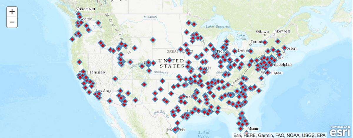
At 1.4, the API has a wider range of symbology options. Take a look:

df.plot(kind='map', 
 map_widget=m,
 colors='Reds_r',
 marker_size=10,
 outline_color='Blues',
 symbol_style='d')‍‍‍‍‍‍‍‍‍‍‍‍‍‍‍‍‍‍‍‍‍‍‍‍‍‍‍‍‍‍‍‍‍‍‍‍‍‍‍‍‍‍‍‍‍‍‍‍‍‍‍‍‍‍‍‍‍‍‍‍‍‍‍‍‍‍‍


The Python API in Jupyter notebooks is great for exploratory data analysis. You can quickly visualize data using symbology from matplotlib.

With the new graphing capability for displaying a complex raster chain analysis, you can clearly visualize your workflows:

Interested in learning and using the Python API? We encourage you to consider making it priority number one. Check out this video recording of the GeoDev Webinar Series to get a broad perspective of what you can do with the API. Also, add the ArcGIS for Developers Sample Notebooks and Dev Labs to your to-do list to inspect the capabilities of the ArcGIS API for Python for yourself.

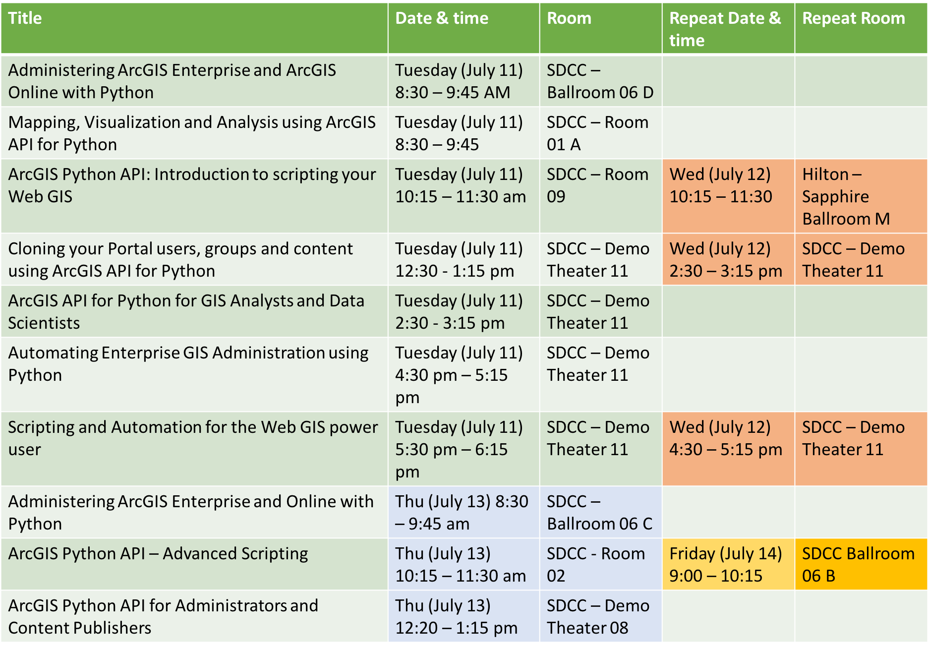
Sessions galore for you to explore at The Developer Summit in Palm Springs - We'll see you there!

Title

Date & Time

Room

Repeat Date & Time

Repeat Room

ArcGIS API for Python:

Administering Your Web GIS

Tuesday, Mar. 6

5:30 – 6:30 pm

Primrose B

Thursday, Mar. 8

5:30 – 6:30 pm

Primrose B

ArcGIS API for Python:

Introduction to Scripting Your Web GIS

Tuesday Mar. 6

1:00 – 2:00 pm

Primrose B

Thursday, Mar. 8

9:00 – 10:00 am

Primrose B

ArcGIS API for Python for Analysts and Data Scientists

Thursday, Mar. 8

4:00 – 5:00 pm

Mesquite G-H

Friday, Mar. 9

10:00 – 11:00 am

Mesquite C

ArcGIS API for Python:

Advanced Scripting

Wednesday, Mar. 7

2:30 – 3:30 pm

Catalina/Madera

Friday, Mar. 9

1:00 – 2:00 pm

Mesquite B

ArcGIS API for Python:

Mapping, Visualization, and Analysis

Thursday, Mar. 8

2:30 – 3:30 pm

Catalina/Madera


ArcGIS API for Python:

Cloning your GIS

Wednesday, Mar. 7

11:00 – 11:30 am

Demo Theatre 3:

Oasis 1-2


ArcGIS Online:

Using the Python API for Transportation Network Analysis

Thursday, Mar. 8

10:30 – 11:30 am

Santa Rosa


ArcGIS API for Python:

ArcGIS in a Notebook

Tuesday, Mar. 6

5:30 – 6:00 pm

Demo Theatre 3:

Oasis 1-2


Distributed Image Analysis Using the ArcGIS API for Python

Friday, Mar. 9

10:00 – 11:00 am

San Jacinto


more
0 0 1,270
by Anonymous User
Not applicable

We're pleased to announce that the ArcGIS API for Python is now available through pip! Pip is a package management system used to install and manage software packages written in Python, similar to conda. Many pip packages can be found in the Python Package Index (PyPI), including the ArcGIS API for Python pip package. To install the API with pip, open a terminal and enter the following command:

pip install arcgis

Pip can be configured to be a more lightweight than conda. It is often distributed with operating systems or other software, and can be installed very easily if you already have python on your computer. You can take advantage of this, for example, by installing the ArcGIS API for Python with minimal dependencies. This might be useful if you want a lightweight API to use just for administrating your GIS servers.

Pip and conda are totally separate package managers, and should avoid being used interchangeably. The API is still also available for download through conda, and it is recommended that you use conda to install the API if you are a beginner user. Read more about the differences between pip and conda here.


Click here to view the official installation guide for pip.

more
10 1 2,533
by Anonymous User
Not applicable

We are excited to announce the release of version 1.2.4 of the ArcGIS API for Python. This version includes a number of bug fixes and updated documentation. You can find the list of reported bugs addressed in the release notes.

Please upgrade your package using the command in your Anaconda shell or terminal:

conda upgrade -c esri arcgis‍‍

If this is the first time you’re installing the Python API, use the following command:

conda install -c esri arcgis‍‍

If you installed using ArcGIS Pro, you can also update your package by using the 'Update Packages' tab from the 'Python' tab in Pro backstage.

Thank you,
ArcGIS API for Python team.

more
3 2 1,383
by Anonymous User
Not applicable

We are excited to announce the v1.2.1 of the ArcGIS API for Python which includes a number of bug fixes and updated documentation for a lot of the new features introduced earlier in v1.2. You can find the list of reported bugs addressed in the release notes. This release includes documentation for building a distributed GIS using collaborationsmanaging your ArcGIS servers using Python APIadministering your ArcGIS Org / Enterprisecustomizing the appearance of your Org.

Please upgrade your package using the command in your Anaconda shell or terminal:

conda upgrade -c esri arcgis‍‍

If this is the first time you’re installing the Python API, use the following command:

conda install -c esri arcgis‍‍

If you installed using ArcGIS Pro, you can also update your package by using the 'Update Packages' tab from the 'Python' tab in Pro backstage.

Thank you,
ArcGIS API for Python team.

more
1 4 927
by Anonymous User
Not applicable

We are excited to announce the v1.2 of the ArcGIS API for Python to coincide with the Esri User Conference 2017. This is release packs a slew of new features, samples and numerous bug fixes to both the API and the samples. You can find the list of fixes and enhancements in the release notes.

Please upgrade your package using the command

conda upgrade -c esri arcgis‍‍

If this is the first time you’re installing the Python API, use the following command:

conda install -c esri arcgis‍‍

Note:

  • The v1.2 version requires Python interpreter 3.5 and later. This means, it would not work with the Python installed with ArcGIS Pro 1.3. We request our Pro users to upgrade to ArcGIS Pro 1.4 or 2.0 and reinstall the latest arcgis package.
  • If you were using v1.0 in Python 3.4 environment, please create a new environment and install either Python 3.5x or 3.6x and then install the arcgis API.

You can create a new environment in conda using the following command: In the command below, you can give a name of your choice and specify either 3.5 or 3.6 for Python version

conda create --name my_latest_python_env python=3.5‍‍

Then activate the environment and install the package using the command below:

activate my_latest_python_env
conda install -c esri arcgis‍‍‍‍‍‍

Thank you,
ArcGIS API for Python team.

more
1 12 2,524
by Anonymous User
Not applicable

We are just a few hours from Esri User Conference 2017! Below are some sessions to attend if you would like to learn more about the ArcGIS API for Python.

Python API sessions @ UC 2017

Stop by the 'Developer Expo area' at Exhibit Hall B-1 to meet the team. We will be available all week to answer your questions, learn about your workflows and requirements. Hope to meet you at the UC!

more
0 0 982
AlbertoNieto1
Esri Contributor

Jupyter Notebook is a powerful tool that allows Python users to create and share documents containing live code, visualizations, explanatory text, and equations.

The term “notebook” is very applicable, since the tool allows you to write snippets of self-contained executable code (named “cells”), note each procedure, and even visualize data you are working with at any step of the way.

Why should I use a Jupyter Notebook?

Jupyter Notebooks have gained tremendous popularity in the Python data science community over the past years for a variety of reasons. As a GIS user, I have personally found Jupyter Notebooks to be extremely useful for the following three reasons:

1. Prototyping of Python Workflows

Jupyter Notebooks are extremely useful when you do not have a defined final process and are still in the prototyping phase of your scripted workflow. This is mainly thanks to the feature where code is written into independent cells, which can each execute independently from the rest of the code. This allows a Python user to quickly test a specific step in a sequential workflow without re-executing code from the beginning of the script.

Many Integrated Development Environments (IDEs) allow you to do this in several ways, but I’ve found Jupyter Notebook’s concept of a “code cell” to be the most intuitive approach for prototyping logic and sequential code

2. Visualizing Pandas Dataframes

Pandas (Python Data Analysis Library) provides high-performing and easy-to-use data structures that allow you to work with large amounts of data extremely fast. The core data object is a Dataframe, which is essentially an in-memory table that allows powerful indexing operations.

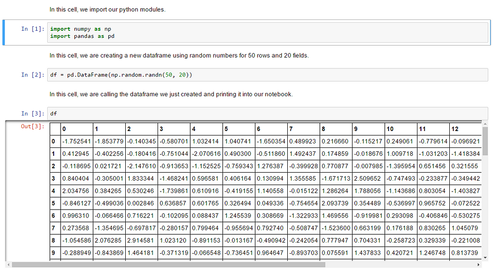
Jupyter Notebook allows you to visualize these tables at any point in your notebook. This is extremely useful because you can view the state of your data (and the effect of all the actions your code is performing on your data) as each step of your logic executes. This capability reinforces the use of Jupyter Notebook in a prototyping workflow when you are attempting to confirm that your workflow is doing what it needs to do at each step of the way.

Showing a Dataframe in a code cell can go a long way to understanding how your code operates.

So why are Pandas Dataframes such a big deal?

As a GIS user, the first foray into working with Python and GIS data management typically uses some mix of arcpy’s “CalculateField”, “SearchCursors”, and “UpdateCursors”. Most of the examples teach you to use these operations and they are all completely functional, but they suffer from the same process-intensive issue: they all need to iterate upon every record of your data to perform a data management operation.

In other words: Imagine that you are a director of a movie in production, and you find out that to change the lighting in a scene, you need to watch the movie from the very beginning… for every change. This would take forever!

Operating on a Pandas Dataframe solves for this with powerful indexing that allows effective querying and array-wide operations. You essentially find the specific scene of the movie that you need to fix, and skip to that scene. Once my GIS data analysis workflows started integrating Pandas Dataframes into heavy data operations, I saw exponential improvements in performance.

Visualizing these Dataframes and seeing the effects of my code in each dataset became a crucial component of working efficiently.

3. Integration with ArcGIS

The newest (and most exciting) reason is the integration of Jupyter Notebooks with the ArcGIS Platform. My two main production tools had long been the ArcGIS Platform and Jupyter Notebook. When Esri announced that the ArcGIS API for Python would provide support for geographic visualizations, organization administration, and even access to the most powerful analytical capabilities of the platform within Jupyter Notebooks, I literally could not stop smiling.

Seeing this for the first time made me pump my fist in the air.

The new ArcGIS API for Python renders each Jupyter Notebook an extension of your distributed GIS. Among several other capabilities, you can:

Even with all these benefits, coming up to speed with Jupyter Notebooks as a GIS user can be a daunting task. Stay tuned for a few tips on how to navigate and operate Jupyter Notebooks…

more
6 1 1,407
by Anonymous User
Not applicable

At Esri, we are very excited that despite being a relatively new product, the Python API has generated a lot of interest and adoption from our user community. When we started to design this API, one of our goals was that it should be easy enough for a beginner while being intuitive and elegant enough for a seasoned Python developer. While the API has guideAPI reference and sample notebooks, we continue to develop talks, demos and courses for it. This blog is a spot to collect and curate them.

This does not have to contain only the resources from Esri, if you delivered a talk, please share it with us or post it as a comment.

General resources

About the API in 5 minutes


Talks from Esri GeoDev Webinar 2017

On Wednesday, October 18th Ben Ramseth and Atma Mani teamed up to present the webinar, "Explore the Power of the ArcGIS API for Python". This webinar is part of the newly established GeoDev Webinar Series started by the Developer Outreach at Esri. You can find the blog post by Amy Niessen here: Questions Answered: Explore the Power of the ArcGIS API for Python and the slide deck of the recording here: https://github.com/Esri/arcgis-python-api/tree/conference_talks/talks/GeoDevWebinar2017

Talks from Esri User Conference 2017

A few of the presentations from the User Conference are available on YouTube. Below are a couple of talks on Python API:

Introduction to Scripting your Web GIS - slides and notebooks.

Administering ArcGIS Enterprise and ArcGIS Online with Python - slides and notebooks

ArcGIS Python API: Advanced Scripting - slides and notebooks

Talks from Esri Developer summit 2017

Introduction to Scripting your Web GIS - slides

Advanced scripting

ArcGIS API for Python for GIS Analysts and Data Scientists

ArcGIS API for Python for Administrators and Content Publishers - slides

Administering your Portal for ArcGIS

more
13 1 5,637
by Anonymous User
Not applicable

We are excited to announce the v1.0.1 of the ArcGIS API for Python which includes fixes for the bugs reported by you. You can find the list of fixes and enhancements in the release notes.

Please upgrade your package using the command

conda upgrade -c esri arcgis‍

If this is the first time you’re installing the Python API, use the following command:

conda install -c esri arcgis‍

Note:

  • The v1.0.1 version requires Python interpreter 3.5 and later. This means, it would not work with the Python installed with ArcGIS Pro 1.3. We request our Pro users to upgrade to ArcGIS Pro 1.4 and reinstall the latest arcgis package.
  • If you were using v1.0 in Python 3.4 environment, please create a new environment and install either Python 3.5x or 3.6x and then install the arcgis API.

You can create a new environment in conda using the following command: In the command below, you can give a name of your choice and specify either 3.5 or 3.6 for Python version

conda create --name my_latest_python_env python=3.5‍

Then activate the environment and install the package using the command below:

activate my_latest_python_env
conda install -c esri arcgis‍‍‍‍

Thank you,
ArcGIS API for Python team.

more
6 4 1,330
219 Subscribers