- Home
- :
- All Communities
- :
- Developers
- :
- Developers - General
- :
- Developers Questions
- :
- Converting VB Script for Labelling to Arcade
- Subscribe to RSS Feed
- Mark Topic as New
- Mark Topic as Read
- Float this Topic for Current User
- Bookmark
- Subscribe
- Mute
- Printer Friendly Page
- Mark as New
- Bookmark
- Subscribe
- Mute
- Subscribe to RSS Feed
- Permalink
I have the following VB Script expression for labeling hatches. It worked just fine in ArcMap. As I am now using ArcGIS Pro, I would like some help converting it to Arcade.
Function FindLabel ( esri__measure )
segLen = esri__measure
if right(int((segLen *3.2808399)),2) = 0 then
lblStation= int((segLen *3.2808399)/100) & "+00"
else
lblStation = int((segLen *3.2808399)/100) & "+" & right(int(segLen *3.2808399),2)
end if
FindLabel = lblStation
End Function
Solved! Go to Solution.
Accepted Solutions
- Mark as New
- Bookmark
- Subscribe
- Mute
- Subscribe to RSS Feed
- Permalink
Hi William Delmar ,
I was able to connect to the data and I see what you mean. The field reference I proposed has a fixed reference to the length of the line. There is a special reference that points to the measurement: $measure.
Your code would look like this:
var segLen = Round($measure * 3.2808399, 0);
return Round((segLen - (segLen % 100)) / 100, 0) + Text(segLen % 100, "+00");Resulting in:
- Mark as New
- Bookmark
- Subscribe
- Mute
- Subscribe to RSS Feed
- Permalink
Hi WDelmar ,
I think you should be able to do something like this:
var segLen = Round(LengthGeodetic($feature, 'feet'), 0);
return Round((segLen - (segLen % 100)) / 100, 0) + Text(segLen % 100, "+00");
- Mark as New
- Bookmark
- Subscribe
- Mute
- Subscribe to RSS Feed
- Permalink
Mr. Bakker,
Thank you. I will give it a try.
- Mark as New
- Bookmark
- Subscribe
- Mute
- Subscribe to RSS Feed
- Permalink
When I tried the expression, I received an error of:
Invalid expression.
Error on line 1.
Projection is invalid
I altered line 1 to read:
var segLen = Round(Length($feature, 'feet'), 0);
And it returned a result of:
Expression is valid.
When I ran the expression, my labels read all the same number. Is there a way to have the resulting number change based on the distance from the beginning of the line?
Thanks.
- Mark as New
- Bookmark
- Subscribe
- Mute
- Subscribe to RSS Feed
- Permalink
Hi William Delmar ,
Can you explain what projection your data has? You mention that all your labels read the same number. What is that number? Your original VB script used esri__measure. Is that value (attribute) available in the data in the web map? I guess you have points and want to show the measurement based on that value, right? And the value is in meters and you need to translate that to feet?
- Mark as New
- Bookmark
- Subscribe
- Mute
- Subscribe to RSS Feed
- Permalink
Can you explain what projection your data has?
They were drawn in the Projected Coordinate System: NAD 1983 UTM Zone 15N, Projection: Transverse Mercator, WKID: 26915; with Geographic Coordinate System: GCS North American 1983, WKID: 4269.
What is that number?
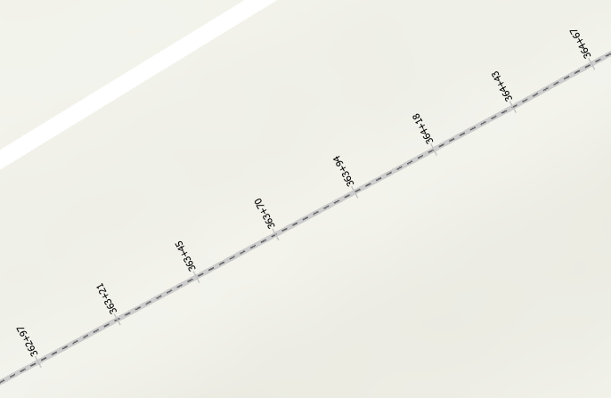
The number on the labels is 1076+61. This appears to be the total length of the line when converted into feet and further converted into a method of stationing that is used for roadways and levees.
Your original VB script used esri__measure. Is that value (attribute) available in the data in the web map?
The esri__measure is the Shape Length of the lines drawn. The data is located in the map, though not currently a web map.
I guess you have points and want to show the measurement based on that value, right? And the value is in meters and you need to translate that to feet?
I am using existing data that is centerlines for levees. We collected observations that use the measurement along this line as a reference for points and lines along the centerline.
- Mark as New
- Bookmark
- Subscribe
- Mute
- Subscribe to RSS Feed
- Permalink
Hi William Delmar ,
Is it possible to share a sample of your data? Or create a group in ArcGIS Online and invite me to that group (using xbakker@esri.co_utility_esri_co) and share the sample of the data in that group? It is so much easier if I can see and interact with the data.
- Mark as New
- Bookmark
- Subscribe
- Mute
- Subscribe to RSS Feed
- Permalink
Hi WDelmar ,
Before you share your data, could you try this:
var segLen = Round($feature["Shape__Length"] * 3.2808399, 0);
return Round((segLen - (segLen % 100)) / 100, 0) + Text(segLen % 100, "+00");- Mark as New
- Bookmark
- Subscribe
- Mute
- Subscribe to RSS Feed
- Permalink
Here is a link to the group that was created. https://arcg.is/GPKiX
Hopefully, it works.
- Mark as New
- Bookmark
- Subscribe
- Mute
- Subscribe to RSS Feed
- Permalink
Hi WDelmar ,
It seems that you shared layer package, but I think I can open it in ArcGIS Pro and publish it in my portal for the moment to understand the data you have. It seems the data source is still pointing to your SQL Server database and I don't have access to that.
Is the data stored in the Enterprise Geodatabase and you are creating a web map consuming the service?