Telecommunications Blog

cancel
Showing results for 
Show  only  | Search instead for 
Did you mean: 

Other Boards in This Place


Latest Activity

(47 Posts)
SpatialNinja
Esri Regular Contributor

To remain competitive, service providers need a modern, geospatially enabled network information management approach that delivers authoritative, actionable data, unifies network records across the enterprise, and provides a secure, scalable foundation for planning, building, operating, and growing their networks. Esri offers a comprehensive geospatial platform, ArcGIS, that enables organizations to implement modern network information management systems.

Read more...

more
4 0 149
PatrickRyan
Esri Contributor

Next week, I’ll have the opportunity to attend DTW Ignite in Copenhagen—a standout event in the telecom industry that brings together innovators, operators, and technology leaders from across the world.

What makes this year especially exciting is the work we’ve been doing as part of the Infraverse 2.0 & Beyond – Phase II Catalyst project, an open innovation initiative bringing together multiple organizations to explore the future of telecom through digital twins, AI, and advanced network intelligence.

Why This Project Matters

The Infraverse Catalyst is more than a technical demonstration—it’s a glimpse into how the telecom industry is evolving toward fully integrated, intelligent network ecosystems.

At Esri, our contribution centers on building a geospatially enabled digital twin of telecom infrastructure—a dynamic environment that brings together:

  • Reality capture (drone imagery, BIM, CAD)
  • Network data and topology
  • RF propagation and environmental context
  • Real-time and predictive analytics

Together, these capabilities create a living representation of the network that enables everything from proactive resilience planning to accelerated service restoration.

The Value of True Collaboration

One of the most rewarding aspects of this project has been the opportunity to work alongside a diverse set of partners—each bringing unique expertise in areas like RF engineering, AI, simulation, and network operations.

Catalysts are designed as open innovation environments, and this project fully embodies that. Teams from different companies, geographies, and disciplines come together around a shared vision—building something that no single organization could deliver alone.

That collaboration shows up in real ways:

  • Aligning on shared architectures and use cases
  • Integrating data and services across platforms
  • Iterating quickly through weekly working sessions
  • Challenging each other’s assumptions to improve outcomes

In my experience, this is where the real value lies—not just in the final demo, but in the collective problem-solving that happens along the way.

Bringing It to Life

To help tell this story, I created a short video that highlights Esri’s role in the project and how geospatial technology underpins the broader solution.

The video walks through how we:

  • Transform raw data into an interactive digital twin
  • Integrate network intelligence into a spatial context
  • Enable advanced modeling and simulation
  • Support automation for planning, operations, and recovery

Most importantly, it shows how all of this comes together to support better, faster decision-making across the telecom lifecycle.

I admittedly had a little too much fun making this video. I'd love your feedback.


(view in My Videos)
 

more
6 0 482
ShareUser
Esri Community Manager

To improve discoverability and ease of access to data offerings, Esri has introduced an e-commerce experience for users to purchase demographic data for the United States.  

Read more...

more
0 1 2,216
ShareUser
Esri Community Manager

Intended for database administrators as recommendations for establishing the product workspaces in an Enterprise Geodatabase (Oracle®, SQL Server®, PostgreSQL®).

Read more...

more
0 0 4,277
ShareUser
Esri Community Manager

Mapping & Charting Solutions (MCS) Enterprise Databases Best Practices

Intended for database administrators as recommendations for establishing the product workspaces in an Enterprise Geodatabase (Oracle®, SQL Server®, PostgreSQL®).

Read more...

more
1 0 47K
SpatialNinja
Esri Regular Contributor
5 0 6,491
Juan_CarlosTarazona
Esri Contributor

Esri is back as a member of the TM Forum! We are interested in understanding more about how our telecommunications community is leveraging the standards and frameworks that TM Forum offers. The goal is to look for opportunities for collaboration between the TM forum and Esri.

Read more...

more
1 0 5,881
SpatialNinja
Esri Regular Contributor

Looking to add project costing analysis and job tracking to the Communications Data Management for ArcGIS Online solution? Check out this blog to see how you can add cost analysis to your deployed Communications Data Management solution.

Read more...

more
1 5 25.6K
SpatialNinja
Esri Regular Contributor

By now, its pretty well known that the 5G technology and the spectrum frequencies being used to deliver on the promises of better wireless speeds and latency will require lots of small cells.  The amount of infrastructure being deployed to deliver 5G far exceeds previous wireless technologies, and therefore the amount of CAPEX being invested is far greater than ever before. So wireless carriers need to be more strategic in where they deploy 5G in order to get the highest ROI.  And this is where GIS can help. So in this blog I'll outline a few GIS based spatial analysis tools that can be used to optimize the locations and placement of cell sites in order to get the highest return with the least amount of CAPEX spent.

Suitability Modeler

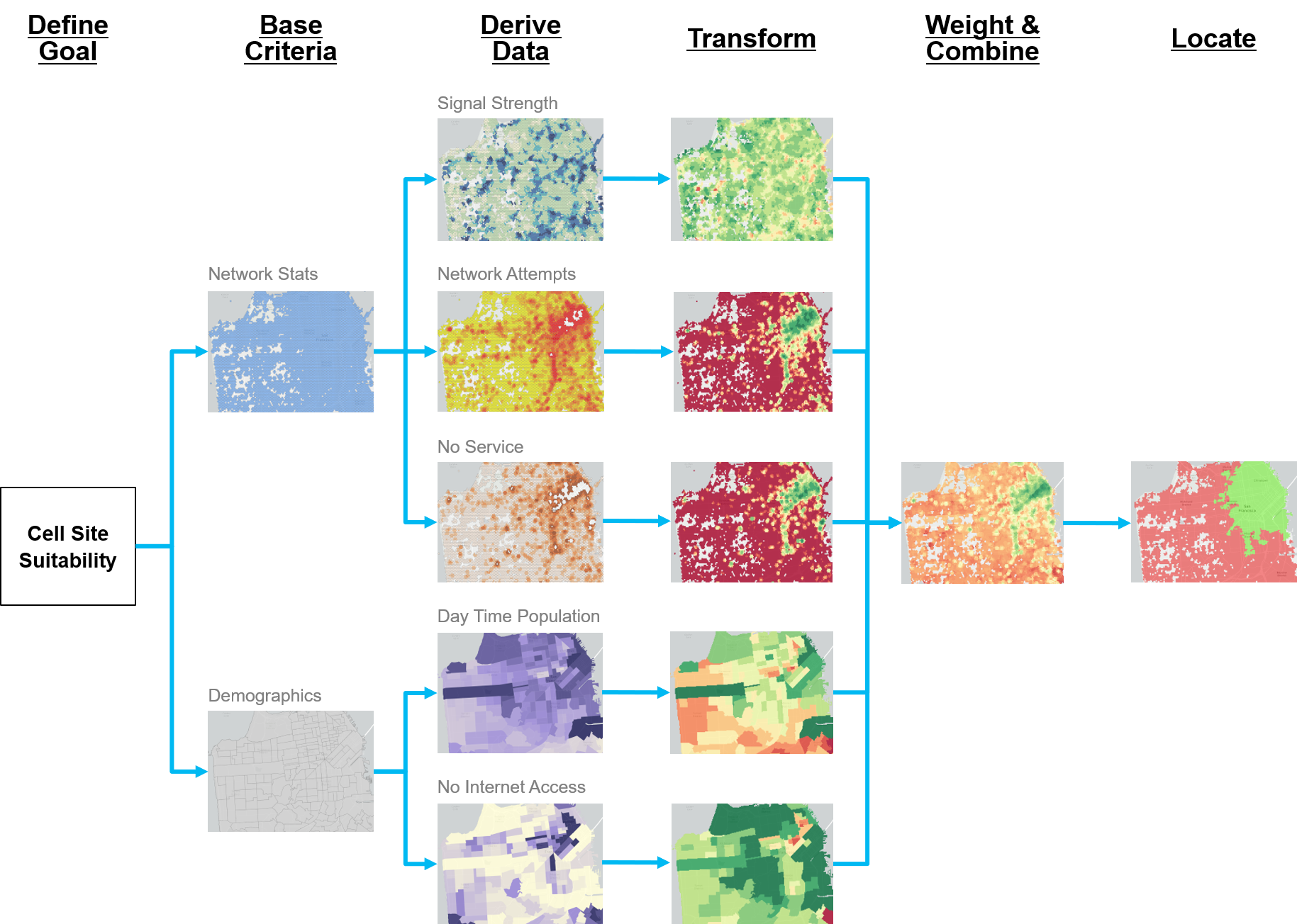
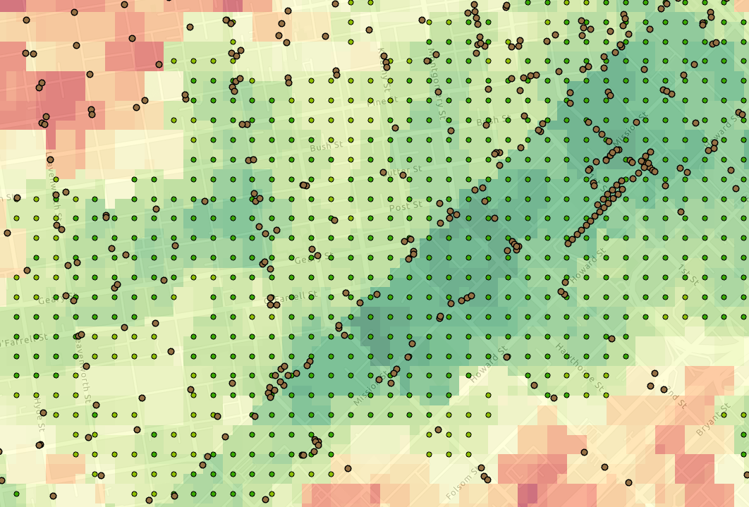
A suitability model is used to determine the best location to site things or areas to preserve, like locating the best locations to place cell sites.  The new Suitability Modeler in ArcGIS enables you to create a suitability model in an intuitive, integrated framework. The following image illustrates the sample suitability model workflow for cell site suitability:

A sample suitability modeling for cell sites is shown.

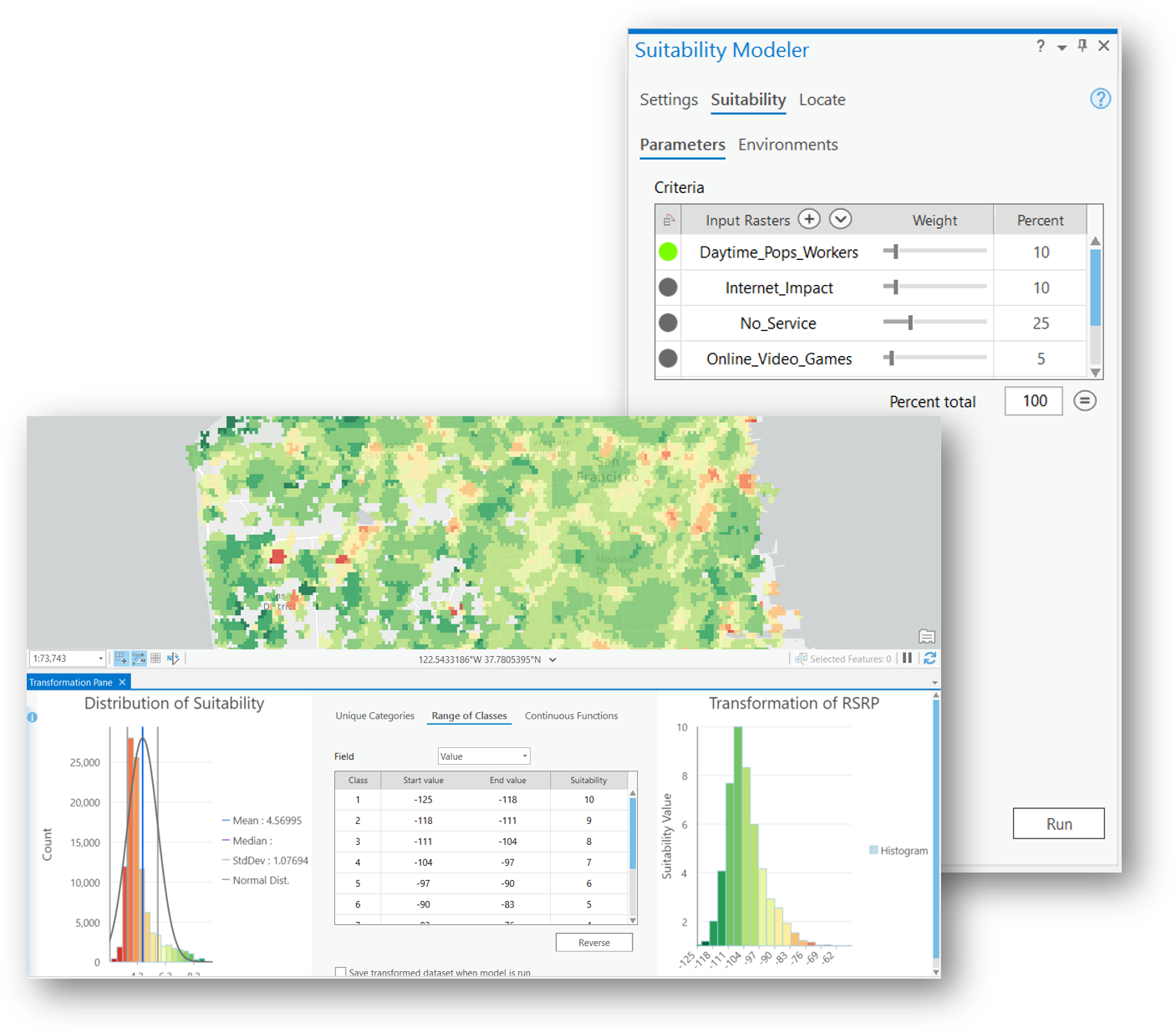
Since determining the ideal locations for a cell site can be based on multiple factors and different criteria, suitability analysis allows you to look at existing network statistics or call records as well as demographics, and weight them accordingly to come up with the best areas that address all of these variables.  The Suitability Modeler through ArcGIS Pro offers an easy to use transformation pane to reclassify and transform your input datasets, along with charts to see the distribution of your data.

The results of the suitability analysis provide you with areas that are highly suitable.  This suitability map can be used to locate structures within highly suitable areas for small cell deployment, and can also be used to optimize the location allocation of cell sites, which we'll discuss later in this blog.

Closest Facility

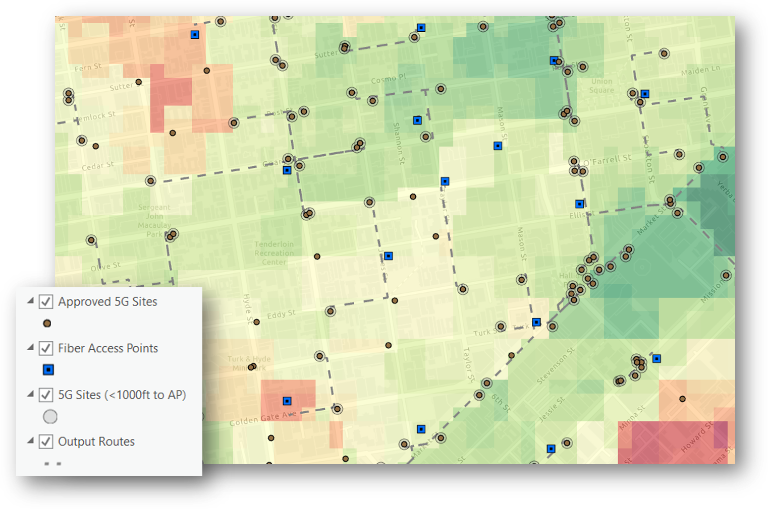
A second big driver of cell site placement is proximity to existing OSP facilities.  Traditional calculations of nearest fiber cable or network access point relied of straight line crow flies distance.  This straight line distance doesn't accurately reflect the potential path of a fiber backhaul.  The Closest Facility tool in ArcGIS allows you to calculate the street distance which more accurately represents the route a fiber cable will take.

With the Closest Facility tool, quickly locate the nearest network access points to all the potential cell site locations to calculate distance and potential cost to serve that site. 

Location Allocation

From all the candidate structure locations for a cell site that are near network access points, and that fall within our highly suitable areas, how do we then optimize which sites to build in order to cover the most area with the fewest number of cell sites? The Location Allocation tool within ArcGIS chooses the best location or locations from a set of input candidates, by assigning demand points to input candidates in a way that allocates the most demand to candidates and minimizes overall distance. This tool can be used to ensure new retail stores cover a certain market share or to evenly space out fire departments to ensure 4 min response times.  This tool can also be used to optimize the selection of cell site candidates to ensure maximum coverage with the fewest number of sites.

In the example graphic below, we've converted our high suitability areas to points which will become the demand points in the Location Allocation tool. This means we want to reach the demand points with the highest suitability score using the fewest number of cell sites within a specific radius of our sites.

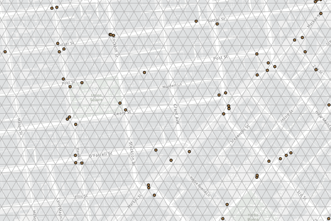
Since the the Location Allocation tool leverages a Network Dataset to calculate distance to demand points and distance between facility candidates or cell sites, we create a generic mesh network for use in the tool, shown in the graphic below.

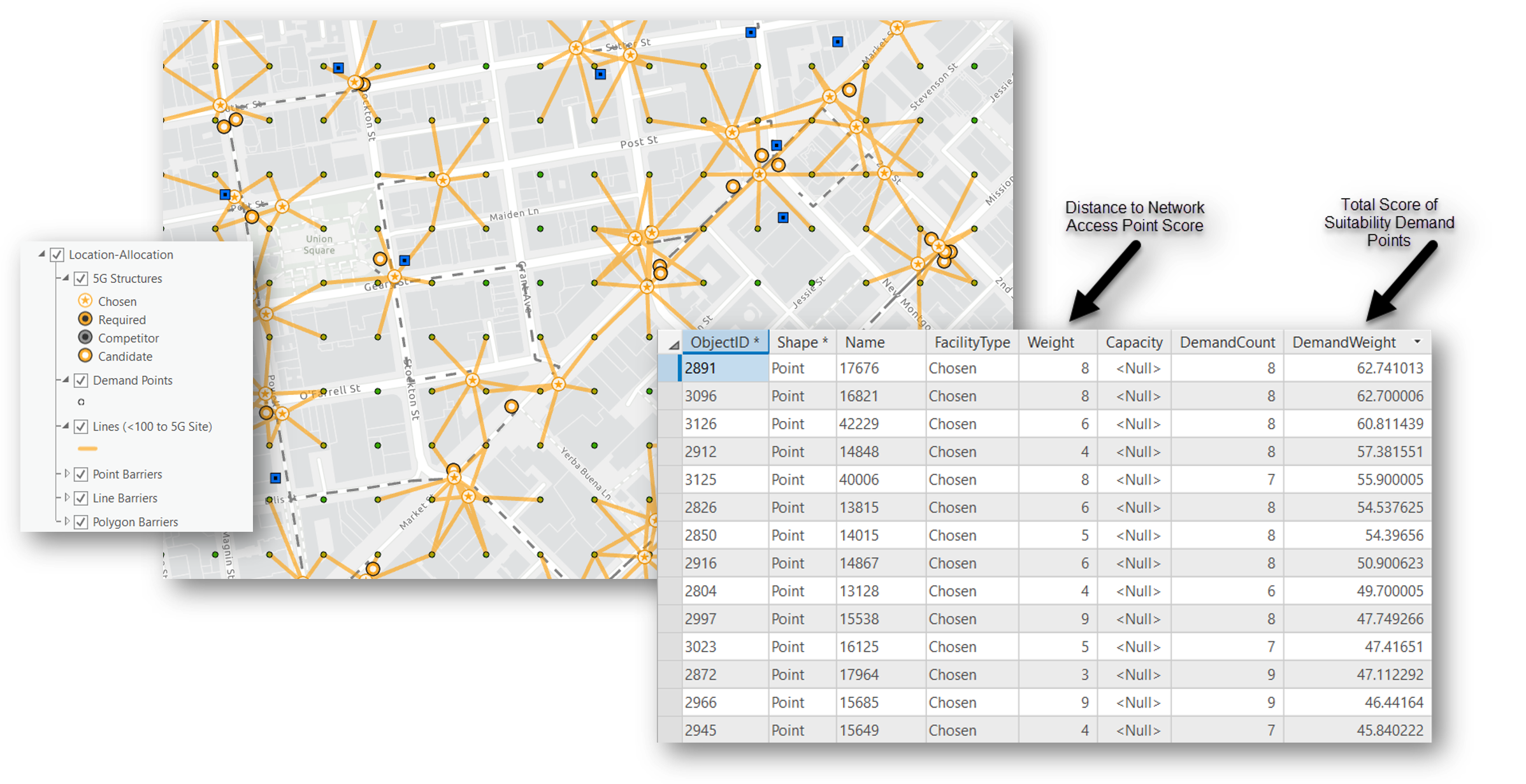
Finally, we run the Location Allocation tool using the potential cell site locations at input facilities, the suitability points as the demand points, and our mesh network as the Network Dataset.  We can also use the distance each potential cell site location is from the nearest network access point as a weight to influence the final chosen cell sites.  The suitability score of our demand points is also being used as a weight to influence the final selection. And lastly, we set a distance threshold of 100 meters for a potential cell site to reach a given demand point, which is used in lieu of a RF predicted coverage area.  The graphic below shows the final selection of cell sites and the top scored sites in the table.

Using the the 3 ArcGIS spatial analysis tools just discussed we are able to locate areas of high suitability for cell sites. Then, from a list of potential cell site structures within those suitable areas we optimized the selection of sites based on proximity to nearest network access point and greatest coverage of the suitability demand points with fewest number of sites.  Please feel free to comment or reach out to us with any questions, feedback, or ideas for improving this workflow. 

 Thanks,

- Esri Telecom Team

[email protected]

telug

more
3 0 9,629
SpatialNinja
Esri Regular Contributor

Communication networks are continually evolving, and as these complex networks evolve, planners and engineers need the proper tools to design NextGen networks as effectively and efficiently as possible.
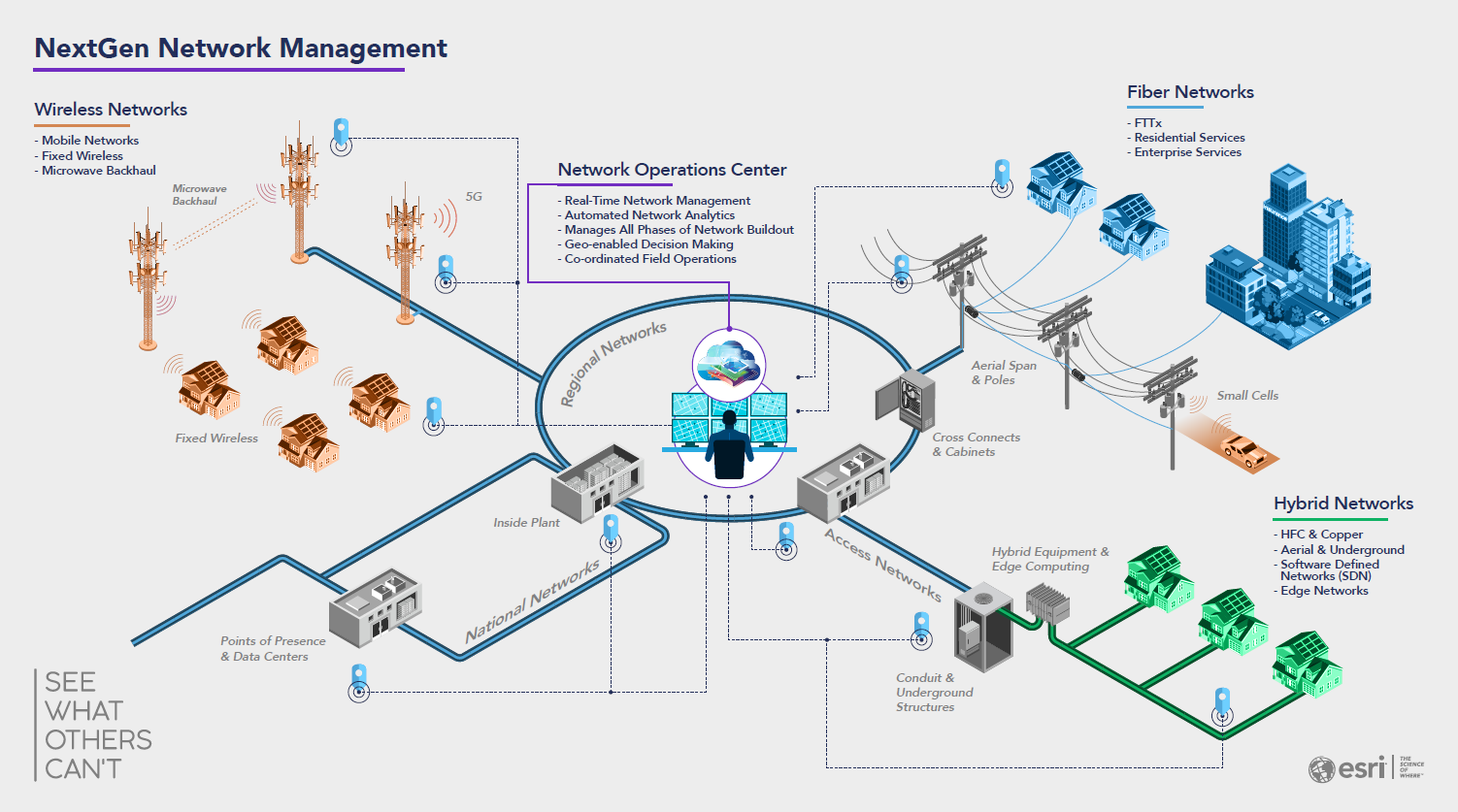


They need tools to properly design a network no matter the network technology or architecture, streamline the design through automation tools, track and manage all of the network designs supporting fiber densification and 5G build out, and easily share their designs to the field and others involved in the project. A complete GIS delivers solutions for all of these requirements, and ArcGIS is the only complete GIS designed for the telecommunications industry in mind. Let’s explore how ArcGIS can support planning and engineering NextGen communication networks.


The Project Life Cycle

The project process begins with planning and extends through high-level design, detailed engineering, and into construction. Teamwork between the office and field forces is critical to a smooth and cost-effective process. Correct as-built information feeds the organizations' sales efforts and service qualification practices. All these functions can capitalize on the same data and GIS platform: ArcGIS.

Information plays a key role throughout the entire project life cycle. ArcGIS goes beyond powerful mapping to unify the necessary data. A modern communications network is complex. Reliable engineering builds on detailed models and architecture rules of the network that reflect the real world. It relies on state-of-the-art visualization and analytics. These communicate engineering trade-offs and decisions. Designing networks that support both wireless and fixed network services demand flowing coordination and clear collaboration between departments and contractors.
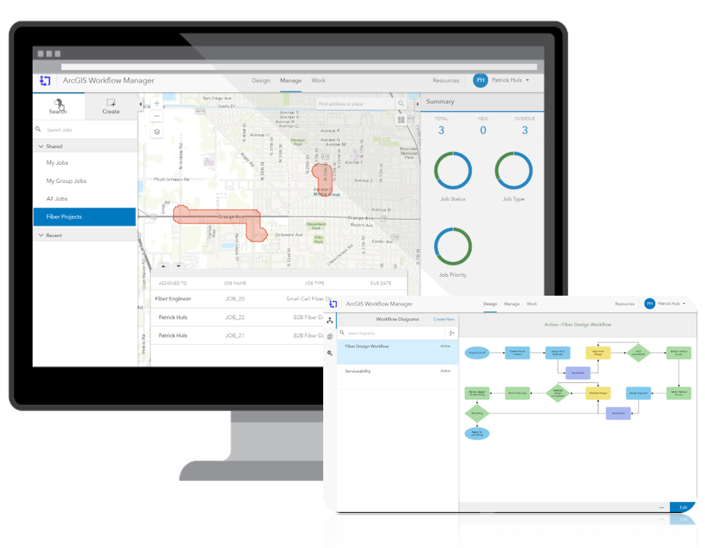
 

Ninja Pro Tip: ArcGIS Workflow Manager | Enterprise Workflow Management System 


ArcGIS allows you to easily see and track all design projects and their phases; from planning through as-built. The worst scenario that can happen is two designs occur in the same location and duplicate efforts happen that could have been avoided using a GIS based project tracking tool to easily manage and see all the projects.


High-Level Design

ArcGIS uses location technology to hone engineering work and provides an all-inclusive view of the network and its surroundings.  Bring the field to the engineer with remote engineering tools like street level imagery and access to planning datasets so that engineers can see the many factors impacting their work.
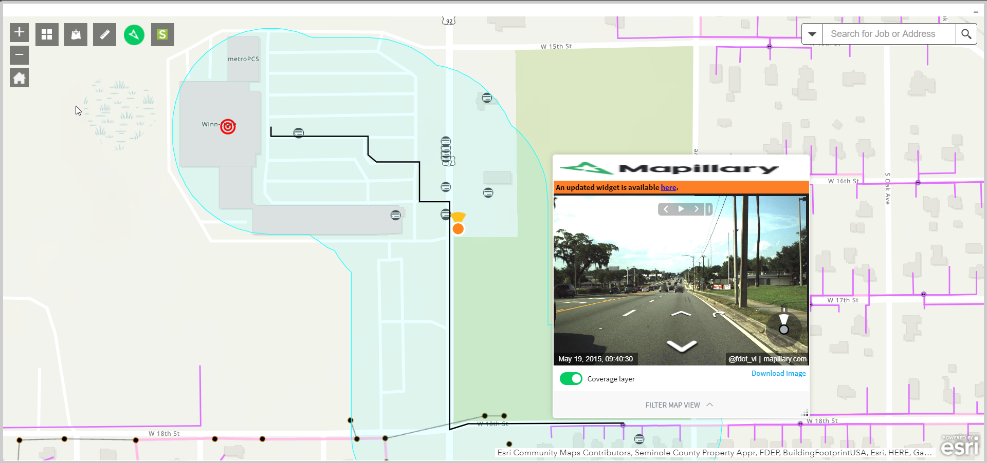
 

Compelling analytics and robust tracing actions highlight valuable insights to better understand network capacity and automate network routes. Whether its FTTx or fiber backhaul, enter in your design rules and let ArcGIS do the heavy lifting of returning a high-level design that is ready for a walkout.

(view in My Videos)

Ninja Pro Tip: Backhaul Optimization Solution Template

Detailed Engineering

The robust rule engine and framework within ArcGIS allows engineers to set up the design criteria and make changes with ease. Import architecture rules and equipment templates and lock down changes to allow for consistent network designs. As a web services platform, ArcGIS allows engineers to design from anywhere using a web or mobile app, or a traditional desktop client. 
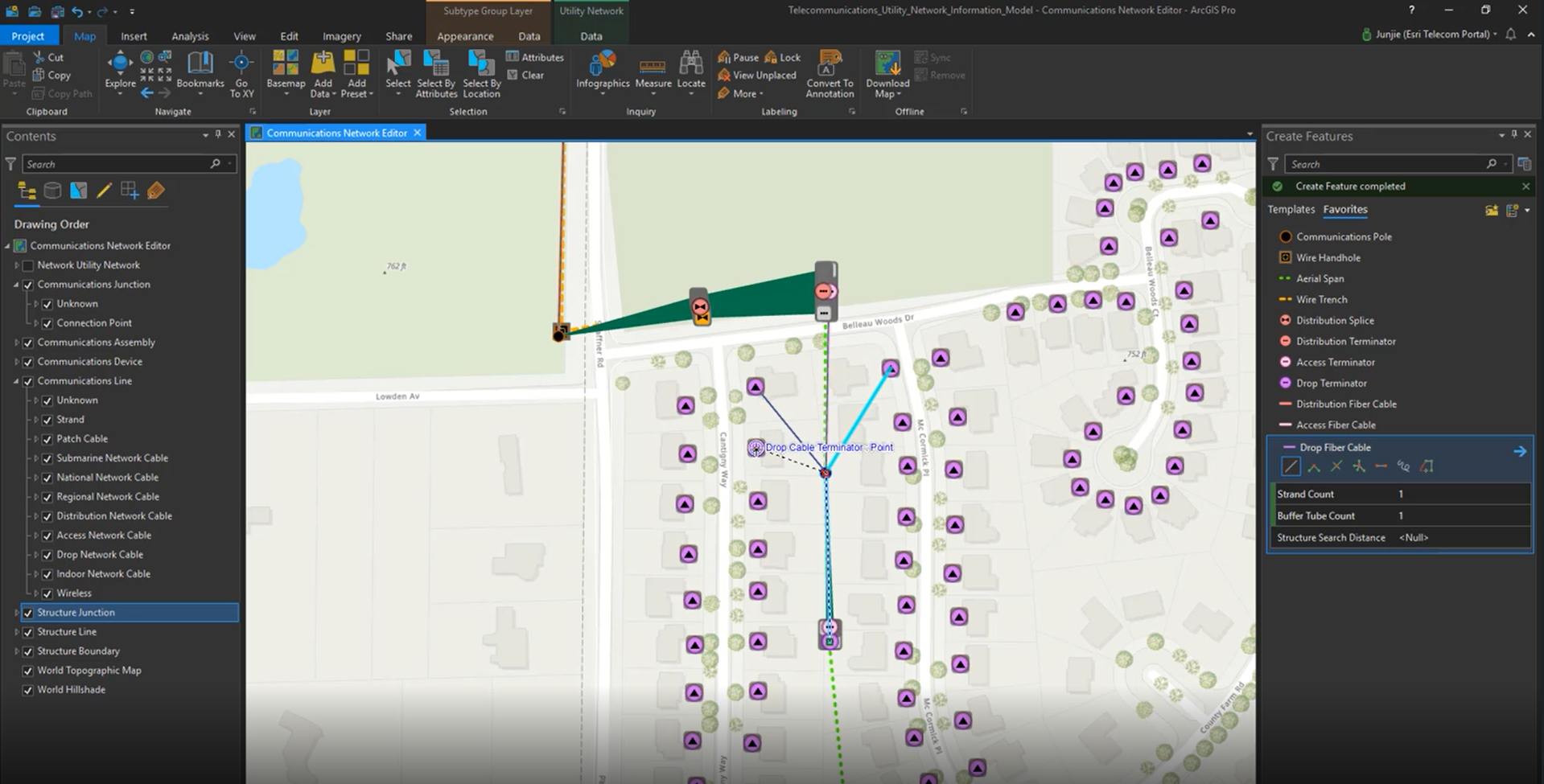
Ninja Pro Tip: Learn more about ArcGIS Utility Network Management 

Along with traditional map views, schematic views are built into ArcGIS. Engineers need to evaluate detailed design considerations. To do so, they use schematics derived from the same solid data foundation stored in the GIS. As designs are completed and ready for permitting and construction, specific equipment details exist in the context of broad, location-based information. Reliable data reinforces tools to determine material and labor estimates based on actual field conditions, and generating an accurate BOM is quick and easy.

Coordination and Collaboration

Design information must be easily accessible to those that use it. Coordination and collaboration begin with a mobile-friendly technology platform. ArcGIS uses web services to reach out across the web and put the right information into the right hands, at the right time.

Convey Projects Widely on Any Device

ArcGIS changes the way field staff connect with engineering. It distributes information, map displays, and even 3D representations on any device. It does this for the office and the field—whether connected or disconnected.

Collaborate with Internal and External Participants

Crews, contractors, and planners alike all need design information like drawings and schematics. Internal and external stakeholders also need to share project updates. ArcGIS provides all members of project teams with the flexible, role-based information products they need to work together.

Distribute Design Information Instantaneously

ArcGIS promotes common understanding by communicating project information immediately. It works at the speed of a services-based architecture. It leverages cloud computing where needed and improves situational awareness at every point along design, construction, and operations workflows.


The Complete GIS—Supporting Planning and Engineering

Most telecommunications organizations already use GIS in some capacity. Yet how they use it is changing. ArcGIS is a complete GIS, meaning that it contains all the elements needed to meet planning and engineering challenges, not just to make conventional maps.

Ninja Pro Tip: ArcGIS Solutions for Telecom - Esri: Putting the Geospatial in 5G


ArcGIS supports real-world modeling. It delivers rich visualization and analytics with artificial intelligence (AI). It enables immediate coordination and collaboration with mobile apps and web browsers. It maintains key information needed for efficient design work. It discovers hidden meaning in data and distributes insights to everyone who needs business intelligence.


These capabilities unite all the phases of planning and engineering. They combine asset details with network performance and future plans. With location as the centerpiece, a complete design picture helps improve key performance indicators and business results. Telecom organizations face considerable challenges today and will continue to do so in the future. ArcGIS brings exceptional value to every organization’s engineering, design, and construction practice.

Be sure to check out the upcoming three part webinar series on ArcGIS Utility Network Management.

-  Webinar 1 (July 😎 : 7 Steps to get started with the Utility Network - 9:00am - 10:00am

-  Webinar 2 (July 22) : The Business Value of ArcGIS Utility Network -9:00am - 10:00am

-  Webinar 3 (August 5) : Migration and Implementation to ArcGIS Utility Network - 9:00am -  10:00am

Register Today: 2020 Utility Network Webinar Series

Patrick Huls

Solution Engineer - Telecommunications

LinkedIn: Patrick Huls| Twitter: @SpatialNinja| GeoNet:Phuls-esristaff

more
1 0 7,881
106 Subscribers