- Home
- :
- All Communities
- :
- Products
- :
- Geoprocessing
- :
- Geoprocessing Questions
- :
- Re: is there any way to point and click on a map a...
- Subscribe to RSS Feed
- Mark Topic as New
- Mark Topic as Read
- Float this Topic for Current User
- Bookmark
- Subscribe
- Mute
- Printer Friendly Page
is there any way to point and click on a map and have the coordinate (lat/long) inserted at that point.
- Mark as New
- Bookmark
- Subscribe
- Mute
- Subscribe to RSS Feed
- Permalink
Is there any way to point and click on a map and have the coordinate (lat/long) inserted at that point.
Solved! Go to Solution.
Accepted Solutions
- Mark as New
- Bookmark
- Subscribe
- Mute
- Subscribe to RSS Feed
- Permalink
Steve,
As I mentioned earlier you can find the "Add XY Coordinates" tool in the Data Management > Features toolbox.
- Mark as New
- Bookmark
- Subscribe
- Mute
- Subscribe to RSS Feed
- Permalink
Steve,
What context are you talking about? ArcGIS Desktop, some Web API, ArcGIS Online?...
- Mark as New
- Bookmark
- Subscribe
- Mute
- Subscribe to RSS Feed
- Permalink
If you are talking about Javascript api @Tim Witt posted a blog about using location reverse look up.
- Mark as New
- Bookmark
- Subscribe
- Mute
- Subscribe to RSS Feed
- Permalink
In ArcGis desktop what I am trying to do is insert a coordinate (lat/long) on every township corner, I was wondering if this could be done by going to each corner and clicking to insert that coordinate.
- Mark as New
- Bookmark
- Subscribe
- Mute
- Subscribe to RSS Feed
- Permalink
Steve,
If you have a polygon that represents the townships then you can convert those to points using "Feature Vertices to Point" in the Data Management Tools > Features toolbox and then use "Add XY Coordinates" tool to the points and then label the points using the XY fields.
You can also go the route of creating a Phython tool AddIn to give you the ability to click on the map and have it add a text graphic with the XY for the mouse click location (much more involved and requires programming skills).
- Mark as New
- Bookmark
- Subscribe
- Mute
- Subscribe to RSS Feed
- Permalink
There are a few options that I can think of.
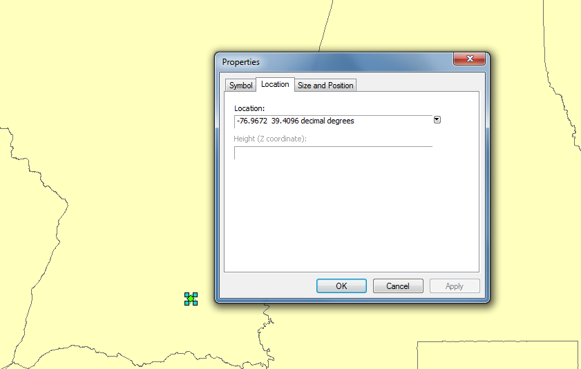
If you just need to grab a few coordinates, you can add a graphical point, double-click properties, and click the location tab. (see picture below).
If you have a lot of corners, create a point layer, and you can add the XY to all the points automatically. Then you can use this to create labels or callouts.
If you already had the coordinated of the corners in the GIS layer you could also use the Add Label tool in the Drawing toolbar.

- Mark as New
- Bookmark
- Subscribe
- Mute
- Subscribe to RSS Feed
- Permalink
Thanks everyone for your help. I'll give them a try.
- Mark as New
- Bookmark
- Subscribe
- Mute
- Subscribe to RSS Feed
- Permalink
Mara I created the point layer but not sure how to add the XY to all the points automatically, could you tell me how.
Thanks
- Mark as New
- Bookmark
- Subscribe
- Mute
- Subscribe to RSS Feed
- Permalink
Steve,
As I mentioned earlier you can find the "Add XY Coordinates" tool in the Data Management > Features toolbox.
- Mark as New
- Bookmark
- Subscribe
- Mute
- Subscribe to RSS Feed
- Permalink
Thanks Robert that worked great.
Steve