- Home
- :
- All Communities
- :
- Products
- :
- Geoprocessing
- :
- Geoprocessing Questions
- :
- Re: Help with using Geoprocessing task in JS appli...
- Subscribe to RSS Feed
- Mark Topic as New
- Mark Topic as Read
- Float this Topic for Current User
- Bookmark
- Subscribe
- Mute
- Printer Friendly Page
Help with using Geoprocessing task in JS application
- Mark as New
- Bookmark
- Subscribe
- Mute
- Subscribe to RSS Feed
- Permalink
Hi,
I am working with GP task for the first time and I am having some trouble getting it to work. I have published a synchronous GP service and I am trying to use that in a JS web application.
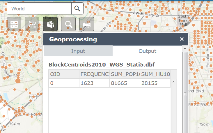
In my application all I want is a base map and I am using a map click to draw a buffer, with a user defined distance and select all the census block points that fall within that distance and output a summary of total block points, population and housing units within the buffer, I am not using a feature layer to select features or a result map service to draw the selected points on the map, but I want to use GP task to output a summary table.
What I am trying to do is, add the buffer graphics on the map and use it to input GP task result, something like in his sample which is using the user defined polygon to input the GP task, and getting a summary of population for that area.
http://developers.arcgis.com/javascript/sandbox/sandbox.html?sample=gp_zonalstats
The GP task is working fine, because I added This GP task to the geoprocessing widget in the web app builder and it is doing exactly like I want it:
I am having trouble adding it to JS application, here is a JS fiddle with what I have so far but is not working:
This is what JSON from the service looks like:
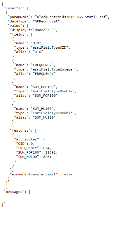
I have also attached the image of the model used to publish the service and the details from the REST service directory.
Any help will be greatly appreciated!!
Solved! Go to Solution.
Accepted Solutions
- Mark as New
- Bookmark
- Subscribe
- Mute
- Subscribe to RSS Feed
- Permalink
To convert the point you would use this:
var ptGeo = webMercatorUtils.webMercatorToGeographic(evt.mapPoint);
However, there are several other issues in the code that will also prevent it from working. I have created a modified version that uses your service and shows the results.
Please check the working example - GP Task (link removed).
The source is available from this page (link removed).
Let me know if you have questions about the code.
EDIT - the links have been removed as requested, please see the update by Saloni Rajput with the working code sections.
- Mark as New
- Bookmark
- Subscribe
- Mute
- Subscribe to RSS Feed
- Permalink
You may need to project the input point from your JS application to match the projection used in your service. From the REST service image the input point should be in Spatial Reference 102603 (3081) - Texas?
However, most ESRI web mapping applications use the spatial reference 102100 so the point you are sending to the service is most likely in the wrong coordinate system and you are getting no results.
- Mark as New
- Bookmark
- Subscribe
- Mute
- Subscribe to RSS Feed
- Permalink
Owen,
I thought the adding this to the code while a creating the GP task object should take care of the projection and match the input to the projection of the map :
gpTask.setOutSpatialReference = map.spatialReference;
Let me know if you think I still need to republish the service with SR 102100.
Thanks.
- Mark as New
- Bookmark
- Subscribe
- Mute
- Subscribe to RSS Feed
- Permalink
I think this only changes the output geometries:
setOutSpatialReference(spatialReference) NoneSets the well-known ID of the spatial reference of the output geometries.
I haven't tried using this but you may be able to use setProcessSpatialReference() to force the task to complete the analysis using the map's spatial reference.
Alternatively, I would publish the service in WGS84 and use the webMercatorUtils to convert your map point to a geographic point.
- Mark as New
- Bookmark
- Subscribe
- Mute
- Subscribe to RSS Feed
- Permalink
Owen,
Thanks again for the quick response.
So you mean that if I publish the service in WGS84 and add this, in GP task input params?
like this
param.geometries = [webMercatorUtils.webMercatorToGeographic(feature.geometry)];
and I will not have to worry about, setOutSpatialReference to map's spatial reference?
- Mark as New
- Bookmark
- Subscribe
- Mute
- Subscribe to RSS Feed
- Permalink
Owen,
I have republished the GP service in WGS84 and I have also set the out spatial reference in the model's environments settings to WGS 84.
I have added the require and function in the application but do not what is the actual code that would be needed I got this from the API reference something like this?
require(["esri/geometry/webMercatorUtils"],
function(webMercatorUtils) {var pt = Point(0, 0), // a geographic point.
result;
if (webMercatorUtils.canProject(pt, map)) {
result = webMercatorUtils.project(pt, map)
} });
Here is the updated JS fiddlle, if you could please look at that and let me know if the code looks right?
I have also updated my attachments to my original post, with new REST inputs and JSON image
Thank you!
- Mark as New
- Bookmark
- Subscribe
- Mute
- Subscribe to RSS Feed
- Permalink
To convert the point you would use this:
var ptGeo = webMercatorUtils.webMercatorToGeographic(evt.mapPoint);
However, there are several other issues in the code that will also prevent it from working. I have created a modified version that uses your service and shows the results.
Please check the working example - GP Task (link removed).
The source is available from this page (link removed).
Let me know if you have questions about the code.
EDIT - the links have been removed as requested, please see the update by Saloni Rajput with the working code sections.
- Mark as New
- Bookmark
- Subscribe
- Mute
- Subscribe to RSS Feed
- Permalink
Thanks, Owen for modifying the code and making it work. I will look at the changes.
- Mark as New
- Bookmark
- Subscribe
- Mute
- Subscribe to RSS Feed
- Permalink
Hi Owen,
I have modified the code in my application and is working now. Could you please delete the link to the URL of my service for the GP task and the source code, and I will paste the required code for others to refer.
Thanks
- Mark as New
- Bookmark
- Subscribe
- Mute
- Subscribe to RSS Feed
- Permalink
Done - can you make the relevant sections of code available on this post? Thanks.