Turn on suggestions
Auto-suggest helps you quickly narrow down your search results by suggesting possible matches as you type.
Cancel
- Home
- :
- All Communities
- :
- Products
- :
- Geoprocessing
- :
- Geoprocessing Questions
- :
- Re: creating smaller polygons inside a large polyg...
Options
- Subscribe to RSS Feed
- Mark Topic as New
- Mark Topic as Read
- Float this Topic for Current User
- Bookmark
- Subscribe
- Mute
- Printer Friendly Page
creating smaller polygons inside a large polygon automatically
Subscribe
2081
1
03-22-2014 12:57 PM
by
Anonymous User
Not applicable
03-22-2014
12:57 PM
- Mark as New
- Bookmark
- Subscribe
- Mute
- Subscribe to RSS Feed
- Permalink
Original User: jwalkerack
Hi am not sure if this is in the right place. But hopefully someone can give me some direction i am relative new to arc , so if anyone could suggest better terminology for what i am looking to do , then feel to add some comments or ideas for doing it a more effective way . thanks very much for reading
The process i am trying to get maximum coverage of building blocks within an area .
There are certain areas where the building blocks can go for example they have to be a certain distance from roads and rivers power networks and other features.
I thought the best way go about this was to merge all of these data sets together into one data set , which i ran a buffer on to give me the distance away. Once i had this i erased this from the template polygon of the area
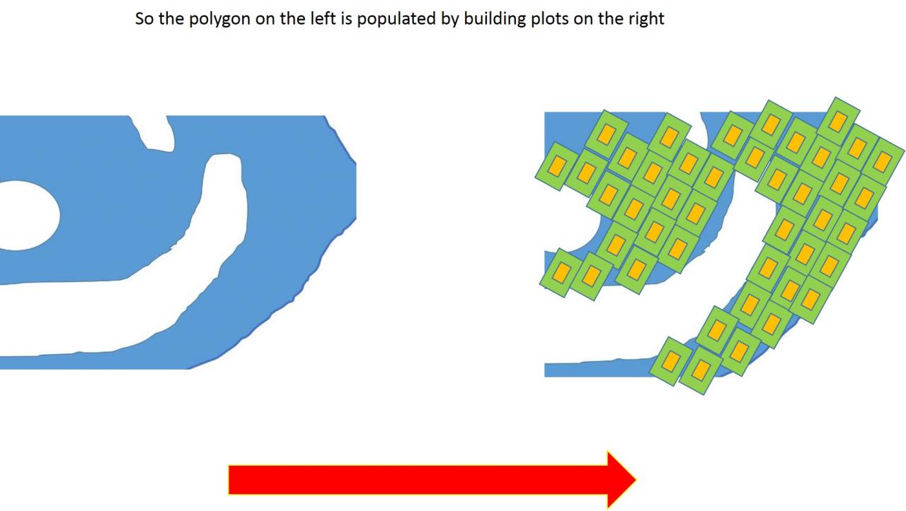
So i now i am left with a polygon where the buildings blocks could potentially go. In the attached picture all the blue areas are potential building plots areas . The white areas are non building plot areas.[ATTACH=CONFIG]32418[/ATTACH]
So at this stage i am struggling with both the concept and the process of doing this automatically as there a couple of issues
The building blocks are made up of two factors firstly the actual building . This is defined by the perimeter around the building. The second factor which makes up the building plot is the outer building. i have attached a couple picture of them here [ATTACH=CONFIG]32419[/ATTACH][ATTACH=CONFIG]32420[/ATTACH]
So it is the actual building perimeter which is important as it has to be a given distance from features. So as i mentioned before the building as to be certain distance from roads, rivers areas defined as greenbelt , brown belt etc
but it is the building + Outer building = the total building plot
coming back to my first polygon picture , the building cannot be outside the blue colored area , but the outer building area can be
[ATTACH=CONFIG]32421[/ATTACH]
i have attached another picture , showing the building plot over lapping onto the white area
you might also notice that in my pictures the building plots have a certain orientation and i would be interested to keep this
So i guess what i am looking for is a way of breaking down my polygon and filling it with these building plots
Firstly with building perimeter not crossing the boundary and then adding on my out building layer and then calculating all the potential areas
with desired result be a some thing like this
i like the computer to work out all of the areas and draw out the building plots making sure that they do not overlap and the perimeter is never overlaps the boundary , but allows for the outbuilding to over lap. I am not sure if there is an easy way of doing this , but if anyone has some ideas that would be great. Thanks very much for reading , jack
Hi am not sure if this is in the right place. But hopefully someone can give me some direction i am relative new to arc , so if anyone could suggest better terminology for what i am looking to do , then feel to add some comments or ideas for doing it a more effective way . thanks very much for reading
The process i am trying to get maximum coverage of building blocks within an area .
There are certain areas where the building blocks can go for example they have to be a certain distance from roads and rivers power networks and other features.
I thought the best way go about this was to merge all of these data sets together into one data set , which i ran a buffer on to give me the distance away. Once i had this i erased this from the template polygon of the area
So i now i am left with a polygon where the buildings blocks could potentially go. In the attached picture all the blue areas are potential building plots areas . The white areas are non building plot areas.[ATTACH=CONFIG]32418[/ATTACH]
So at this stage i am struggling with both the concept and the process of doing this automatically as there a couple of issues
The building blocks are made up of two factors firstly the actual building . This is defined by the perimeter around the building. The second factor which makes up the building plot is the outer building. i have attached a couple picture of them here [ATTACH=CONFIG]32419[/ATTACH][ATTACH=CONFIG]32420[/ATTACH]
So it is the actual building perimeter which is important as it has to be a given distance from features. So as i mentioned before the building as to be certain distance from roads, rivers areas defined as greenbelt , brown belt etc
but it is the building + Outer building = the total building plot
coming back to my first polygon picture , the building cannot be outside the blue colored area , but the outer building area can be
[ATTACH=CONFIG]32421[/ATTACH]
i have attached another picture , showing the building plot over lapping onto the white area
you might also notice that in my pictures the building plots have a certain orientation and i would be interested to keep this
So i guess what i am looking for is a way of breaking down my polygon and filling it with these building plots
Firstly with building perimeter not crossing the boundary and then adding on my out building layer and then calculating all the potential areas
with desired result be a some thing like this
i like the computer to work out all of the areas and draw out the building plots making sure that they do not overlap and the perimeter is never overlaps the boundary , but allows for the outbuilding to over lap. I am not sure if there is an easy way of doing this , but if anyone has some ideas that would be great. Thanks very much for reading , jack
1 Reply
by
Anonymous User
Not applicable
04-08-2014
01:30 PM
- Mark as New
- Bookmark
- Subscribe
- Mute
- Subscribe to RSS Feed
- Permalink
Original User: 1812
If all the builiding plots are the same size and orientation, you may get something close to what you need using the following tools:
1. Run Create Fishnet tool with the desired "cell size" (width + height); you need to understand the Y-Axis Coordinate so you can get the orientation right.
2. Run Intersect tool to intersect the fishnet polygons with your large polygons. The output may contain something close to what you need. You would need to manually move the intersected fishnet polygons for better fit.
Hope this gives you a bit help.