- Home
- :
- All Communities
- :
- Industries
- :
- Education
- :
- Education Blog
- :
- Teaching about the Ecological Land Units of the Wo...
Teaching about the Ecological Land Units of the World
- Subscribe to RSS Feed
- Mark as New
- Mark as Read
- Bookmark
- Subscribe
- Printer Friendly Page
Examining Ecological Land Units of the World. In this activity, let’s conduct a regions investigation, this time with a different definition of region: A combination of bioclimate, landforms, rock type, and land cover.
What are Ecological Land Units? Ecoregions, like cultural regions and other regions in geography, are in part a human construct—one of the techniques that we use to understand the world. The boundaries of ecoregions are not universally agreed upon, in part because they depend on what variables are used to define them, and furthermore, are usually not sharp. A new attempt to define regions is that represented by Ecological Land Units (ELUs).
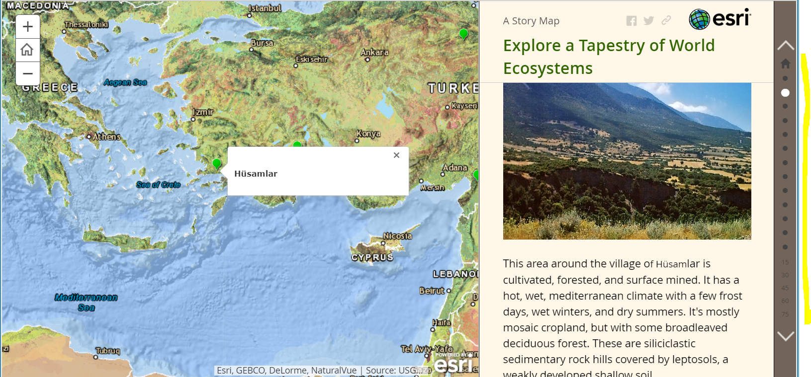
Examining Ecological Land Units via a Story Map. Access a map of ELUs here: https://story.maps.arcgis.com/apps/MapJournal/index.html?appid=dc91db9f6409462b887ebb1695b9c201&webm...
This map was produced by a team led by the US Geological Survey’s Land Change Science Program. It represents a mosaic of almost 4,000 unique ecological areas called ELUs, based on four factors that are key in determining the makeup of ecosystems. Three of these—bioclimate, landforms, and rock type—are physical phenomena that drive the formation of soils and the distribution of vegetation. The fourth, land cover, is the vegetation that is found in a location as a response to the physical factors. You can read more about the research here.
This particular type of web mapping application is called a story map. A story map can incorporate audio, video, text, photographs, charts, and interactive web maps. They can be used in education for presentation of a region, a theme, a process, or a current event, for assessing student work, and for presentation of an investigation that you or students have conducted. You will make your own story map in the next component in this module.
Use the navigation buttons on the right side of the map to move to different ELUs around the world. Select three ELUs and contrast them. How do humans use the land in each of the ELUs you chose?
Deeper Investigation into Ecological Land Units. Another way of exploring the ELUs is via this interactive web map: https://ecoexplorer.arcgis.com/. Using this map (which is another type of web mapping application), pan to Australia. When you click on a location in Australia, you will see the bioclimate, landforms, rock type, and land cover for that location. Furthermore, as you expand each of those 4 components of ELUs, you will see all of the other places in Australia and around the world where those characteristics exist. In the example below, the 4 component maps, when expanded, will show all of the locations around the planet that are warm and wet, contain high mountains, are underlain by mixed sedimentary rock, and are covered with broadleaved evergreen forests. This is an excellent tool for teaching about the complex nature of regions—how to define them, and how they are distributed across the planet. It is also an excellent tool for helping students think about “Which areas around the world are similar to my own?”, “which areas are different, and why?”
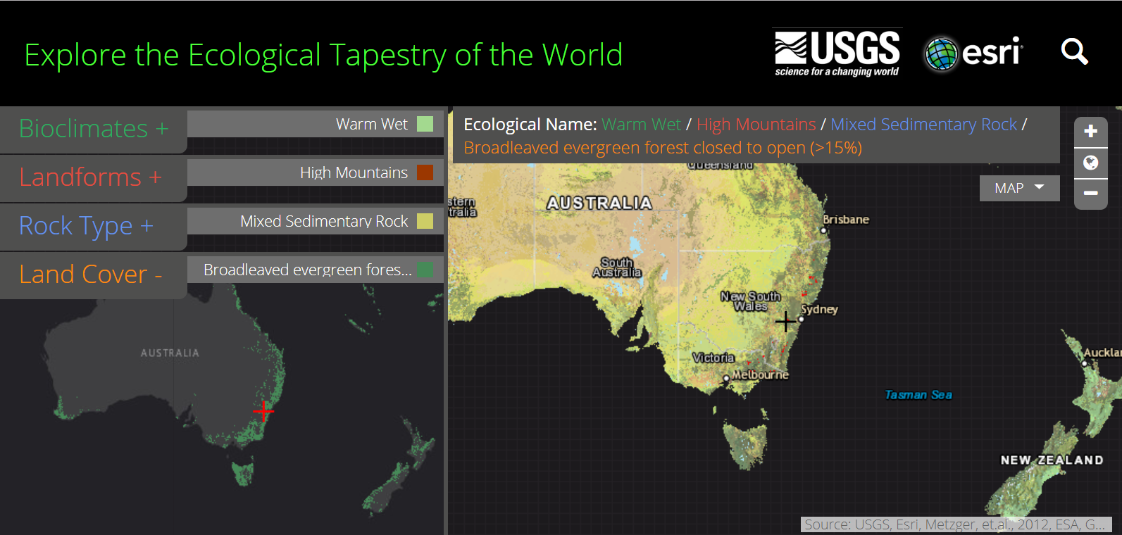
Note that you can change the basemap on the right from ecological to dark gray, imagery, or ocean, as you examine the 4 ELU components around the world on the left. Explore!
You must be a registered user to add a comment. If you've already registered, sign in. Otherwise, register and sign in.
-
Administration
79 -
Announcements
80 -
Career & Tech Ed
1 -
Curriculum-Learning Resources
259 -
Education Facilities
24 -
Events
72 -
GeoInquiries
1 -
Higher Education
597 -
Informal Education
281 -
Licensing Best Practices
92 -
National Geographic MapMaker
33 -
Pedagogy and Education Theory
226 -
Schools (K - 12)
282 -
Schools (K-12)
273 -
Spatial data
35 -
STEM
3 -
Students - Higher Education
246 -
Students - K-12 Schools
129 -
Success Stories
36 -
TeacherDesk
1 -
Tech Tips
121
- « Previous
- Next »