Turn on suggestions
Auto-suggest helps you quickly narrow down your search results by suggesting possible matches as you type.
Cancel
- Home
- :
- All Communities
- :
- Industries
- :
- Education
- :
- Education Blog
- :
- Seasonal Changes in Snow Cover Map
Seasonal Changes in Snow Cover Map
Subscribe
1767
0
02-11-2016 10:59 PM
- Subscribe to RSS Feed
- Mark as New
- Mark as Read
- Bookmark
- Subscribe
- Printer Friendly Page
02-11-2016
10:59 PM
This map in ArcGIS Online shows snow cover for the globe as it changes throughout the course of the year. The patterns the map reveals is fascinating. What is the effect of latitude on snow cover? How does snow cover in the Northern Hemisphere compare to that in the Southern Hemisphere? Which month had more snow on the ground than any other, in Canada, versus in Sweden? What is the effect of elevation on snow cover? During a specific month, which of the world's major cities had snow on the ground? Measure the extent in square kilometers for each of the months for specific countries and graph your results.
This map features NASA’s Next Generation Blue Marble imagery in a set of 12 monthly composite images of the entire earth, using 500-meter-resolution imagery from the MODIS satellite. More information is available than just the snow cover. These monthly images reveal other seasonal changes on the land surface, such as the greening up and dying back of vegetation in the temperate regions such as North America and Europe, and the dry and wet seasons in the tropics. The Blue Marble Next Generation imagery was produced by Reto Stöckli, NASA Earth Observatory (NASA Goddard Space Flight Center). The data is from 2004. For more information about this data layer, see this description. The data layer can be added to any map that you are analyzing in ArcGIS Online, and compared to other data layers, such as mean annual precipitation, or ecoregions. If you prefer to show the data as a web mapping application, see this app.
How might you use this map and its information in your instruction?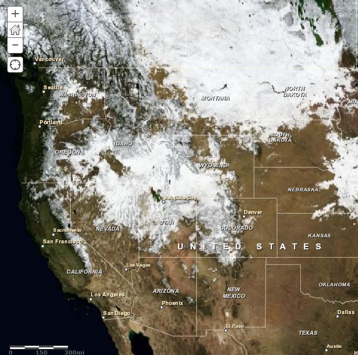
Seasonal changes map in ArcGIS Online.
Labels
You must be a registered user to add a comment. If you've already registered, sign in. Otherwise, register and sign in.
About the Author
I believe that spatial thinking can transform education and society through the application of Geographic Information Systems for instruction, research, administration, and policy.
I hold 3 degrees in Geography, have served at NOAA, the US Census Bureau, and USGS as a cartographer and geographer, and teach a variety of F2F (Face to Face) (including T3G) and online courses. I have authored a variety of books and textbooks about the environment, STEM, GIS, and education. These include "Interpreting Our World", "Essentials of the Environment", "Tribal GIS", "The GIS Guide to Public Domain Data", "International Perspectives on Teaching and Learning with GIS In Secondary Education", "Spatial Mathematics" and others. I write for 2 blogs, 2 monthly podcasts, and a variety of journals, and have created over 6,500 videos on my Our Earth YouTube channel.
Yet, as time passes, the more I realize my own limitations and that this is a lifelong learning endeavor: Thus I actively seek mentors and collaborators.
Labels
-
Administration
90 -
Announcements
88 -
Career & Tech Ed
1 -
Curriculum-Learning Resources
286 -
Education Facilities
24 -
Events
77 -
GeoInquiries
1 -
Higher Education
618 -
Informal Education
286 -
Licensing Best Practices
102 -
National Geographic MapMaker
43 -
Pedagogy and Education Theory
241 -
Schools (K - 12)
282 -
Schools (K-12)
308 -
Spatial data
39 -
STEM
3 -
Students - Higher Education
259 -
Students - K-12 Schools
147 -
Success Stories
44 -
TeacherDesk
1 -
Tech Tips
129
- « Previous
- Next »