Turn on suggestions
Auto-suggest helps you quickly narrow down your search results by suggesting possible matches as you type.
Cancel
- Home
- :
- All Communities
- :
- Industries
- :
- Education
- :
- Education Blog
- :
- Reflections on Data Interpretation and Resolution
Reflections on Data Interpretation and Resolution
Subscribe
762
0
08-17-2012 03:55 AM
- Subscribe to RSS Feed
- Mark as New
- Mark as Read
- Bookmark
- Subscribe
- Printer Friendly Page
08-17-2012
03:55 AM
One of the recurring themes in GIS education blogs, forums, listservs, conferences, and in our recent book The GIS Guide to Public Domain Data is the importance of paying attention to the characteristics of data so that correct interpretations of that data can be made when mapping that data. During some recent work with one of our favorite resources mentioned in the book, that of the Center for International Earth Science Information Network, (CIESIN), I examined a map showing the population density for central Europe (shown in image).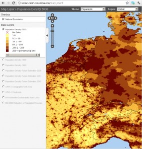
As I examined the map, population density for Germany seemed unnaturally higher than that of France. True, according to a variety of outside sources, Germany does have roughly twice the population density as does France (235 people per square kilometer for Germany versus 108 for France). But the map seemed to indicate that broad areas of Germany are even higher in density, approaching that of The Netherlands. Is this accurate?
Upon further investigation into the metadata, indeed, the resolution of the data set was to blame. CIESIN uses the highest resolution data available for generating maps like this, and the data they were able to obtain for France had a much higher resolution. The resolution is calculated as the square root of the land area divided by the number of administrative units. For Germany, it was 28, and for France, 4. The resulting population per administrative unit in 2000 was 184,000 for Germany versus only 2,000 for France. A-ha!
Close examination of the map prompted my initial concern: The areas mapped in Germany are much larger than in France. But the differences in data collection could not be confirmed until the metadata was examined. Fortunately, CIESIN does an extremely good job documenting their sources and methods. The user still needs to make it a point to read that documentation. But what should we do when working with sites that do not document their data well? In today’s world of a myriad of data, maps, and tools, it is more important than ever to have a good grounding in map interpretation and spatial analysis, but also to ask questions of the data you are using. How can we as the GIS education community foster this kind of questioning of data by our students?
- Joseph Kerski, Esri Education Manager
You must be a registered user to add a comment. If you've already registered, sign in. Otherwise, register and sign in.
About the Author
I believe that spatial thinking can transform education and society through the application of Geographic Information Systems for instruction, research, administration, and policy.
I hold 3 degrees in Geography, have served at NOAA, the US Census Bureau, and USGS as a cartographer and geographer, and teach a variety of F2F (Face to Face) (including T3G) and online courses. I have authored a variety of books and textbooks about the environment, STEM, GIS, and education. These include "Interpreting Our World", "Essentials of the Environment", "Tribal GIS", "The GIS Guide to Public Domain Data", "International Perspectives on Teaching and Learning with GIS In Secondary Education", "Spatial Mathematics" and others. I write for 2 blogs, 2 monthly podcasts, and a variety of journals, and have created over 6,500 videos on my Our Earth YouTube channel.
Yet, as time passes, the more I realize my own limitations and that this is a lifelong learning endeavor: Thus I actively seek mentors and collaborators.
Labels
-
Administration
89 -
Announcements
85 -
Career & Tech Ed
1 -
Curriculum-Learning Resources
280 -
Education Facilities
24 -
Events
77 -
GeoInquiries
1 -
Higher Education
616 -
Informal Education
284 -
Licensing Best Practices
102 -
National Geographic MapMaker
39 -
Pedagogy and Education Theory
239 -
Schools (K - 12)
282 -
Schools (K-12)
302 -
Spatial data
39 -
STEM
3 -
Students - Higher Education
257 -
Students - K-12 Schools
142 -
Success Stories
44 -
TeacherDesk
1 -
Tech Tips
125
- « Previous
- Next »