Turn on suggestions
Auto-suggest helps you quickly narrow down your search results by suggesting possible matches as you type.
Cancel
- Home
- :
- All Communities
- :
- Industries
- :
- Education
- :
- Education Blog
- :
- Land Use Change in Your Own Backyard
Land Use Change in Your Own Backyard
Subscribe
768
0
10-26-2012 01:07 AM
- Subscribe to RSS Feed
- Mark as New
- Mark as Read
- Bookmark
- Subscribe
- Printer Friendly Page
10-26-2012
01:07 AM
What sort of changes has your neighborhood, the area around your school or university campus, or even your own backyard seen over the past few years? Outside our Esri office in Colorado, a large condominium complex has been under construction for a year. Its construction invites consideration of scale, change, and geography. In my neighborhood and in yours, GIS provides an excellent toolkit to examine changes and the reasons for them.
For centuries, communities changed very little, and indeed, some communities today undergo very little change. Yet in most communities, changes in infrastructure, total population, and the makeup of that population are commonplace. In my neighborhood, the hilltop site was chosen because of the excellent views its residents will have of the Colorado Front Range. These, incidentally, were formerly enjoyed by my colleagues on the north end of our building! Regionally, construction reflects population growth fuelled by the combination of high-tech industries, including GIS, and amenities such as nearby universities, the mountains, and the climate, making Colorado one of the fastest growing states over the past half century.
One way to do this is to examine imagery in ArcGIS Online and add three types of basemaps: Bing maps aerials, the ArcGIS Online imagery, and the USGS topographic maps layer. These sources were created on different dates and thus provide an easy and rich data source with which to examine changes in local communities. Revisit a changing area often and capture and save the updated images as I did here. Toggle the layers on and off and/or adjust the transparency so that you can compare and contrast them. Combine this to population change data that is easily added in ArcGIS Online.
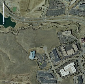
Our Esri office in Colorado in the south-central portion of this image is noticeable for its blue-ish roof. Note the open space to the north of our building.
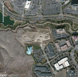
Construction has begun, but note that in addition, a large office building now appears to the north of the east-west street.
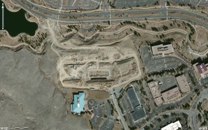
Construction proceeds. What other changes do you detect? What time of day were these images taken? What time of year were these images taken? What clues help you answer these questions?
Go outside and take pictures and videos around your local community. Write and sketch what you see. Revisit the same sites during different weather events and in different seasons, or in the case of my Esri neighborhood in Colorado, as construction progresses. Link these photographs, videos, and text to points on your ArcGIS Online maps. What changes are occurring, and why? What will your community look like and be like in 5 years? In 20 years? What can you do to influence your community in a positive way?
I invite you to use ArcGIS Online beginning with these simple but powerful ways.
- Joseph Kerski, Esri Education Manager
For centuries, communities changed very little, and indeed, some communities today undergo very little change. Yet in most communities, changes in infrastructure, total population, and the makeup of that population are commonplace. In my neighborhood, the hilltop site was chosen because of the excellent views its residents will have of the Colorado Front Range. These, incidentally, were formerly enjoyed by my colleagues on the north end of our building! Regionally, construction reflects population growth fuelled by the combination of high-tech industries, including GIS, and amenities such as nearby universities, the mountains, and the climate, making Colorado one of the fastest growing states over the past half century.
One way to do this is to examine imagery in ArcGIS Online and add three types of basemaps: Bing maps aerials, the ArcGIS Online imagery, and the USGS topographic maps layer. These sources were created on different dates and thus provide an easy and rich data source with which to examine changes in local communities. Revisit a changing area often and capture and save the updated images as I did here. Toggle the layers on and off and/or adjust the transparency so that you can compare and contrast them. Combine this to population change data that is easily added in ArcGIS Online.

Our Esri office in Colorado in the south-central portion of this image is noticeable for its blue-ish roof. Note the open space to the north of our building.

Construction has begun, but note that in addition, a large office building now appears to the north of the east-west street.

Construction proceeds. What other changes do you detect? What time of day were these images taken? What time of year were these images taken? What clues help you answer these questions?
Go outside and take pictures and videos around your local community. Write and sketch what you see. Revisit the same sites during different weather events and in different seasons, or in the case of my Esri neighborhood in Colorado, as construction progresses. Link these photographs, videos, and text to points on your ArcGIS Online maps. What changes are occurring, and why? What will your community look like and be like in 5 years? In 20 years? What can you do to influence your community in a positive way?
I invite you to use ArcGIS Online beginning with these simple but powerful ways.
- Joseph Kerski, Esri Education Manager
You must be a registered user to add a comment. If you've already registered, sign in. Otherwise, register and sign in.
About the Author
I believe that spatial thinking can transform education and society through the application of Geographic Information Systems for instruction, research, administration, and policy.
I hold 3 degrees in Geography, have served at NOAA, the US Census Bureau, and USGS as a cartographer and geographer, and teach a variety of F2F (Face to Face) (including T3G) and online courses. I have authored a variety of books and textbooks about the environment, STEM, GIS, and education. These include "Interpreting Our World", "Essentials of the Environment", "Tribal GIS", "The GIS Guide to Public Domain Data", "International Perspectives on Teaching and Learning with GIS In Secondary Education", "Spatial Mathematics" and others. I write for 2 blogs, 2 monthly podcasts, and a variety of journals, and have created over 6,500 videos on my Our Earth YouTube channel.
Yet, as time passes, the more I realize my own limitations and that this is a lifelong learning endeavor: Thus I actively seek mentors and collaborators.
Labels
-
Administration
80 -
Announcements
80 -
Career & Tech Ed
1 -
Curriculum-Learning Resources
259 -
Education Facilities
24 -
Events
72 -
GeoInquiries
1 -
Higher Education
598 -
Informal Education
281 -
Licensing Best Practices
93 -
National Geographic MapMaker
33 -
Pedagogy and Education Theory
226 -
Schools (K - 12)
282 -
Schools (K-12)
273 -
Spatial data
35 -
STEM
3 -
Students - Higher Education
246 -
Students - K-12 Schools
129 -
Success Stories
36 -
TeacherDesk
1 -
Tech Tips
121
- « Previous
- Next »