GIS and Abductive Reasoning
- Subscribe to RSS Feed
- Mark as New
- Mark as Read
- Bookmark
- Subscribe
- Printer Friendly Page
Abductive reasoning (also called abduction, abductive inference or retroduction) is a form of logical inference that goes from an observation to a hypothesis that accounts for the observation. It ideally seeks to find the simplest and most likely explanation. In abductive reasoning, unlike in deductive reasoning, the premises do not guarantee the conclusion. One can understand abductive reasoning as "inference to the best explanation". The fields of law, computer science, and artificial intelligence research have renewed interest in the subject of abduction.
Abductive reasoning can be effectively taught through spatial thinking and analysis with the use of GIS technology. Through the overlaying, swiping, symbolizing, and classification of maps and imagery in a GIS, students are encouraged to make observations about the patterns, relationships, and trends, or -- even the lack of pattern. They can then form a hypothesis about why the pattern exists and how it came to be. They can then test that hypothesis against the data, by running a set of spatial statistical techniques, by testing different models, by symbolizing and classifying the data in different ways, and by examining different regions of the world at different scales, testing whether the relationship holds in all regions and scales, or just some.
All of this is what I find most valuable about GIS: It is one of those few tools that allow for inquiry, investigation, hypothesis testing, changing the variable(s) analyzed, all in a single environment. It also, simultaneously, allows for the planning, collection, analysis, and communication of data and research with tools such as Survey123 and QuickCapture, ArcGIS Online and Pro, story maps and other web mapping applications, and operations dashboard.
Consider the example below from a GIS-based investigation: Say after observing the map that the student's hypothesis is that the savanna regime division is generally characterized by higher population densities in East Africa. Then, that student can investigate such questions as: Does the savanna suffer from biodiversity loss to a greater degree than less populous ecoregions? What are other factors that can help explain the pattern of population density in this area? At a larger scale, is population density still higher in the savanna than other ecoregions? Why or why not?
About my note above about the "lack of pattern": Oftentimes I notice when working with students that if there is no discernible geographic pattern, they think that their analysis or data are invalid. Not necessarily! When working with GIS, you are using real world data, describing real world phenomena, with all of its inherent complexities and limitations. There may be no spatial pattern to that phenomena. But that doesn't make the phenomena less interesting, relevant, or important. The lack of spatial pattern should lead you to ask additional questions!
For more, see my video. I look forward to your comments!
--Joseph Kerski
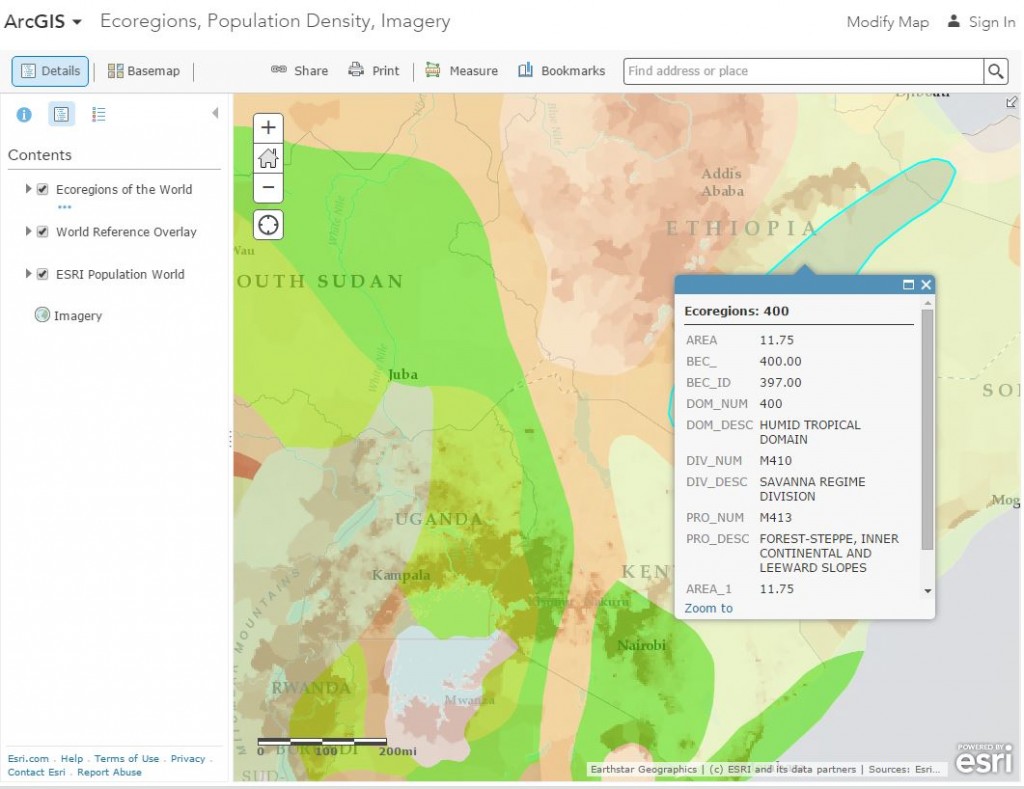
Examining ecoregions and population density in a GIS environment (ArcGIS Online).
You must be a registered user to add a comment. If you've already registered, sign in. Otherwise, register and sign in.
-
Administration
90 -
Announcements
88 -
Career & Tech Ed
1 -
Curriculum-Learning Resources
289 -
Education Facilities
24 -
Events
78 -
GeoInquiries
1 -
Higher Education
620 -
Informal Education
286 -
Licensing Best Practices
102 -
National Geographic MapMaker
44 -
Pedagogy and Education Theory
244 -
Schools (K - 12)
282 -
Schools (K-12)
312 -
Spatial data
40 -
STEM
3 -
Students - Higher Education
261 -
Students - K-12 Schools
149 -
Success Stories
45 -
TeacherDesk
1 -
Tech Tips
130
- « Previous
- Next »