Turn on suggestions
Auto-suggest helps you quickly narrow down your search results by suggesting possible matches as you type.
Cancel
- Home
- :
- All Communities
- :
- Industries
- :
- Education
- :
- Education Blog
- :
- Earth Quiz: 20 Questions about Our Planet Using Ar...
Earth Quiz: 20 Questions about Our Planet Using ArcGIS Online
Subscribe
1071
0
06-28-2017 11:37 PM
- Subscribe to RSS Feed
- Mark as New
- Mark as Read
- Bookmark
- Subscribe
- Printer Friendly Page
06-28-2017
11:37 PM
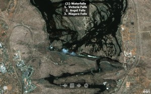
Take a look at this image. Which waterfall is shown in this image? What clues exist on the landscape to help you choose among the three options listed?

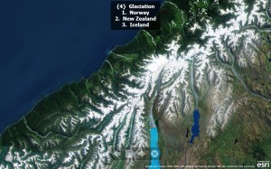
Where is this glaciated terrain located?

Examining maps and imagery seems to be an engaging activity for many people, young and old, all around the world. Consider the number of maps and images delivered daily by web GIS servers. I contend that the number requested for people who simply enjoy looking at the Earth compares favorably to the number served for wayfinding and research purposes. This interest can be effectively taken advantage in education by engaging students in a series of images or maps as a quiz or a contest. At the Esri User Conference each year, the “Where in the World” sets of imagery on display always attract a crowd.
For nearly 20 years, I have frequently used map and image quizzes in classes I have taught and presentations I have conducted for geography, environmental studies, earth science, and other classes. These quizzes can be easily created and effectively used through the use of ArcGIS Online. Using ArcGIS Online’s presentation mode, for example, I created a 20-question Earth quiz. This quiz includes the images shown above as well as waterfalls, glaciers, deserts, rainforests, volcanoes, cities, and much more.
You can view the quiz in presentation mode.
More importantly, you can also run it inside ArcGIS Explorer Online so that you will be able to change the scale and basemaps, posing and answering questions, and fostering deeper inquiry into places and the processes at work behind those places.
For example, when you engage your students in discussing glaciation using the above slide, you can zoom in to examine south versus north facing slopes and the amount of snow cover on each. You can zoom out until someone recognizes the location. Then you can discuss the effect of latitude and altitude on glaciation. You can change the basemap to topographic to determine the height of the mountains and the depth of the valleys and determine slopes. You can add land cover, climate, and population map layers and discuss how each is affected by the presence of these glaciated mountains along the west coast of this country. Thus, these are by no means static “slides” and calling them slides is really a misnomer.
Even better, instructors can create their own quizzes focused on other processes, specific themes, specific regions, or their own community. Consider a quiz-based presentation focused on a community issue such as an area proposed for rezoning, or a process such as river meanders, erosion, and sedimentation.
Well, how did you score on the 20-question Earth Quiz? How might you use the idea of an Earth Quiz in your own instruction? How might you use ArcGIS Online in your own instruction?
- Joseph Kerski, Esri Education Manager
You must be a registered user to add a comment. If you've already registered, sign in. Otherwise, register and sign in.
About the Author
I believe that spatial thinking can transform education and society through the application of Geographic Information Systems for instruction, research, administration, and policy.
I hold 3 degrees in Geography, have served at NOAA, the US Census Bureau, and USGS as a cartographer and geographer, and teach a variety of F2F (Face to Face) (including T3G) and online courses. I have authored a variety of books and textbooks about the environment, STEM, GIS, and education. These include "Interpreting Our World", "Essentials of the Environment", "Tribal GIS", "The GIS Guide to Public Domain Data", "International Perspectives on Teaching and Learning with GIS In Secondary Education", "Spatial Mathematics" and others. I write for 2 blogs, 2 monthly podcasts, and a variety of journals, and have created over 6,500 videos on my Our Earth YouTube channel.
Yet, as time passes, the more I realize my own limitations and that this is a lifelong learning endeavor: Thus I actively seek mentors and collaborators.
Labels
-
Administration
78 -
Announcements
80 -
Career & Tech Ed
1 -
Curriculum-Learning Resources
257 -
Education Facilities
24 -
Events
72 -
GeoInquiries
1 -
Higher Education
595 -
Informal Education
281 -
Licensing Best Practices
91 -
National Geographic MapMaker
33 -
Pedagogy and Education Theory
224 -
Schools (K - 12)
282 -
Schools (K-12)
272 -
Spatial data
35 -
STEM
3 -
Students - Higher Education
245 -
Students - K-12 Schools
128 -
Success Stories
36 -
TeacherDesk
1 -
Tech Tips
117
- « Previous
- Next »