Turn on suggestions
Auto-suggest helps you quickly narrow down your search results by suggesting possible matches as you type.
Cancel
- Home
- :
- All Communities
- :
- Industries
- :
- Education
- :
- Education Blog
- :
- Comparing the Spatial Distribution of Two Differen...
Comparing the Spatial Distribution of Two Different Types of Businesses in a Metropolitan Area
Subscribe
663
0
06-28-2017 11:36 PM
- Subscribe to RSS Feed
- Mark as New
- Mark as Read
- Bookmark
- Subscribe
- Printer Friendly Page
06-28-2017
11:36 PM
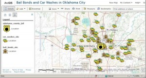
Analyzing the location of businesses is a powerful way to foster spatial thinking and skills in GIS. A new activity invites you to compare the distribution of two very different types of businesses—bail bonds and car washes, in the Oklahoma City metropolitan area.
Businesses are located in specific areas to reach specific customers locally, regionally, nationally, or internationally. They are located where they are because of physical or intangible local or regional benefits, such as a skilled labor force, the presence of or lack of competition, access to busy streets or regional transportation networks, or to take advantage of local suppliers or distributors. They are constrained in their location from local zoning laws and costs of doing business. Their locations may reveal specific patterns or exhibit no pattern at all.
This activity uses ArcGIS Online. A web browser is the only software required, with a broadband Internet connection. This lesson can be completed in 2 class periods, but additional investigations can cover multiple class periods. This lesson can be used with secondary or university level students with little or no GIS experience, but does rely upon spatial thinking and the geographic perspective.
To access the activity, visit ArcGIS Online. Search for “car wash owner:jjkerski”. Open the Oklahoma City bail bond and car wash map in the ArcGIS.com map viewer, or go directly to the map at this URL.

Compare the pattern of bail bonds and car washes and discuss the reasons these business locate where they do, and the patterns that exist. What influence does the location of the Oklahoma County detention center have on the location of the bail bond services?
Say you were establishing a new bail bonds service or car wash business. What are the three most important factors influencing your chosen location? Select the three best locations for your bail bonds and car wash businesses in Oklahoma City, and indicate the reasons why you have selected the locations you chose using the presentation mode in ArcGIS Online.
The data were gathered from an online directory, read into a comma-delimited database, and uploaded into ArcGIS Online. Using these techniques, map additional businesses in Oklahoma City, such as stores for flowers, home improvement, bicycles, boutique clothing, gas stations, and even schools or libraries. Compare and contrast the resulting patterns.
Compare the population of Oklahoma City to the population of three other cities and towns of your choosing. Conduct research into the types of businesses in those other towns. Determine how large a town has to be to support specific businesses, such as big box hardware stores, restaurant supply stores, or specific business names, such as Dairy Queen vs. Applebee’s, Ace vs. Home Depot, and the like. Why do certain businesses locate in certain sized communities? Compare bail bonds vs. car washes in different cities that have roughly the same number of people to the pattern and number you discovered in Oklahoma City. Compare the number and pattern of businesses in smaller cities and towns to that of Oklahoma City. Why do the differences exist?
Besides total population, the demographic makeup of the population is also important. These factors include household income, ethnicity, educational achievement, age, and other factors. Find and add some of these variables to your Oklahoma City map or map of another city you are investigating. What influence do these factors have on your investigated businesses? Why? Name a business, for example, where the median age of a city is important, and another business where age is not a factor. Do the same for other variables.
How has the spatial perspective and GIS helped you to understand the location of businesses?
- Joseph Kerski, Esri Education Manager
You must be a registered user to add a comment. If you've already registered, sign in. Otherwise, register and sign in.
About the Author
I believe that spatial thinking can transform education and society through the application of Geographic Information Systems for instruction, research, administration, and policy.
I hold 3 degrees in Geography, have served at NOAA, the US Census Bureau, and USGS as a cartographer and geographer, and teach a variety of F2F (Face to Face) (including T3G) and online courses. I have authored a variety of books and textbooks about the environment, STEM, GIS, and education. These include "Interpreting Our World", "Essentials of the Environment", "Tribal GIS", "The GIS Guide to Public Domain Data", "International Perspectives on Teaching and Learning with GIS In Secondary Education", "Spatial Mathematics" and others. I write for 2 blogs, 2 monthly podcasts, and a variety of journals, and have created over 6,500 videos on my Our Earth YouTube channel.
Yet, as time passes, the more I realize my own limitations and that this is a lifelong learning endeavor: Thus I actively seek mentors and collaborators.
Labels
-
Administration
65 -
Announcements
68 -
Career & Tech Ed
1 -
Curriculum-Learning Resources
233 -
Education Facilities
24 -
Events
60 -
GeoInquiries
1 -
Higher Education
566 -
Informal Education
273 -
Licensing Best Practices
75 -
National Geographic MapMaker
27 -
Pedagogy and Education Theory
209 -
Schools (K - 12)
282 -
Schools (K-12)
240 -
Spatial data
30 -
STEM
3 -
Students - Higher Education
240 -
Students - K-12 Schools
116 -
Success Stories
33 -
TeacherDesk
1 -
Tech Tips
101
- « Previous
- Next »