Turn on suggestions
Auto-suggest helps you quickly narrow down your search results by suggesting possible matches as you type.
Cancel
- Home
- :
- All Communities
- :
- Industries
- :
- Education
- :
- Education Blog
- :
- Comparing the Spatial Accuracy of Two Location App...
Comparing the Spatial Accuracy of Two Location Apps on a Smartphone in the Field
Subscribe
1249
0
01-15-2015 10:45 PM
- Subscribe to RSS Feed
- Mark as New
- Mark as Read
- Bookmark
- Subscribe
- Printer Friendly Page
01-15-2015
10:45 PM
Building on past field investigations where I studied the spatial accuracy of GPS receivers and smartphone location apps, I recently compared the spatial accuracy of two location apps on a smartphone. My goals were twofold: (1) To determine which of two location apps was more spatially accurate in varied terrain and conditions; and (2) To model a field activity that integrates geography, science, and mathematics that students can engage in easily and effectively.
On a hike in the chaparral hills of Southern California, I used my smartphone to collect my tracks using two apps--Motion X GPS and RunKeeper--at the same time. Once the hike was done, I then exported the track lines and points as GPX files and uploaded them into ArcGIS Online. The results, shown below, indicate that the two tracks were quite similar; within 1 meter of each other. I was pleased with the spatial accuracy of both, despite the very steep terrain and considering that the phone was in my pocket most of the time rather than held up high to capture a theoretically stronger set of GPS and cell tower signals.
It was also evident that in this location, on this day, RunKeeper was a bit more spatially accurate, doing better at maintaining the trail switchbacks as I walked rather than cutting them off. At one switchback, the two tracks were separated by 4.5 meters. However, just downhill and to the northeast of the image below, Motion X was more accurate for a specific 10 meter stretch of trail. It must be remembered, however, that these statements "assume" that the satellite image is the best benchmark of spatial accuracy, but it too contains distortions and error. Furthermore, on a different day and time, with the GPS constellation in a different array, my results could vary. Varying the speed walked, the time and date, the location app, the location at which the phone is held, the type of phone, and other factors all make for easy-to-implement field investigations that incorporate science, mathematics, geography, and geotechnologies. And, while outside, you can have rich discussions on land use, land cover, natural processes, access to open space, animal habitat, climat.... The results are easily examined using ArcGIS Online, and students can also create a presentation or a story map in ArcGIS Online to communicate their results.
Give it a try and comment below on the results of your investigations!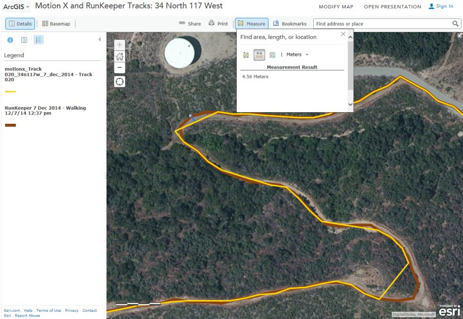
Comparing the spatial accuracy of two smartphone location apps in the field.
You must be a registered user to add a comment. If you've already registered, sign in. Otherwise, register and sign in.
About the Author
I believe that spatial thinking can transform education and society through the application of Geographic Information Systems for instruction, research, administration, and policy.
I hold 3 degrees in Geography, have served at NOAA, the US Census Bureau, and USGS as a cartographer and geographer, and teach a variety of F2F (Face to Face) (including T3G) and online courses. I have authored a variety of books and textbooks about the environment, STEM, GIS, and education. These include "Interpreting Our World", "Essentials of the Environment", "Tribal GIS", "The GIS Guide to Public Domain Data", "International Perspectives on Teaching and Learning with GIS In Secondary Education", "Spatial Mathematics" and others. I write for 2 blogs, 2 monthly podcasts, and a variety of journals, and have created over 6,500 videos on my Our Earth YouTube channel.
Yet, as time passes, the more I realize my own limitations and that this is a lifelong learning endeavor: Thus I actively seek mentors and collaborators.
Labels
-
Administration
90 -
Announcements
88 -
Career & Tech Ed
1 -
Curriculum-Learning Resources
286 -
Education Facilities
24 -
Events
77 -
GeoInquiries
1 -
Higher Education
618 -
Informal Education
286 -
Licensing Best Practices
102 -
National Geographic MapMaker
43 -
Pedagogy and Education Theory
241 -
Schools (K - 12)
282 -
Schools (K-12)
308 -
Spatial data
39 -
STEM
3 -
Students - Higher Education
259 -
Students - K-12 Schools
147 -
Success Stories
44 -
TeacherDesk
1 -
Tech Tips
129
- « Previous
- Next »