Turn on suggestions
Auto-suggest helps you quickly narrow down your search results by suggesting possible matches as you type.
Cancel
- Home
- :
- All Communities
- :
- Industries
- :
- Education
- :
- Education Blog
- :
- A Good Map Teaches You To Ask A Better Question
A Good Map Teaches You To Ask A Better Question
Subscribe
1055
0
12-14-2012 01:28 AM
- Subscribe to RSS Feed
- Mark as New
- Mark as Read
- Bookmark
- Subscribe
- Printer Friendly Page
12-14-2012
01:28 AM
During a workshop I attended at the Esri User Conference this past summer, my colleague Charlie Frye stated that “a good map teaches you to ask a better question.” I love this statement. It fits well with the mission of the GIS education community, don’t you think? Isn’t one of our main goals in teaching and learning with GIS to use maps and data to investigate our communities, our regions, our countries, and our world? A question is the first step in an investigation. It is the first step in the geographic inquiry process. Whether the question is “What is the relationship between birth rate and life expectancy around the globe?” or “How did the construction of the breakwater change the rate of coastal erosion along this stretch of beach?” or “Why were communities along the path of Superstorm Sandy affected differently?”, these questions form the foundation of our investigations. Good questions inevitably get refined and modified along the way and usually lead to other questions. They may not be fully answered, and oftentimes have no single correct answer. This may be puzzling at first to students but emulates real-world decision-making.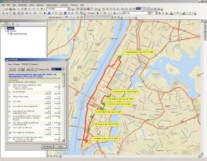
In this activity, students determine the optimal route for a tourist bus through Manhattan given specified points of interest and the location of the tour bus garage.
As important as good questions are, it is sometimes amazing how little time we spend in our educational system helping students practice asking good questions. Perhaps it is because in this age of standardized testing, we are so focused on good answers. Yet many educators are indeed helping students ask questions, and not just any questions, but thoughtful questions that can lead to increased understanding, skill building, and critical thinking.
Teaching with GIS and teaching about GIS foster good questioning. One of the core functions of a GIS is to allow for real-world issues to be examined, questioned, and probed with real data. Maps in a GIS environment allow for the many spatial and temporal dimensions of our world to be examined, at multiple scales. Not only are the questions able to be grappled with using rich sets of maps and data, but they are tied to real-world events past and present. They are interesting, but they are also important and relevant for our future, including such issues as sustainable agriculture, natural hazard management, smart city planning, and much more. Maps inside a GIS environment help students of all ages to ask better questions in part because during the inquiry, they allow for the scale and symbology to be changed, for additional layers to be added, and for powerful queries and statistics to be run on the data. The “what if” questions can be explored, such as: What if I changed the scale? What if I added this variable? What if I ran a different query? What if I examined a different area with the same variables? What if I classified the data differently? ArcGIS provides a platform for asking and analyzing questions.
What questions do you have about our world? How can GIS help you grapple with those questions, find answers, or ask additional questions?
- Joseph Kerski, Esri Education Manager
You must be a registered user to add a comment. If you've already registered, sign in. Otherwise, register and sign in.
About the Author
I believe that spatial thinking can transform education and society through the application of Geographic Information Systems for instruction, research, administration, and policy.
I hold 3 degrees in Geography, have served at NOAA, the US Census Bureau, and USGS as a cartographer and geographer, and teach a variety of F2F (Face to Face) (including T3G) and online courses. I have authored a variety of books and textbooks about the environment, STEM, GIS, and education. These include "Interpreting Our World", "Essentials of the Environment", "Tribal GIS", "The GIS Guide to Public Domain Data", "International Perspectives on Teaching and Learning with GIS In Secondary Education", "Spatial Mathematics" and others. I write for 2 blogs, 2 monthly podcasts, and a variety of journals, and have created over 6,500 videos on my Our Earth YouTube channel.
Yet, as time passes, the more I realize my own limitations and that this is a lifelong learning endeavor: Thus I actively seek mentors and collaborators.
Labels
-
Administration
86 -
Announcements
87 -
Career & Tech Ed
1 -
Curriculum-Learning Resources
278 -
Education Facilities
24 -
Events
77 -
GeoInquiries
1 -
Higher Education
612 -
Informal Education
284 -
Licensing Best Practices
99 -
National Geographic MapMaker
39 -
Pedagogy and Education Theory
238 -
Schools (K - 12)
282 -
Schools (K-12)
301 -
Spatial data
39 -
STEM
3 -
Students - Higher Education
255 -
Students - K-12 Schools
141 -
Success Stories
44 -
TeacherDesk
1 -
Tech Tips
129
- « Previous
- Next »