- Home
- :
- All Communities
- :
- Industries
- :
- Education
- :
- Education Blog
- :
- 10 New ArcGIS Pro Lesson Activities, Learn Paths, ...
10 New ArcGIS Pro Lesson Activities, Learn Paths, and Migration Reflections
- Subscribe to RSS Feed
- Mark as New
- Mark as Read
- Bookmark
- Subscribe
- Printer Friendly Page
A new set of 10 ArcGIS Pro lessons empowers GIS practitioners, instructors, and students with essential skills to find, acquire, format, and analyze public domain spatial data within a GIS environment to make decisions. Described in this video, this set was created for 3 reasons: (1) to provide a set of analytical lessons that can be immediately used, (2) to update the original 10 lessons created by my colleague Jill Clark and I to provide a practical component to our Esri Press book The GIS Guide to Public Domain Data, and (3) to demonstrate how ArcGIS Desktop (ArcMap) lessons can be converted to Pro and to reflect upon that process. This essay is mirrored on the Spatial Reserves data blog, and my migration reflections are below and also in this video.
Summary of Lessons:
- Can be used in full, in part, or modified to suit your own needs.
- 10 lessons.
- 64 work packages. A "work package" is a set of tasks focused on solving a specific problem.
- 370 guided steps.
- 29 to 42 hours of hands-on immersion.
- Over 600 pages of content.
- 100 skills are fostered, covering GIS tools and methods, working with data, and communication.
- 40 data sources are used covering 85 different data layers.
- Themes covered: climate, business, fire, floods, hurricanes, land use, sustainability, ecotourism, invasive species, oil spills, volcanoes, earthquakes, agriculture.
- Areas covered: The Globe, and also: Orange County California, Nebraska, Colorado, Texas, Brazil, New Zealand, the Great Lakes of the USA, Canada, the Gulf of Mexico, Iceland, the Caribbean Sea, and Kenya.
- Aimed at university-level graduate and university or community college undergraduate student. Some GIS experience is very helpful, though not absolutely required. Still, my advice is not to use these lessons for students' first exposure to GIS, but rather, in an intermediate or advanced setting.
Why use these lessons? The lessons offer 8 unique advantages: (1) The lessons engage students by focusing on the geographic inquiry process, beginning with the problem to be solved, such as the optimal site for siting a new business in a metropolitan area, the rate and pattern of the spread of an invasive species, the ideal locations for growing tea in Kenya, assessing reservoir and dam vulnerability in the event of a hurricane, and more. (2) While those working through the lessons build solid GIS skills (building expressions, joining data layers, intersecting, projecting, georegistering imagery), skills are not limited to "learning more GIS". Skills in data management and communication are a prominent part of these lessons. At the end of each lesson, students are asked to communicate the results of their research in a variety of ways, including sharing to ArcGIS Online, making a short video, and creating a web mapping application such as a story map. (3) A significant proportion of each lesson touch on accessing, formatting, projecting; i.e. developing data competencies. Helping people make wise decisions about the data, and giving them practical skills in doing so, is one of our chief goals with these lessons and the book. A balance is struck between engaging with enough data to provide a realistic scenario, but recognizing that "more is not always better." (4) The same lesson is available in an ArcGIS Desktop (ArcMap) format and an ArcGIS Pro format, so that those still hesitating about migrating from ArcGIS Desktop to ArcGIS Pro can use these as an example that it is not only possible, but there are many advantages to doing so. (5) Questions posed in each lesson focus on thoughtful reflection about the data and the process, such as, "what difference would data at a different scale have on your analysis results?", "what was the most significant thing you learned about natural hazards in this lesson?" and "if you had more time, what data set might you have also wanted to include in your analysis? Where do you think you could obtain such data?" (6) These lessons have been tested and refined over several terms with students across many universities. (7) An answer key is available for each lesson. But in keeping with the reflective nature of these lessons, often there is no "single correct answer." (8) A lesson on building an ecotourism map in New Zealand allows students to use their gained skills in an independent project where they decide what themes to choose, what data to use, how to process it, and what problems to solve.
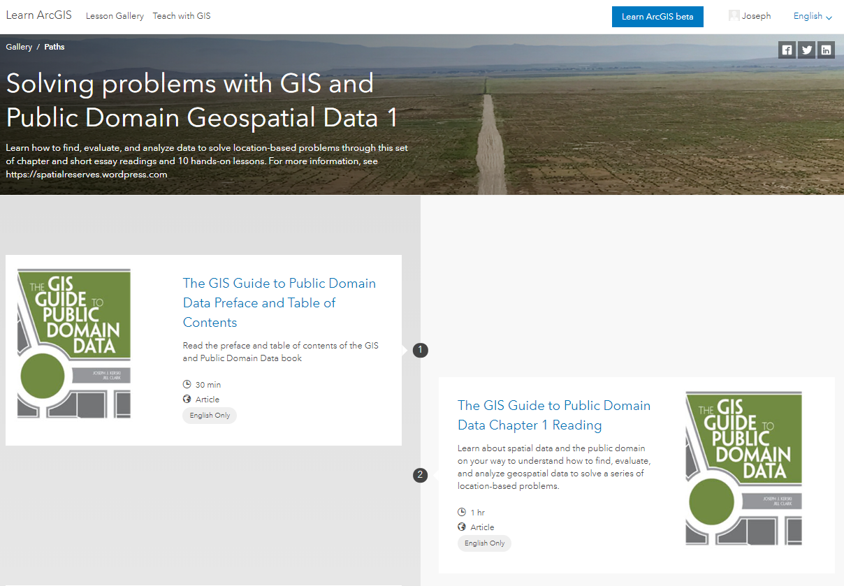
How to access the lessons: The ideal way to work through the lessons is in a Learn Path which bundle the readings of the book's chapters, selected blog essays, and the hands-on activities.. The Learn Paths are split into 3 parts, as follows:
Solving Problems with GIS and public domain geospatial data 1 of 3: Learn how to find, evaluate, and analyze data to solve location-based problems through this set of 10 chapters and short essay readings, and 10 hands-on lessons: https://learn.arcgis.com/en/paths/the-gis-guide-to-public-domain-data-learn-path/
Solving Problems with GIS and public domain geospatial data 2 of 3: https://learn.arcgis.com/en/paths/the-gis-guide-to-public-domain-data-learn-path-2/
Solving Problems with GIS and public domain geospatial data 3 of 3: https://learn.arcgis.com/en/paths/the-gis-guide-to-public-domain-data-learn-path-3/
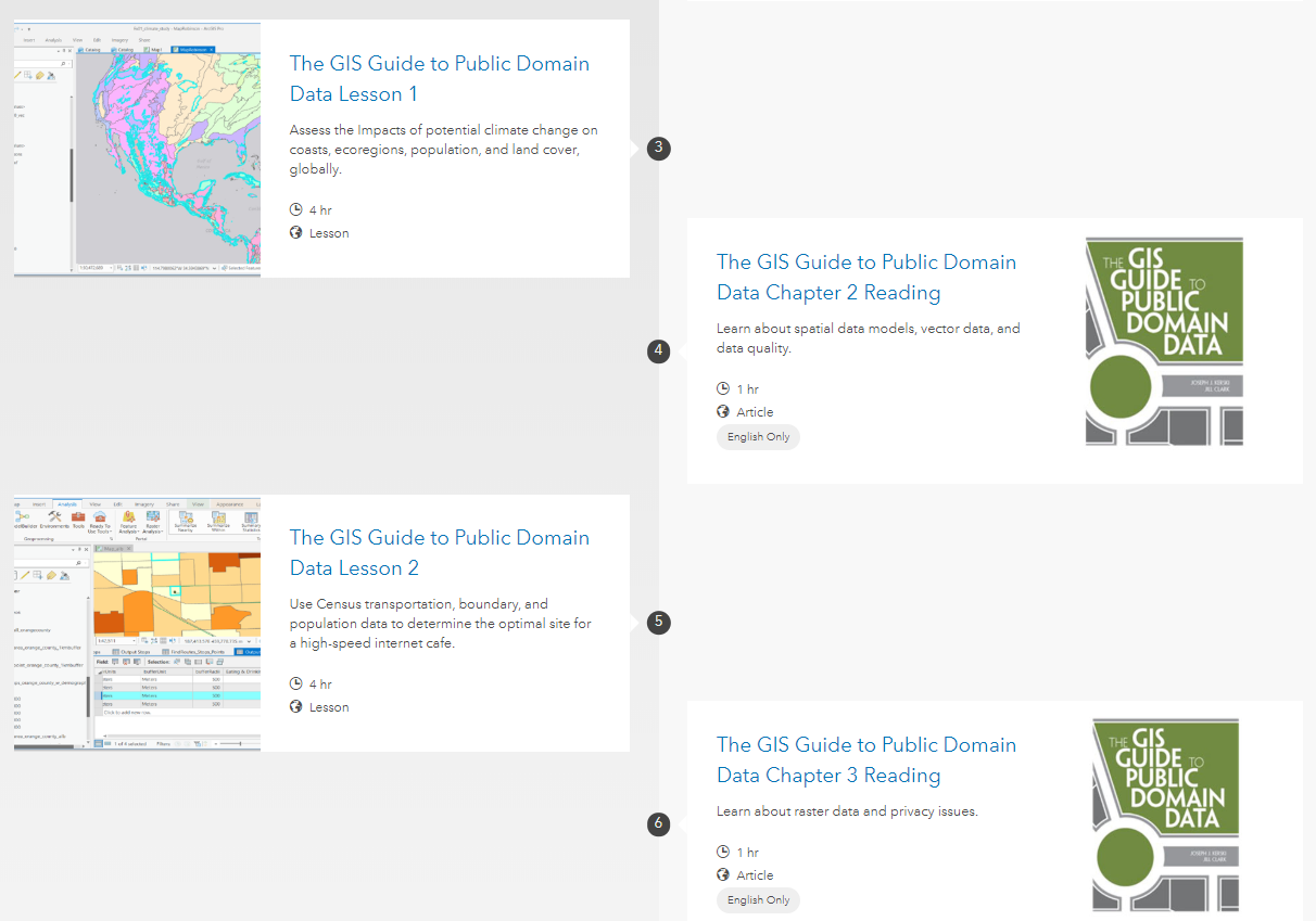
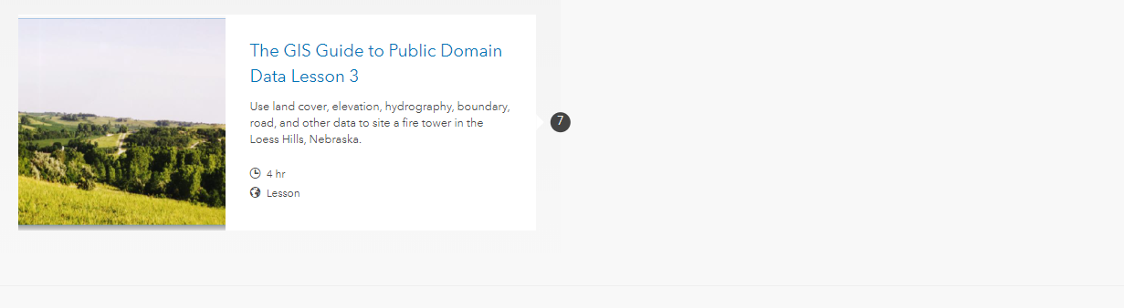
The Learn Paths allow for content to be worked through in sequence, as shown below:
Sample Learn Path for the public domain data activities.
You can also access the lessons by accessing this gallery in ArcGIS Online, shown below. If you would like to modify the lessons for your own use, feel free! This is why the lessons have been provided in a zipped bundle as PDF files here and as MS Word DOCX files here. This video provides an overview.
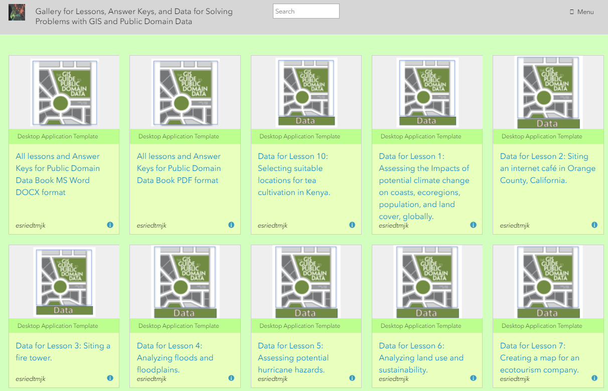
Appearance of content items in the public domain data activities and reading gallery. The gallery includes lessons, data, readings, and the answer keys.
While the intent is for learners to actually download or stream the data from the original sources as an important part of the learning experience, the data for each lesson in zip file format are also included, in this ArcGIS Online gallery. The reason the data is provided is because we recognize that sometimes, bandwidth is limited and/or the data portals are slow, change, or are temporarily offline.
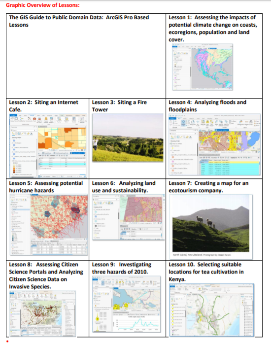
Titles of the 10 Lessons: See below. For more information, see the detailed metadata for the lessons here. 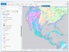 Lesson 1: Assessing impacts of climate change on coasts, ecoregions, and population globally.
 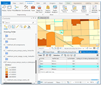 Lesson 2: Siting an internet café in Orange County, California.
  Lesson 3: Siting a fire tower in the Loess Hills, Nebraska.
  Lesson 4: Analyzing floods and floodplains along the Front Range, Colorado.
 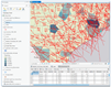 Lesson 5: Assessing potential hurricane hazards in Texas.
 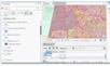 Lesson 6: Analyzing land use and sustainability in Brazil.
 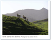 Lesson 7: Creating a map for an ecotourism company in New Zealand.
 Lesson 8: Assessing citizen science portals and analyzing data about invasive species.
 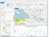 Lesson 9: Investigating 3 hazards: Gulf oil spill, Eyjafjallajokull volcano, and Haiti earthquake.
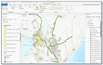 Lesson 10: Selecting the most suitable locations for tea cultivation in Kenya.
The intent of the lessons was that they were to be used in conjunction with reading the book. Therefore, the contents of the book have also been placed online. The book chapters are in this gallery. The book not only discusses sources and types of spatial data, but also issues such as assessing data quality, open data access, spatial law, the fee vs. free debate, data and national security, the efficacy of spatial data infrastructures, and the impact of cloud computing and the emergence of GIS as a Software-as-a-Service (SaaS) model.
Since the book was published, ongoing social and technological innovations and issues continue to change how data users and data providers work with geospatial information to help address a diverse range of social, economic and environmental needs. Therefore, we established the Spatial Reserves blog to promote a current, ongoing dialogue with data users and providers and post frequent assessments of new tools, data portals, books and articles, curriculum, and issues surrounding spatial data. Recent entries include "Imagery--It is what it is--well, not always.", "Be a wise consumer of fun posts, too", "The Application for Extracting and Exploring Analysis Ready Samples (AppEEARS)", reflections on a new article about the geospatial data fabric, facial recognition technology, and a list of the top 12 sites for Landsat data. A selection of these blog essays are listed in the book's resources page at Esri Press.
Reflections on Migrating Lessons from ArcMap to ArcGIS Pro. Readers of the GeoNet education blog are familiar with the rapid change of the field of geospatial technologies, coupled with rapidly changing educational and workplace needs. I contend that given these changes, the content and skills we must teach, and the means by which we ... Given the wide variety of tutorials and help files containing graphics and videos, networks and the tools to collaborate, ask questions, and share ideas, students, faculty, and GIS professionals have an amazing variety of learning options at their fingertips.
Thus, I do not believe we need to be focused on tool-based approaches, such as how to geocode, how to georegister, and so on, but rather, how to solve problems using GIS. (For a related discussion, see David DiBiase's Stop Teaching GIS essay). We need to help students "learn how to learn" whether in GIS (and, I contend, in any other field), emulating the kind of resource gathering, networking, and problem solving that they will assuredly use in the workplace. Some might argue that writing and asking students to go through lessons such as the 10 I describe above is no longer needed. In my experience in teaching for over 25 years at the university level, I still find that this style of lesson still has a place in learning, as students using these go through an entire workflow of geographic inquiry, including asking geographic questions, gathering data, analyzing data, making decisions, making assessments, and communicating the results of their research. Another reason why I created the above lessons is so that you can place each lesson side-by-side to compare the ArcMap version and the ArcGIS Pro version.
My observations after creating ArcGIS Pro versions of each of the ArcMap lessons are as follows:
- I have used these lessons in several different universities, including at the University of Denver, and always pose a survey question about ArcGIS Pro at the end of the course. In 95% of the responses, students have stated that they found ArcGIS Pro to be easier to learn from than ArcMap, more intuitive, and more powerful. Several students each term tell me that the use of Pro was one of their primary reasons for taking the course, because their employer asked them to learn it. And moving forward into the 2020s, Pro will see further adoption and more importantly, further evolution. Every time it evolves, it becomes more powerful and easier to use at the same time.
- As an instructor, you have a choice of either creating your own lessons or using existing lessons. There are no shortage of existing lessons, ranging from the ArcGIS Learn library to shared higher education resources (such as GeoTech Center and iGETT), Esri and university MOOCs, and many other resources. Many of us, however, became instructors because we enjoy creating and customizing curriculum for specific courses and programs. If you are keen on migrating some of your existing ArcMap lessons to ArcGIS Pro, I did it, and so can you. Yes, it will take some time, but I find migrations (migrations is plural here, as I have lived through many such software migrations!) are like when you get rid of things while moving your own residence--it is a good opportunity to purge old content and make things even better. Perhaps you can get a graduate student to assist you in this effort!
- I found that my ArcGIS Pro lessons were shorter than the ArcMap lessons for several reasons. The first reason is that the workflows in ArcGIS Pro are so much more logical and straightforward than in ArcMap. In ArcMap, for example, when you needed to georegister an unprojected historical map or aerial photo, you are cast into a zone that sometimes left students wondering, "what step do I do first?" whereas with ArcGIS Pro, you are placed into wizard-driven "Step 1--do this, make these choices, satisfied? If not, here are some adjustments you can make. OK - on to Step 2..." Ditto for hundreds of other tools and processes: These are much easier to follow and learn from using ArcGIS Pro. The second reason is you don't need to screen shot everything any longer, and in fact, I implore you to please not screen shot very much, because (1) There are many good existing resources for use if a student gets stuck on a certain section. In the past, I admit that all of us did have to create our own graphics and screenshots because these were by and large all the students could use as instructional resources, but no longer! (2) Students, being the resourceful people they are, will not read your precious screen shots very much if at all. They know there are other resources and will find them if they have difficulty. Of course you can provide guidance as to where these resources are, but just like anything else these days that people want to learn, such as fixing a faucet or playing the ukulele, there is a video, a graphic, a tutorial, on everything from geocoding to writing Arcade expressions and more. (3) If you do screen shot to excess and make your lessons consequently long, you will remain in a continuous cycle of having to update and curate your lessons. Please, don't do this! Rather, spend less time updating curriculum, and that new-found time creating new curricular ideas, teaching techniques, and furthering your own research.
Metadata for Public Domain Data lessons. I look forward to your comments below.
You must be a registered user to add a comment. If you've already registered, sign in. Otherwise, register and sign in.
-
Administration
90 -
Announcements
87 -
Career & Tech Ed
1 -
Curriculum-Learning Resources
285 -
Education Facilities
24 -
Events
77 -
GeoInquiries
1 -
Higher Education
618 -
Informal Education
286 -
Licensing Best Practices
102 -
National Geographic MapMaker
42 -
Pedagogy and Education Theory
241 -
Schools (K - 12)
282 -
Schools (K-12)
307 -
Spatial data
39 -
STEM
3 -
Students - Higher Education
259 -
Students - K-12 Schools
146 -
Success Stories
44 -
TeacherDesk
1 -
Tech Tips
128
- « Previous
- Next »