- Home
- :
- All Communities
- :
- Developers
- :
- Developers - General
- :
- Developers Questions
- :
- Model Builder Tool Changes Input Layers
- Subscribe to RSS Feed
- Mark Topic as New
- Mark Topic as Read
- Float this Topic for Current User
- Bookmark
- Subscribe
- Mute
- Printer Friendly Page
Model Builder Tool Changes Input Layers
- Mark as New
- Bookmark
- Subscribe
- Mute
- Subscribe to RSS Feed
- Permalink
I keep having an intermittent issue with several different models. When I run them from the toolbox, one or more of the original input layers will randomly change to a different layer. This mostly happens when I reopen my project the next day, but not always. Sometimes the underlying layer within the model properties changes, sometimes is does not, but the labels always stay correct.
I found that when I open the tool from the toolbox and before running it in the geoprocessing pane, if I switch to a Layout and then back to the Map view, the tool refreshes and often changes back to the correct layer.
The input layers are hosted feature services and I have them set as parameters. I'm using Pro 2.8.3.
Am I doing something wrong, or is this a bug, or just a refresh issue? PLEASE HELP
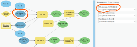
See the picture below. The top two parameters are my input layers. You can see that the first one changed to a different layer in the dropdown. But the correct layer is shown in the model, and when I open the tool properties everything is correct this time (sometimes it changes though).
- Mark as New
- Bookmark
- Subscribe
- Mute
- Subscribe to RSS Feed
- Permalink
Hi @BhargavCSA, we appreciate you sharing a potential bug with the broader Esri Community; however, Esri does not actively track software defects posted here. The official channel for investigating and validating bugs is Esri Technical Support. All customers experiencing a potential software bug should leverage technical support to report and investigate the issue.
By reporting bugs through technical support, Esri can better track the scope and impact of the issue across all our customers and better prioritize it with our product teams. Our teams can also investigate the issue more thoroughly to see if there is a solution, workaround, or patch to get you back up and running as soon as possible.
As a reminder, Esri Community is primarily a self-service support platform where Esri users can ask or answer each other’s questions, share feature requests, and collaborate to solve problems with GIS.
*Note that this is a scripted message prompted when posts allude to a potential product bug.
Community Manager, Engagement & Content
- « Previous
- Next »
- « Previous
- Next »
