- Home
- :
- All Communities
- :
- Developers
- :
- Developers - General
- :
- Developers Questions
- :
- Re: Model Builder Tool Changes Input Layers
- Subscribe to RSS Feed
- Mark Topic as New
- Mark Topic as Read
- Float this Topic for Current User
- Bookmark
- Subscribe
- Mute
- Printer Friendly Page
Model Builder Tool Changes Input Layers
- Mark as New
- Bookmark
- Subscribe
- Mute
- Subscribe to RSS Feed
- Permalink
I keep having an intermittent issue with several different models. When I run them from the toolbox, one or more of the original input layers will randomly change to a different layer. This mostly happens when I reopen my project the next day, but not always. Sometimes the underlying layer within the model properties changes, sometimes is does not, but the labels always stay correct.
I found that when I open the tool from the toolbox and before running it in the geoprocessing pane, if I switch to a Layout and then back to the Map view, the tool refreshes and often changes back to the correct layer.
The input layers are hosted feature services and I have them set as parameters. I'm using Pro 2.8.3.
Am I doing something wrong, or is this a bug, or just a refresh issue? PLEASE HELP
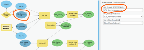
See the picture below. The top two parameters are my input layers. You can see that the first one changed to a different layer in the dropdown. But the correct layer is shown in the model, and when I open the tool properties everything is correct this time (sometimes it changes though).
- Mark as New
- Bookmark
- Subscribe
- Mute
- Subscribe to RSS Feed
- Permalink
Sorry, don't have an answer for you, I just want to echo, that the same frustrating thing is happening to me:(
- Mark as New
- Bookmark
- Subscribe
- Mute
- Subscribe to RSS Feed
- Permalink
Thanks! At least I'm not the only one. I was finding that even though the layer changed in the parameters, when I export the model to python, the layers were correct. Seems like there's a little glitch in there on the model builder side of things. In most cases, my parameters didn't need to change anyway, so I just ended up removing the parameters to run the tools.
- Mark as New
- Bookmark
- Subscribe
- Mute
- Subscribe to RSS Feed
- Permalink
I am testing out a theory, I was initially using shapefiles for some of my inputs, and I have now converted those inputs into a feature class. I haven't completely tested this, and so far it is promising. I saw something in a blog that prompted me to try it.
- Mark as New
- Bookmark
- Subscribe
- Mute
- Subscribe to RSS Feed
- Permalink
I was using feature services. Let me know what you find out. It seemed like most of the time the problem would happen after I added or removed layers from my contents.
- Mark as New
- Bookmark
- Subscribe
- Mute
- Subscribe to RSS Feed
- Permalink
Did you ever figure out what was causing the inputs to shift? I'm experiencing the same issue.
- Mark as New
- Bookmark
- Subscribe
- Mute
- Subscribe to RSS Feed
- Permalink
Nope. Most of the time it seems adding/removing layers to the map is the culprit, but not always. In model builder, when you hover over the tool it appears to show the correct layers, but when you open the tool it doesn't show the correct layers. I always run my models through the toolbox. If the layers are set as parameters in the tool, I just change it to the correct layers and the models runs correctly as it's supposed to. Or just remove the parameters and the model appears to run correctly as well. Hope this helps.
- Mark as New
- Bookmark
- Subscribe
- Mute
- Subscribe to RSS Feed
- Permalink
Thanks for the response! That workaround sounds pretty similar to what I've been doing as well. I also thought it had something to do with add/removing layers, but that turned out not to be the case.
- Mark as New
- Bookmark
- Subscribe
- Mute
- Subscribe to RSS Feed
- Permalink
I'm having the same issue. For me it doesn't matter wether the inputs are shapefiles or feature classes, and it doesn't matter wether I drag and drop them from the map, select them from the drop down-list or if navigate to their location on the server. Very frustrating!
