- Home
- :
- All Communities
- :
- Products
- :
- ArcGIS QuickCapture
- :
- ArcGIS QuickCapture Questions
- :
- Can I collect multiple attributes on the same line...
- Subscribe to RSS Feed
- Mark Topic as New
- Mark Topic as Read
- Float this Topic for Current User
- Bookmark
- Subscribe
- Mute
- Printer Friendly Page
Can I collect multiple attributes on the same line?
- Mark as New
- Bookmark
- Subscribe
- Mute
- Subscribe to RSS Feed
- Permalink
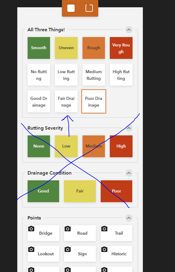
I am working on a method for collecting information about a rail trail. I have identified 3 or 4 trail attributes to be collected via a line feature: roughness, rutting, drainage, surface material (pictured in the attached screen grab). I've got it working but it looks like this give you a separate line feature for each attribute.
Is this expected?
If yes, how are folks putting things back together? Integrate and Union? In my test, the lines weren't coincident.
If no, what changes do I need to make to my feature layer/QuickCapture template?
Solved! Go to Solution.
Accepted Solutions
- Mark as New
- Bookmark
- Subscribe
- Mute
- Subscribe to RSS Feed
- Permalink
If you want to have a single line capture this information, you will need to create buttons that combine all attributes.
For example:
Button 1:
Roughness: Smooth
Rutting Severity: None
Drainage Condition: Good
Button 2:
Roughness: Uneven
Rutting Severity: None
Drainage Condition: Good
Button 3:
Roughness: Rough
Rutting Severity: None
Drainage Condition: Good
Button 4:
Roughness: Very rough
Rutting Severity: None
Drainage Condition: Good
etc....
But as you can see, you would need many button combinations to do this.
One way to reduce the number of separate buttons is to use a button user input for one of the attributes. For example, you could create separate buttons combining Rutting Severity and Drainage Condition (4 *3 = 12 buttons). Then, when the user ends the line they could enter the Roughness manually. The app supports coded value domains, so the user would just pick from the list of options (Smooth, uneven, Rough and Very Rough) and then submit.
Thanks
John
- Mark as New
- Bookmark
- Subscribe
- Mute
- Subscribe to RSS Feed
- Permalink
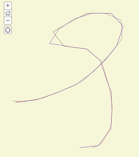
Here is what the three lines look like from a quick walk in the parking lot. Each of the three condition attributes makes its own line (with null values for the other two attributes). It's a bit hard to see but sometimes the lines are on top of each other and other times they aren't.

- Mark as New
- Bookmark
- Subscribe
- Mute
- Subscribe to RSS Feed
- Permalink
Hi,
Thanks for reaching out to us. From the descriptions above, I believe there are spaces to improve the design of your current QuickCapture project. Feel free to drop an email at quickcapture@esri.com so that we can set up a video call to go through this in detail and better understand your workflow?
Thanks,
Mandy
- Mark as New
- Bookmark
- Subscribe
- Mute
- Subscribe to RSS Feed
- Permalink
Hi Henry
Yes, you can calculate multiple attributes on the same line. A button can be configured to update any or all of the non-sysstem fields in a layer.
When you create a project the designer looks at the layer symbology and creates a group from each layer, and button for each symbol. You can then override this to meet your needs. You can't have one button pointing to more than one layer. But you can remove buttons if you don't need them. You can also update the labels and styles of buttons, as well as the fields that are updated (and the values written to them) when the button is pressed.
In your case, because you have different layers in your feature service: Roughness, Rutting Severity, and Drainage Condition. You will need to capture different lines at the same time. The only other option would be to create a new layer that has combines all the fields in the 3 layers. This would allow you to capture a single line.
In terms of having all lines overlapping. As lines start at slightly different times, it takes a few vertices before the lines start to share the same geometry (this is a result of the way the database batches updates). After a while, you should find that the lines will be exactly the same. Please let us know if you are seeing anything different.
Thanks
John
- Mark as New
- Bookmark
- Subscribe
- Mute
- Subscribe to RSS Feed
- Permalink
Hi John,
Thanks for your response. I wasn't quite clear in my initial post. The roughness, rutting, and drainage items are in a single line feature (not different layers). Based on your feedback, I modified the buttons to look like the image below.

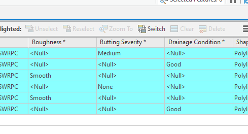
I'm still getting multiple, overlapping lines. Here's what the attribute table looks like.

Ideally, I would like to have one line segment for a trail and no null values. Here's the URL in case it helps: https://services2.arcgis.com/Lh31gHjN8TojXgnP/arcgis/rest/services/Cheshire_Rail_Trail_QuickCapture_....
Best,
Henry
- Mark as New
- Bookmark
- Subscribe
- Mute
- Subscribe to RSS Feed
- Permalink
If you want to have a single line capture this information, you will need to create buttons that combine all attributes.
For example:
Button 1:
Roughness: Smooth
Rutting Severity: None
Drainage Condition: Good
Button 2:
Roughness: Uneven
Rutting Severity: None
Drainage Condition: Good
Button 3:
Roughness: Rough
Rutting Severity: None
Drainage Condition: Good
Button 4:
Roughness: Very rough
Rutting Severity: None
Drainage Condition: Good
etc....
But as you can see, you would need many button combinations to do this.
One way to reduce the number of separate buttons is to use a button user input for one of the attributes. For example, you could create separate buttons combining Rutting Severity and Drainage Condition (4 *3 = 12 buttons). Then, when the user ends the line they could enter the Roughness manually. The app supports coded value domains, so the user would just pick from the list of options (Smooth, uneven, Rough and Very Rough) and then submit.
Thanks
John
- Mark as New
- Bookmark
- Subscribe
- Mute
- Subscribe to RSS Feed
- Permalink
This if very helpful - I feel like I have wrapped my head around this now.
Still open to suggestions about geoprocessing steps to merge separate lines with separate attributes together. This would make it possible for me to create an index or score based on multiple attributes at a certain section.
- Mark as New
- Bookmark
- Subscribe
- Mute
- Subscribe to RSS Feed
- Permalink
@JohnathanHasthorpe I am encountering the same issue as @HenryUnderwood1 . I have a point layer for which I need to collect multiple attributes quickly while in moving vehicle. These attributes include Crop Type (required, over 100 options), Irrigation Method (about 5 options), Age (3 options), Other (10 options), and Notes (text field). There is always a value entered for Crop Type, but the other attributes are there to record information if applicable, although not required for every data entry. Currently it looks like I can use Crop Type for my buttons, but it looks like I can only define one additional attribute to collect via a button user input. If so, the current set up for the QuickCapture App does not work for my workflow since I need to collect about 5 attributes per point collected (1 required, the others optional). I have previously used the ArcClassic app because it allowed for this information to be captured relatively quickly, and have since tried to transition to FieldMaps. However, I am finding that FieldMaps operates too slowly compared to ArcClassic. Quick Capture sounds like it was developed for the high speed work I am doing, but does not have the ability to capture all of the attributes I need. Any suggestions would be greatly appreciated.