- Home
- :
- All Communities
- :
- Products
- :
- ArcGIS Pro
- :
- ArcGIS Pro Questions
- :
- Input feature class is not registered as versioned...
- Subscribe to RSS Feed
- Mark Topic as New
- Mark Topic as Read
- Float this Topic for Current User
- Bookmark
- Subscribe
- Mute
- Printer Friendly Page
Input feature class is not registered as versioned???
- Mark as New
- Bookmark
- Subscribe
- Mute
- Subscribe to RSS Feed
- Permalink
So calculating geometry (area) on a 10.8.0.25 SQL 2014 Enterprise Feature Class, Geography Storage Type, GCS projection in 2.5, not registered as versioned, no branch versioning, archiving enabled returns
ERROR 130051: Input feature class is not registered as versioned.
Failed to execute (CalculateGeometryAttributes)
Drew Flater I recall this coming up in the past, can't find the GN post though, or maybe it was in EAP. Is there now a requirement that feature classes have to be registered as versioned to calculate geometry?
SQL trace shows
Violation of UNIQUE KEY constraint 'states_cuk'. Cannot insert duplicate key in object 'dbo.SDE_states'. The duplicate key value is (0, 0). as this is happening.
- Mark as New
- Bookmark
- Subscribe
- Mute
- Subscribe to RSS Feed
- Permalink
Hi Thomas Colson, I'm a little puzzled at this case, as our in-house test suite has cases just as you described that are passing and I just tried it myself in the application and the calc worked as expected.
If you look under the hood of Calculate Geometry Attributes, it uses arcpy.da.UpdateCursor to perform the updates. Some data sources and enterprise gdb configurations require an updatecursor in an edit session, some don't support edit sessions, it's really a grab bag. So the tool attempts to start and use an edit session when required or check that the cursor can retrieve data without the edit session. If it's not able to, it raises the error you described.
Attached is a screenshot of the test I ran using a SQL Server Enterprise GDB polygon feature class that has the Geography Configuration Keyword, GCS coordinate system, not registered as versioned, with archiving enabled. The Double field gets updated with the Area in sq miles as specified on the tool.
I can only say this is a case to report and work withing tech support, please.
All the best,
Drew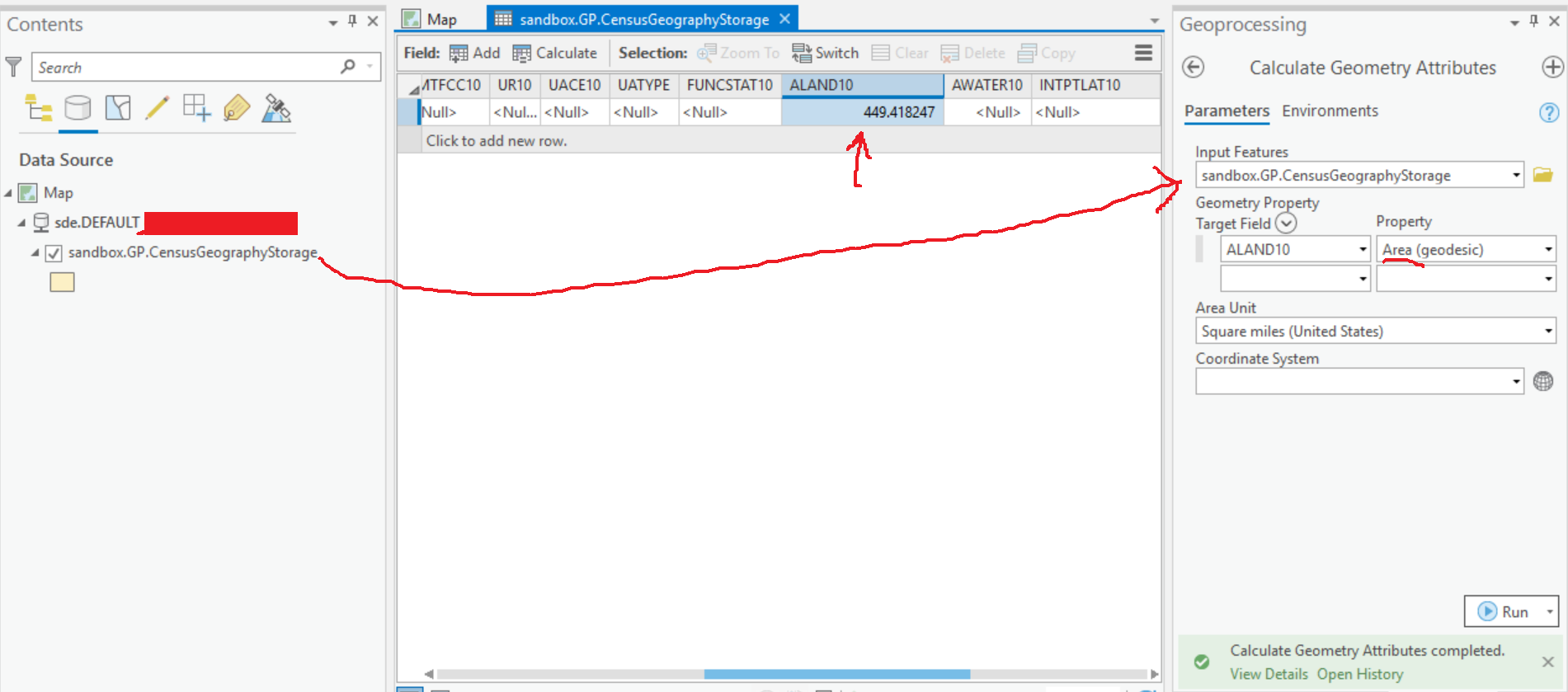
- Mark as New
- Bookmark
- Subscribe
- Mute
- Subscribe to RSS Feed
- Permalink
This may be a database issue I've since discovered. One feature (out of hundreds) has non-simple geometry, and SQL trace is showing other issues with the SDE core tables. This is an operational database that can't wait for TS to figure out what's wrong, our solution is going to be stand up a new SQL DB. With that said, I can open a case for the sole purpose of giving you a backup of the SQL DB, there is something going on with SDE that is causing GP tools to fail.
- Mark as New
- Bookmark
- Subscribe
- Mute
- Subscribe to RSS Feed
- Permalink
I too cannot calculate geometry, receiving the same error message - not registered as versioned:

Yet the data set is versioned:

I have gone through many of the posts regarding this problem, but haven't yet found an answer. Maybe the answer is in there, but being this was a brand new thread, I thought I might have more luck here.
I just updated Pro to 2.5.0.
Any direction is appreciated,
K
- Mark as New
- Bookmark
- Subscribe
- Mute
- Subscribe to RSS Feed
- Permalink
Can you give the exact details of your environment? Where is the data, what type/version of database, is it geometry or geography storage, what is the projection?
- Mark as New
- Bookmark
- Subscribe
- Mute
- Subscribe to RSS Feed
- Permalink
There may be more information here than you need, but I thought more might be better than not enough. I hope I got everything.
SQL Server Enterprise Geodatabase
Enterprise Gdb Feature Dataset
Replica Geodatabase
Microsoft Analysis Services Client Tools 11.0.7001.0
Microsoft Data Access Components (MDAC) 6.3.9600.16384
Microsoft MSXML 3.0 6.0
Microsoft Internet Explorer 9.11.9600.17207
Microsoft .NET Framework 4.0.30319.34014
Operating System 6.3.9600
Storage High Precision - Geometry
Projected CS: NAD 1983 StatePlane Virginia North FIPS 4501 (US Feet)
Lambert Conformal Conic
K
- Mark as New
- Bookmark
- Subscribe
- Mute
- Subscribe to RSS Feed
- Permalink
Can you run a SQL trace when your running the calc tool? In the trace, do you see errors with SDE_ITEMS and maybe a reference to a corrupt SDE log file? That's what I'm seeing. I would take this to TS, but I already have a bunch of cases open that I need to pay attention to.
- Mark as New
- Bookmark
- Subscribe
- Mute
- Subscribe to RSS Feed
- Permalink
No worries
- Mark as New
- Bookmark
- Subscribe
- Mute
- Subscribe to RSS Feed
- Permalink
I'm having to wait for the GIS Admin / IT for this. They have the request to run a trace, etc. But nobody can help right now.
- Mark as New
- Bookmark
- Subscribe
- Mute
- Subscribe to RSS Feed
- Permalink
Kathy is that SQL Server 2012 your hitting with Pro 2.5?