- Home
- :
- All Communities
- :
- Services
- :
- Implementing ArcGIS
- :
- Implementing ArcGIS Blog
- :
- Developing a Real-Time GIS Strategy
Developing a Real-Time GIS Strategy
- Subscribe to RSS Feed
- Mark as New
- Mark as Read
- Bookmark
- Subscribe
- Printer Friendly Page
Maps are no longer static. Off the shelf technology exists to visualize, analyse, and store the wealth of real-time information that is impacting your organization. Those that embrace real-time GIS can quicken their decision making and responsiveness.
The first question I posed to users at Esri's 2018 User Conference during a session with the same title was simply: Do you have a strategy? For the majority of attendees, the answer was a resounding 'no'.
To begin crafting a real-time GIS strategy, it makes sense to break down the concept into 3 discrete buckets: ingesting, transforming, and disseminating.
Ingesting
The most basic concept is simply, what data exists? How often is the data updated? How many sensors are there? Users should start to develop a catalog of the real-time data that exists throughout their organization as well as the attributes and frequency of updates. Most importantly, you should be aware of the wealth of real-time information that is provided through Esri's partners (found in the ArcGIS Marketplace) and the Living Atlas. Some of the these feeds include lightning strikes, storm tracks, stream gauges, drought monitors, and social media feeds. Please take a minute to peruse the content that is available here: Living Atlas Layers.
There is a wealth of real-time information available today that allows users to consume data that impacts their organization, without the need to generate that content. Users should build out a catalog of the data that is available through 3rd parties and also have a clear understanding of their own real-time sensor networks.
Transforming
While data coming from a sensor network can provide value straight from the feed, it typically needs to be transformed. Secondly, beyond a basic visualization, it is difficult to get a true understanding of overlapping or simultaneous events while viewing multiple real-time feeds. Transformations allow users to take their real-time information and use either the geometry or attributes of the features to trigger alerts, change symbology, or create additional features.
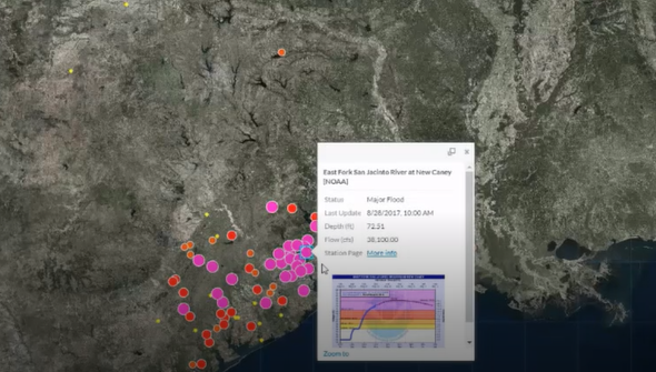
During Hurricane Rita, it was difficult, if not impossible to assess where facilities and populations were going to be impacted by the resulting floods. Yet, by combining facilities and the Living Atlas stream gauge layer, alerts could be generated using GeoEvent Server to show exactly where these impacts were going to occur. Rather than focus on all facilities or population centers, First Responders could focus on the populations with the highest risk and also filter the data to see where the flood stage would be the most critical, at what times.
Depending on the sensor network, readings could be generated at rates upwards of 60 times a second. This volume of data becomes unmanageable and impossible to analyze unless tranformations are applied. Please refer to this GeoEvent Server documentation to get a basic introduction to the types of processors that are available to better analyze your data. It is paramount that users understand the processes and tools that are available for them to transform their data into actionable information.
Disseminating
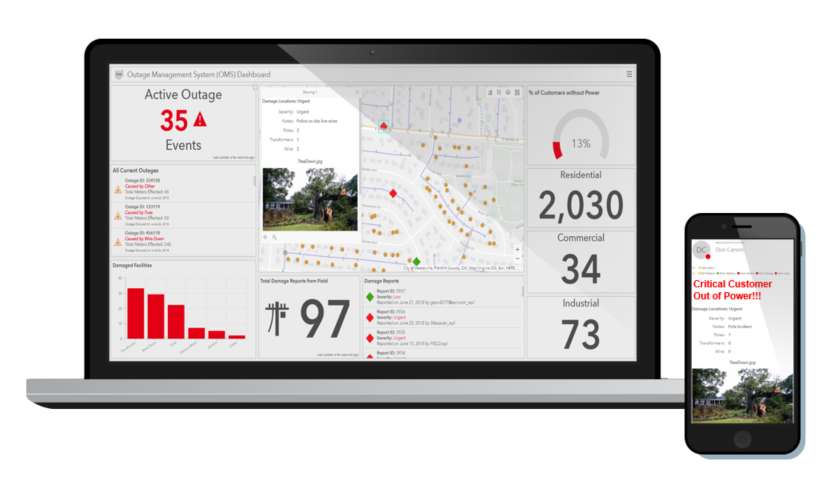
Lastly and mostly importantly, is turning your real-time data into actionable information. This could take the form of an SMS message, an e-mail, a dashboard, or a web application. Users should prioritize which information products will provide the most value to their organization and then work on a configurable delivery approach. There are a wide array of configurable tools available through Esri that provide the ability to display real-time information. Users simply need to be aware of the tools that are available and understand how those tools could best serve the end users that will be utilizing them.
Develop a Strategy!
If users understand the 3 key components of real-time GIS: ingesting, transforming, and disseminating, they can begin to develop the right strategy for their organization. Maps are no longer static. The maps and dashboards that users interact with on a daily basis should mirror the way your organization is operating in the real world.
Download the PPT for this presentation from the 2018 Esri User's Conference: Developing a Real-Time GIS Strategy
Architecting the ArcGIS Platform: Best Practices
This blog post, serves as a high-level introduction to one topic that is featured in the Architecting the ArcGIS Platform: Best Practices whitepaper published by Esri. Other topics include High Availability, Load Balancing, Security, and more. Please click on the link above to learn more or post comments to ask questions and engage with Esri staff.

You must be a registered user to add a comment. If you've already registered, sign in. Otherwise, register and sign in.