- Home
- :
- All Communities
- :
- Products
- :
- ArcMap (Retired)
- :
- ArcMap Questions
- :
- custom polyconic projection
- Subscribe to RSS Feed
- Mark Topic as New
- Mark Topic as Read
- Float this Topic for Current User
- Bookmark
- Subscribe
- Mute
- Printer Friendly Page
custom polyconic projection
- Mark as New
- Bookmark
- Subscribe
- Mute
- Subscribe to RSS Feed
- Permalink
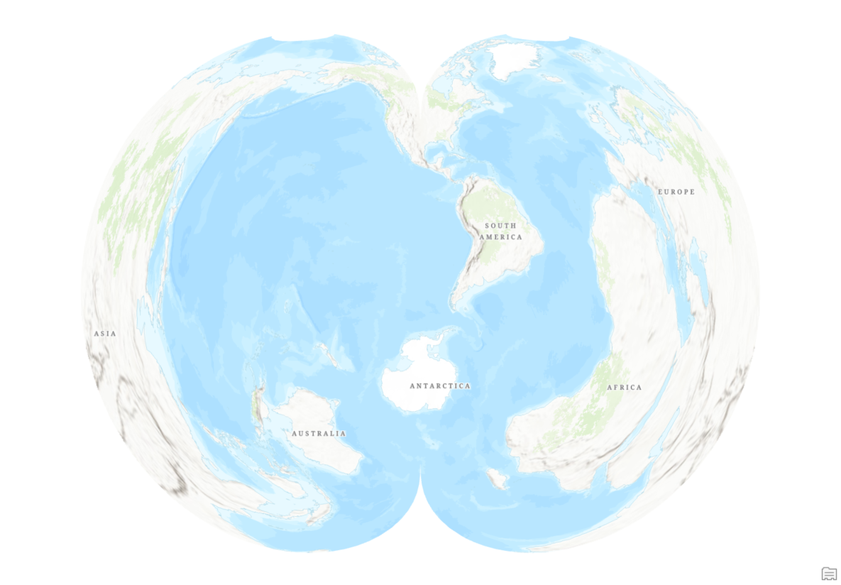
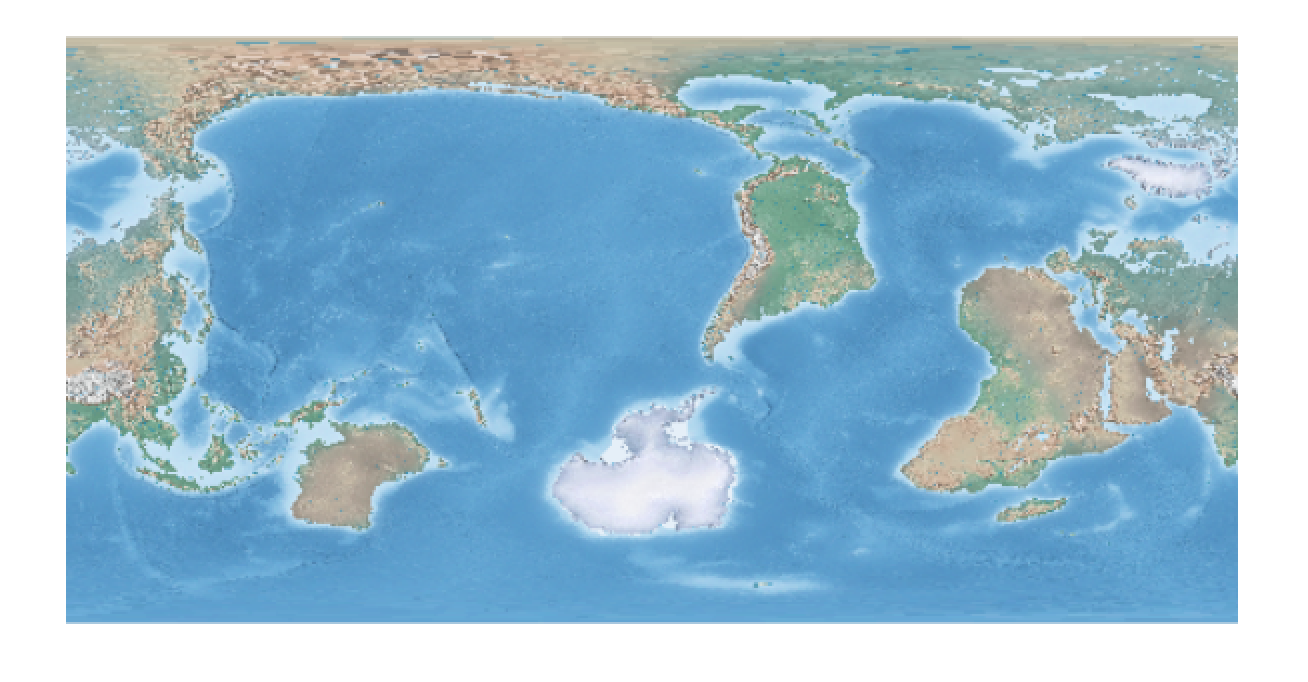
I'm helping an artist with a project that requires a modified polyconic projection of the world, centered on N America.
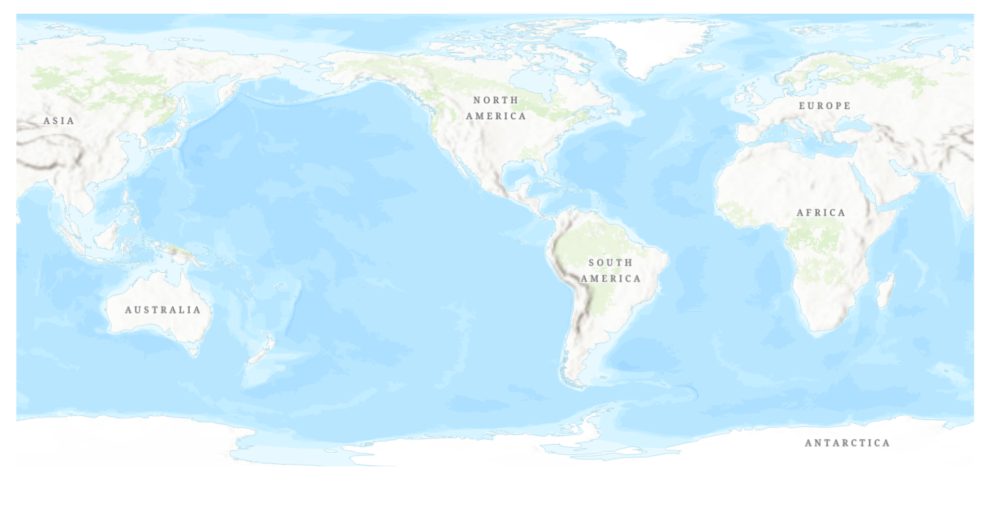
The artist wants to render globe gores, like the image attached below, but with the center on the US (around 100w 40n). In both ArcMap and ArcGIS Pro I am able to modify the Central Meridian of standard polyconic coordinate system to re center along 100w meridian, but I can't make any changes to the Latitude of Origin to put N America under the center of the north pole. FYI, the artist has another team member who is using Global Mapper to generate the centered globe gores, but is also unable to modify the coordinate system to recenter the map.
Any advice on how to change either the coordinate system itself or the input raster (Natural Earth GeoTIF) to get the desired effect is greatly appreciated.
- Mark as New
- Bookmark
- Subscribe
- Mute
- Subscribe to RSS Feed
- Permalink
Hi David!
Unfortunately, the polyconic projection is not implemented as an oblique map projection in ArcMap and ArcGIS Pro. The Latitude of Origin parameter only moves (0, 0) point to the given latitude on the Central Meridian.
- Mark as New
- Bookmark
- Subscribe
- Mute
- Subscribe to RSS Feed
- Permalink
Thanks Bojan. Sorry for taking so long to respond, been driving back home from Oregon. Given the parameters from my question above, to have the polyconic map centered on the US (around 100w 40n), can you think of a way to modify the input raster instead to accomplish that?
- Mark as New
- Bookmark
- Subscribe
- Mute
- Subscribe to RSS Feed
- Permalink
You could use custom geographic coordinate systems (GCS-es) and set of custom transformations (GT-s) to rotate your raster. See the workflow below.
NOTE: Described workflow is not recommended for high accuracy data and ellipsoids, and it does not work well with vector data.

Suggested workflow
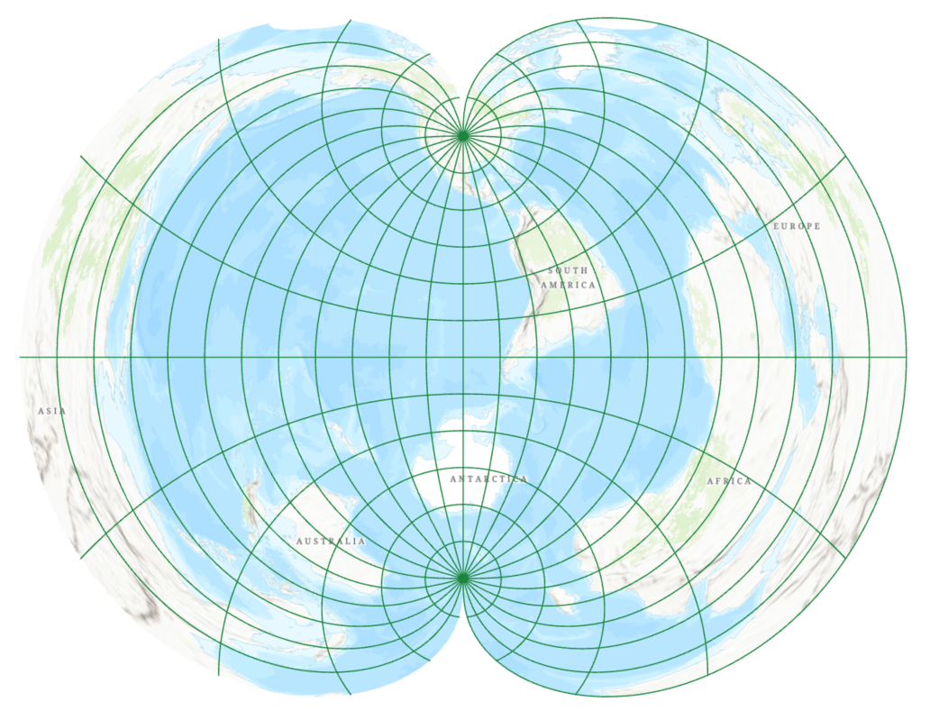
To generate a map the globe gores centered on 100° W 40° N, you need to rotate your center point to the North Pole. One way to accomplish that would be using two custom GCS-es and two custom GT-s:
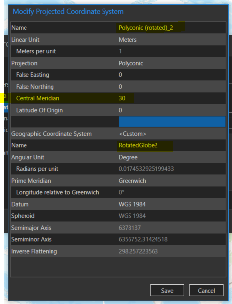
1) Open coordinate system picker, create and store in Favorites two custom GCS-es: e.g. RotatedGlobe1 and RotatedGlobe2.

2) Create a custom geographic transformation from GCS of your data, e.g. WGS 1984, to RotatedGlobe1 GCS. In my example, I used Coordinate Frame method, which includes rotation parameters, passed in seconds: -100° = -360 000". You could also use Longitude Rotation method in this step.
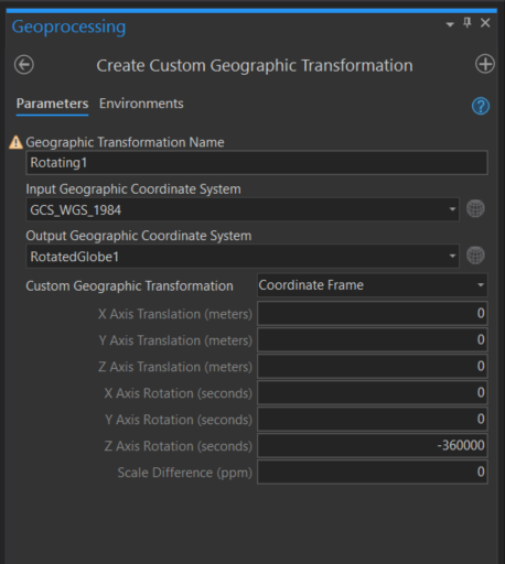
This rotates your raster around Earth's rotation axis, or Z-axis and shifts everything to 100° W meridian.
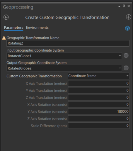
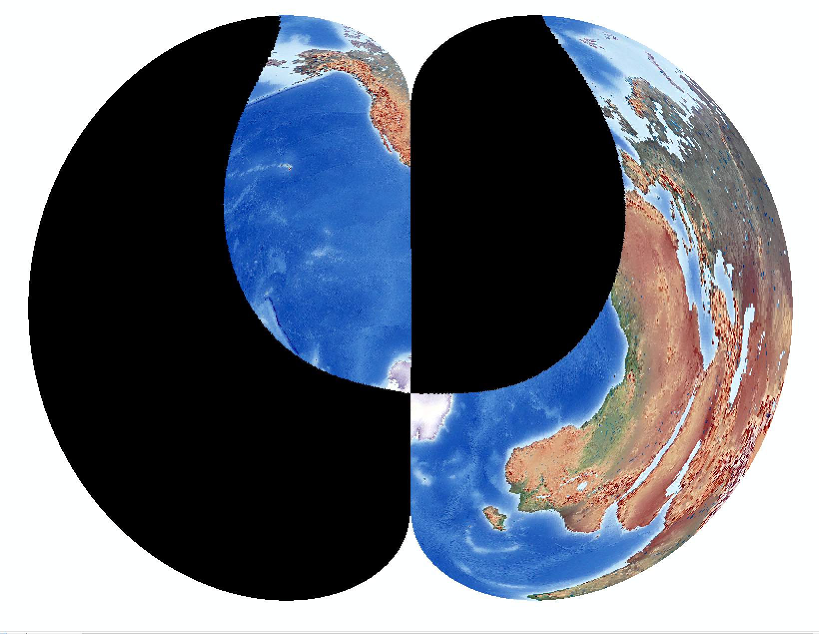
3) Create another custom geographic transformation from RotatedGlobe1 GCS to RotatedGlobe2 GCS. This time you rotate around Y-axis for 50° = 180 000". This moves your point, 100° W 40° N, to the "North Pole" location.
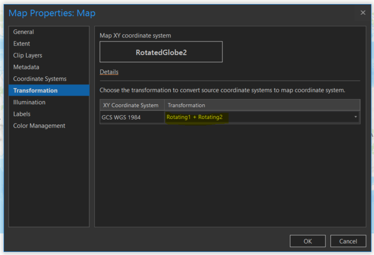
4) You go back to map properties and select map's coordinate system to be RotatedGlobe2 GCS and select two custom transformations to rotate your data properly.
Here is the resulting rotated raster:

5) You can also create a custom polyconic projected coordinate system and automatically project your data.
Note: In ArcGIS Pro 2.5, there are some issues with reading custom coordinate systems from Favorites, so you might have to manually input correct GCS definition when creating it. If done correctly, it will pick your custom transformations.

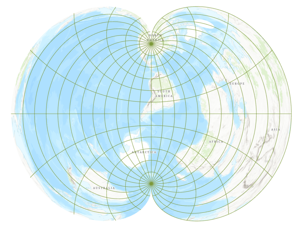
Here is the result.
6) You might want to overlay with un-transformed graticule to properly clip a gore. Create a copy of 15° graticule vector layer, use Define Projection tool to change GCS of that layer to be RotatedGlobe2 GCS, and add it to your map.
7) To generate other gores, just change Central Meridian parameter to shift everything to the center of the next gore.
Again, you might have to manually input correct GCS definition when creating it due to a bug in ArcGIS Pro 2.5.
- Mark as New
- Bookmark
- Subscribe
- Mute
- Subscribe to RSS Feed
- Permalink
Thank you again Bojan! This is great, I'll take a stab at this later this week. Cheers, David.
- Mark as New
- Bookmark
- Subscribe
- Mute
- Subscribe to RSS Feed
- Permalink
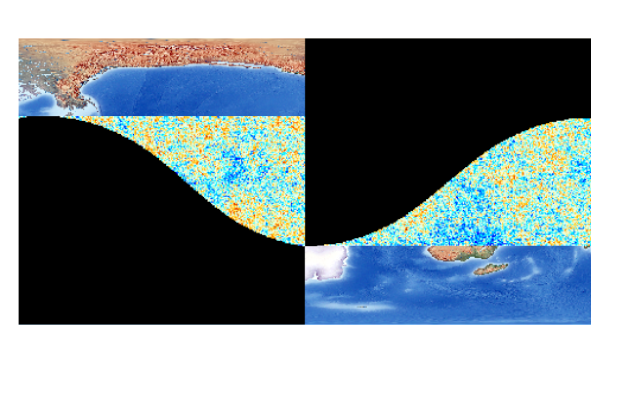
I think the custom transformations worked, but I'm having an issue with re-projecting and exporting the rasters. They render ok on the fly, but exporting to the new system leaves black empty areas in the output. I may just have a memory issue, I'm running Pro in a VM on my MacBook Pro. Note: ignore the "noise" in the 2nd image, that's actually a 2nd raster over the Natural Earth one.
- Mark as New
- Bookmark
- Subscribe
- Mute
- Subscribe to RSS Feed
- Permalink
I am sorry David. I am not sure why this is happening. I am tagging few people and groups on this post and maybe someone will be able to assist you.
Simon Woo Imagery and Remote Sensing
raster export raster projection export raster
- Mark as New
- Bookmark
- Subscribe
- Mute
- Subscribe to RSS Feed
- Permalink
Thanks. I'm going to iterate through some export options as well and see if something in the tool setup or environment settings is causing this.