- Home
- :
- All Communities
- :
- Developers
- :
- JavaScript Maps SDK
- :
- JavaScript Maps SDK Questions
- :
- Using FEMA rest end point
- Subscribe to RSS Feed
- Mark Topic as New
- Mark Topic as Read
- Float this Topic for Current User
- Bookmark
- Subscribe
- Mute
- Printer Friendly Page
- Mark as New
- Bookmark
- Subscribe
- Mute
- Subscribe to RSS Feed
- Permalink
I am trying to add FEMA map service
FEMA: Mapping Information Platform: NOPAGETAB_NFHLWMS
Index number 28 from above link.
I am doing this:
I know there is an scale of 50,000 but no matter my zoom it does not render in my map. I dont see any errors associated with this in the console
Thoughts?
var FloodZonelayer = new FeatureLayer("https://hazards.fema.gov/gis/nfhl/rest/services/public/NFHL/MapServer/28", {
mode: FeatureLayer.MODE_SNAPSHOT,
visible: true
});
legendLayers.push({ layer: FloodZonelayer, title: 'Flood Zones' });
map.addLayers([FloodZonelayer]);
Solved! Go to Solution.
Accepted Solutions
- Mark as New
- Bookmark
- Subscribe
- Mute
- Subscribe to RSS Feed
- Permalink
Jay,
Well you had a couple of issues in your code:
<!DOCTYPE html>
<html>
<head>
<meta charset="utf-8">
<meta name="viewport" content="initial-scale=1,maximum-scale=1,user-scalable=no">
<title>FeatureLayer</title>
<link rel="stylesheet" href="https://js.arcgis.com/3.23/esri/css/esri.css">
<script src="https://js.arcgis.com/3.23/"></script>
<style>
html, body, #map {
padding: 0;
margin: 0;
height: 100%;
width: 100%;
}
</style>
<script>
require([
"esri/map",
"esri/layers/ArcGISDynamicMapServiceLayer",
"esri/layers/ImageParameters",
"dojo/domReady!"
],
function(
Map,
ArcGISDynamicMapServiceLayer,
ImageParameters
) {
var map = new Map("map", {
basemap: "gray",
center: [-82.44109, 35.6122],
zoom: 17
});
var imageParameters = new ImageParameters();
imageParameters.format = "PNG32"; //set the image type to PNG24, note default is PNG8.
imageParameters.layerIds = [28];
imageParameters.layerOption = ImageParameters.LAYER_OPTION_SHOW;
var FloodZonelayer = new ArcGISDynamicMapServiceLayer("https://hazards.fema.gov/gis/nfhl/rest/services/public/NFHL/MapServer", {
"opacity" : 0.5,
"imageParameters" : imageParameters
});
map.addLayer(FloodZonelayer)
});
</script>
</head>
<body>
<div id="map"></div>
</body>
</html>
- Mark as New
- Bookmark
- Subscribe
- Mute
- Subscribe to RSS Feed
- Permalink
Jay,
FEMA seems to be having issue with that Map Service. All requests to it are failing.
- Mark as New
- Bookmark
- Subscribe
- Mute
- Subscribe to RSS Feed
- Permalink
OK thank you....was confused because I could open the Rest Endpoint in Chrome and query it and return data in the browser
- Mark as New
- Bookmark
- Subscribe
- Mute
- Subscribe to RSS Feed
- Permalink
Jay,
My queries have all failed and the links on the REST page to view the Map Service in the JS Viewer fail as well.
- Mark as New
- Bookmark
- Subscribe
- Mute
- Subscribe to RSS Feed
- Permalink
Yea my query attempts are failing now as well....hmmmm..
OK at least I am not going crazy here...lol...Patience I guess
- Mark as New
- Bookmark
- Subscribe
- Mute
- Subscribe to RSS Feed
- Permalink
Confused because I can view the layers here....I am copying the Rest EndPoint from this app and putting it in my JS app and it does not render.
Specifically Flood Hazard Zones - index 28
https://fema.maps.arcgis.com/home/webmap/viewer.html?webmap=cbe088e7c8704464aa0fc34eb99e7f30
- Mark as New
- Bookmark
- Subscribe
- Mute
- Subscribe to RSS Feed
- Permalink
Jay,
Which layer in that web map?..
- Mark as New
- Bookmark
- Subscribe
- Mute
- Subscribe to RSS Feed
- Permalink
index 28
Layer: Flood Hazard Zones (ID: 28)
it shows up in their app but fails when queried via the link above.
It renders here: https://fema.maps.arcgis.com/home/webmap/viewer.html?webmap=cbe088e7c8704464aa0fc34eb99e7f30
- Mark as New
- Bookmark
- Subscribe
- Mute
- Subscribe to RSS Feed
- Permalink
Jay,
Here is a sample that shows the layer does work it is just slo.....w:
<!DOCTYPE html>
<html>
<head>
<meta charset="utf-8">
<meta name="viewport" content="initial-scale=1,maximum-scale=1,user-scalable=no">
<title>FeatureLayer</title>
<link rel="stylesheet" href="https://js.arcgis.com/3.23/esri/css/esri.css">
<script src="https://js.arcgis.com/3.23/"></script>
<style>
html, body, #map {
padding: 0;
margin: 0;
height: 100%;
width: 100%;
}
</style>
<script>
require([
"esri/map",
"esri/layers/FeatureLayer",
"dojo/domReady!"
],
function(
Map,
FeatureLayer
) {
var map = new Map("map", {
basemap: "gray",
center: [-82.44109, 35.6122],
zoom: 17
});
var featureLayer = new FeatureLayer("https://hazards.fema.gov/gis/nfhl/rest/services/public/NFHL/MapServer/28");
map.addLayer(featureLayer);
});
</script>
</head>
<body>
<div id="map"></div>
</body>
</html>
- Mark as New
- Bookmark
- Subscribe
- Mute
- Subscribe to RSS Feed
- Permalink
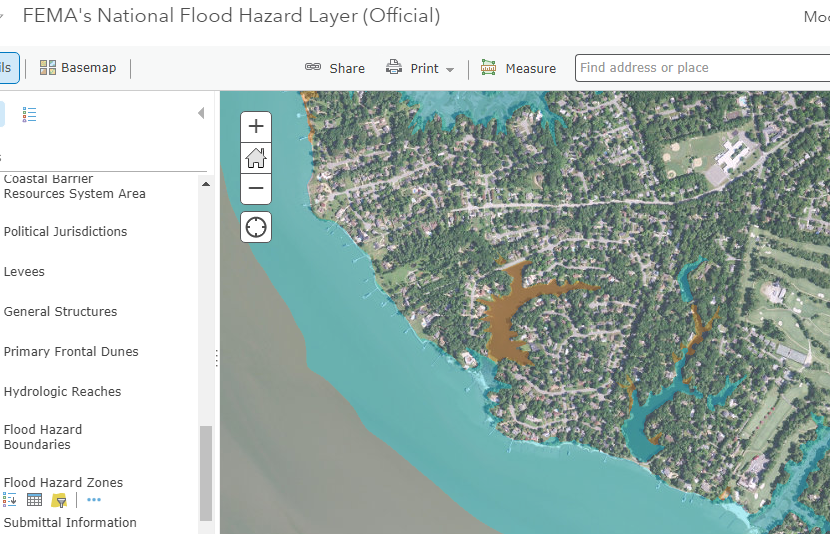
OK it seems to be working sort of...missing all the blue area in the water...
Are you seeing the blue in your app?
My App
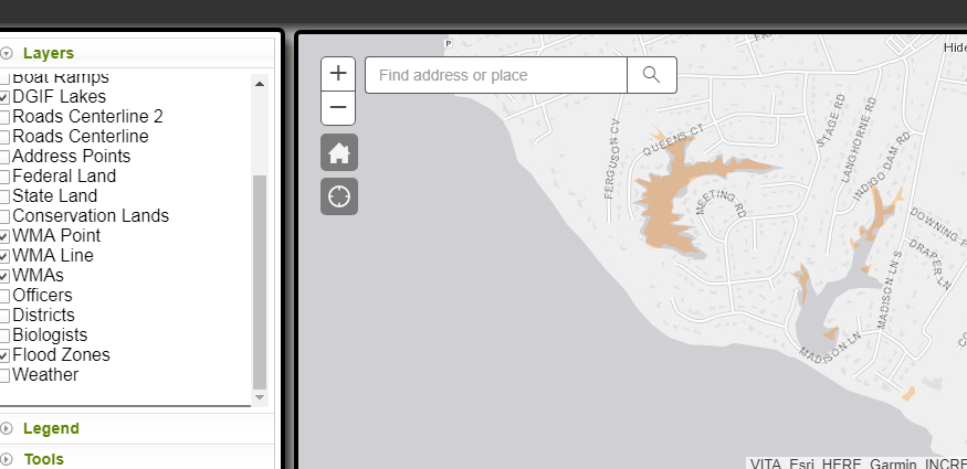
FEMA's App