- Home
- :
- All Communities
- :
- Products
- :
- Geoprocessing
- :
- Geoprocessing Questions
- :
- How to reproduce "cluster symbol" in ArcGIS Deskto...
- Subscribe to RSS Feed
- Mark Topic as New
- Mark Topic as Read
- Float this Topic for Current User
- Bookmark
- Subscribe
- Mute
- Printer Friendly Page
How to reproduce "cluster symbol" in ArcGIS Desktop or ArcGIS Pro
- Mark as New
- Bookmark
- Subscribe
- Mute
- Subscribe to RSS Feed
- Permalink
- Report Inappropriate Content
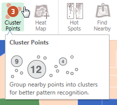
I really like the clustering symbology that's built into ArcGIS online and ArcGIS Maps for Office where at different zoom levels the points are aggregated together at a certain pixel tolerance.
Is there any way to do this in ArcGIS Desktop or ArcGIS Pro? Seems like the data for each zoom level would have to be created statically, but if I could create a modelbuilder to produce the results for the standard zoom levels it would be a handy thing to have around to improve visualization of certain datasets.
- Mark as New
- Bookmark
- Subscribe
- Mute
- Subscribe to RSS Feed
- Permalink
- Report Inappropriate Content
Hi Erika - yes, the Incident Analysis toolbox will do this in ArcMap and I believe ArcGIS Pro.
- Mark as New
- Bookmark
- Subscribe
- Mute
- Subscribe to RSS Feed
- Permalink
- Report Inappropriate Content
It would be helpful to replicate AGOL's symbol clustering without having to create a new feature class. Here's an example: I want to map public parking lots. If there are 5 parking lots on one property, I may not need a symbol for all 5 lots. Symbolizing as we do online would be preferable to creating a temporary file (that can be lost/broken) just for the map.
- Mark as New
- Bookmark
- Subscribe
- Mute
- Subscribe to RSS Feed
- Permalink
- Report Inappropriate Content
Looks like it's in the Product Plan - https://community.esri.com/ideas/5998-cluster-rendering-for-arcmap - hopefully AGP 2.3.