- Home
- :
- All Communities
- :
- User Groups
- :
- Web AppBuilder Custom Widgets
- :
- Questions
- :
- Re: Roberts Custom WAB Widgets
- Subscribe to RSS Feed
- Mark Topic as New
- Mark Topic as Read
- Float this Topic for Current User
- Bookmark
- Subscribe
- Mute
- Printer Friendly Page
Roberts Custom WAB Widgets
- Mark as New
- Bookmark
- Subscribe
- Mute
- Subscribe to RSS Feed
- Permalink
All,
Here is a list on my currently available Web AppBuilder widgets for Web AppBuilder 2.x
Enhanced Search Widget Version 2.21 - 11/16/21 Download Link
Enhanced Basemap Gallery Widget 2.8 - 05/01/2018 Download Link
Share Widget Superseded by esri OTB share widget
Share Widget Version 2.0.1 - 04/20/16 Download Link
Identify Widget Version 2.21 - 11/16/2021 Download Link
Elevation Profile Widget Version 2.17 - 09/19/2020 Download Link
Map Progress Indicator Widget Version 2.14 - 11/26/2019 Download Link
Enhanced Bookmark Widget Version 2.5 - 08/17/17 Download Link
Enhanced Locate Widget Version 2.16 - 08/21/2020 Download Link
Popup Panel Widget Version 2.17 - 9/1/20 Download Link
Aloha Threat Zone Widget Version 2.9 - 09/27/18 Download Link
Url Button Widget Version 2.5 - 08/10/2017 Download Link
Layer Toggle Button Widget Version 2.14 - 01/13/2020 Download Link
Feature Layer Hover Widget Version 2.12 - 09/05/2019 Download Link
Message was edited by: Robert Scheitlin, GISP 11/16/2021
- Mark as New
- Bookmark
- Subscribe
- Mute
- Subscribe to RSS Feed
- Permalink
Aloha Threat Zone Widget now available.
- Mark as New
- Bookmark
- Subscribe
- Mute
- Subscribe to RSS Feed
- Permalink
Outstanding. Thanks for the heads up. As always we really appreciate the effort in creating / maintaining these widgets.
~ Nick
- Mark as New
- Bookmark
- Subscribe
- Mute
- Subscribe to RSS Feed
- Permalink
This is wonderful news! Thanks,
Janie Goddard
Sent from my iPhone
- Mark as New
- Bookmark
- Subscribe
- Mute
- Subscribe to RSS Feed
- Permalink
Quick question Robert...I created my own PAS file and added it to your test site as well as my own Aloha test site with a measure tool added. It seems that there is a difference in the scale between what Aloha gives in its chart and what the tool displays on screen. In my example my chart maxed out at 6 miles. When I added the PAS file to the widget in either website it came out at 4.5 miles. I added the PAS file in the same location in your preview site as I did in our test site to make sure they appeared the same size. We also measured the length in ArcGIS to make sure there was not a measurement tool issue.
Any ideas? I originally thought we needed our data in a specific projection, but both of our sites do not utilize any other data but the ESRI basemap.
Thanks,
Nick
- Mark as New
- Bookmark
- Subscribe
- Mute
- Subscribe to RSS Feed
- Permalink
Nick,
So you are saying that the measurement should be 6 miles and it is 4.5? Can you zip your pas and attach it?
- Mark as New
- Bookmark
- Subscribe
- Mute
- Subscribe to RSS Feed
- Permalink
Yes...when I look at the image in Aloha it stopped the chart at 6 miles. So, the of the PAS image should be 6 miles in an app but it ends up 4.5 miles. This is the test.pas file. The other one I have attached test2.pas should be about 5.5 mile based on the Aloha image but ends up around 4.2 miles. What I found was the image appears to be about 33% smaller than the image shown in Aloha.
Here is the Image from Aloha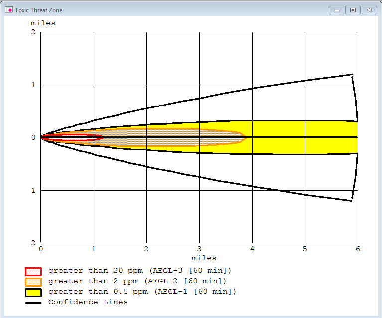
Here is a picture from a test app that I created with no other layers except the ESRI Basemap.

- Mark as New
- Bookmark
- Subscribe
- Mute
- Subscribe to RSS Feed
- Permalink
Nick,
I see the issue and should have it fixed today.
- Mark as New
- Bookmark
- Subscribe
- Mute
- Subscribe to RSS Feed
- Permalink
Great…thanks!
~ Nick
- Mark as New
- Bookmark
- Subscribe
- Mute
- Subscribe to RSS Feed
- Permalink
Hi Robert,
I just got around to the Aloha Widget and everything appears to be working correctly. Thanks again!