- Home
- :
- All Communities
- :
- Industries
- :
- Imagery and Remote Sensing Insights (IRIS) COP
- :
- Imagery Questions
- :
- Mosaic Dataset - rasters disappear when footprint ...
- Subscribe to RSS Feed
- Mark Topic as New
- Mark Topic as Read
- Float this Topic for Current User
- Bookmark
- Subscribe
- Mute
- Printer Friendly Page
Mosaic Dataset - rasters disappear when footprint attribute is edited
- Mark as New
- Bookmark
- Subscribe
- Mute
- Subscribe to RSS Feed
- Permalink
I am georeferencing Sanborn fire insurance map sheets in a mosaic database using ArcMap. I had the typical problem of seeing only a green wire frame after adding rasters. I edited the MaxPS and MinPS as has been recommended in the forums. I have done this before and it usually fixes the problem. Something new happened this time, for which I don't have a solution. I hope someone out there can help.
When I edited the Max PS and Min PS on the footprint attribute table of the mosaic database, the rasters became visible as usual, but when I saved the edits, some rasters disappear. Any ideas?
Solved! Go to Solution.
Accepted Solutions
- Mark as New
- Bookmark
- Subscribe
- Mute
- Subscribe to RSS Feed
- Permalink
Brian - please let us know if this resolves your need. Based on your description, I am guessing that the 'Max Number of Rasters per Mosaic' property (as mentioned by Peter) can enable you to display the missing rasters, but I thought it would be worth a bit more explanation re: "Why?".
re: 'Max Number of Rasters per Mosaic', we set a default of 20 to prevent poor performance if you attempt to view too many files. Yes, you can increase that value, and also adjust MinPS and MaxPS, but if you zoom out and expect to see hundreds of small images (requiring ArcGIS to open and display a large number of files) the result can be slow, especially if the source rasters don't have Pyramids.
This leads to other key issues to consider, including the use of Pyramids and Overviews (the latter mentioned by Ben). If you aren't familiar w/ them, both are reduced resolution views saved on disk to speed display. Pyramids are associated with each source raster, and Overviews are conceptually the same, but associated with the mosaic of multiple rasters. In my 2nd paragraph I referred to opening hundreds of files - If pyramids do not exist, ArcGIS has to resample each raster on the fly to generate the proper resolution, and that will take time. But even if pyramids do exist, we don't recommend attempting to display hundreds simply because opening a large number of files will still take time (thus the default of 20 individual rasters).
As Ben noted, when you zoom out, the system will automatically switch to displaying the appropriate Overviews if they exist. These are prebuilt reduced resolution views of the mosaic - so rather than displaying hundreds of individual rasters, you should have a very fast display of one or a small number of Overviews.
I hope this explains why you see green wire frames rather than images. You called it a "typical problem" but this is how the system was designed, to avoid slow performance. (You might ask "well, why doesn't ArcGIS just do this automatically?" but think about the case of thousands or millions of images - users would be very angry if we automatically started a process to generate Pyramids and they had to wait for hours just to see if the images were in the right place -- thus the green wireframes)
Two last notes: when you create Pyramids or Overviews, I recommend that you use Bilinear resampling rather than Nearest Neighbor, so the results look smooth. But no matter which resampling method is used, when you are working with raster versions of maps, at small scales you may find the view is not very useful. In that situation, I often recommend that you add a completely different dataset at an appropriate resolution (e.g. Landsat imagery, or a hillshaded terrain, or a 1:1,000,000 map etc.). It does not show your data, but it provides geographic context.
If you would like to read more, we have published the Image Management Guidebook that provides discussion of all of these parameters.
I hope this is helpful
Cody B.
- Mark as New
- Bookmark
- Subscribe
- Mute
- Subscribe to RSS Feed
- Permalink
Strange. Not seen this before. Note that when editing the Min/MaxPS values I usually use the 'Calculate' tool to quickly set the values, which does not require start/stop editing.
Two thing that come to mind that might be affecting the display, but neither really explain why the display would change when you stop editing:
A) There is a 'Max Number of Rasters per Mosaic' property. This defines for each request the max number of images that will be accessed in a single request. It is possible that you have gone beyond the default of 20. The system will display the first 20, but it may appear that others are missing. Its possible that after editing you displayed a slightly different area which result in a different ordering (say if you were on closet to center) and so some image appeared to disappear.
B) There is a 'Level' table that is generated that also controls which images get displayed when working with imagery of different resolutions. To check if this is causing the issue run 'Calculate Item Visibility'. In the Advanced option turn off 'Compute Min/Max Cell Sizes' (As this will reset your Min/MaxPS settings), but change the 'Cell Size Tolerance Factor' to 10. If you have images with varying pixel sizes and want them to be displayed at the same time then it is necessary to increase this value. (Its also a parameter in the MosaicDataset Properties/Default)
Is the issue reproducible? How many rasters are in the current mosaic dataset. IE do you see the issue if there are larger/fewer images?
- Mark as New
- Bookmark
- Subscribe
- Mute
- Subscribe to RSS Feed
- Permalink
Thanks Peter for your help and for that of the others. I think it is a combination of things that you mentioned and I will take this and the other excellent comments back for further reflection. I removed the mosaic dataset that was giving me problems and created a new one, then I added rasters with the create overview option (and advanced options for pyramids, cell statistics, and thumbnails.) All the rasters were then visible, so I didn't need to edit the MaxPS and MinPS values in the Footprint attribute table.
- Mark as New
- Bookmark
- Subscribe
- Mute
- Subscribe to RSS Feed
- Permalink
Have you tried creating overviews? I find this to be a much more reliable and efficient way of viewing my rasters at a large range of scales.
Once generated, I copy the overviews to a different mosaic and delete them from the original one to avoid the annoyance of having them fill up the attribute table with junk and making a mess of the footprint layer.
- Mark as New
- Bookmark
- Subscribe
- Mute
- Subscribe to RSS Feed
- Permalink
Ben
Thanks for offering this comment, but I am concerned that you feel the Overview records are junk and that the footprint layer is a mess. Perhaps the workaround you have described is acceptable to you, but if we can offer advice to improve the usability of your Mosaic Datasets, please let me know (you can contact me directly, or perhaps start a new thread listing your concerns)
Thanks
Cody B.
- Mark as New
- Bookmark
- Subscribe
- Mute
- Subscribe to RSS Feed
- Permalink
Hi Cody,
I can't see how direct message unless you 'follow' me and I don't think I have enough to add to warrant separate discussion so I'd just thought I'd say here that for me overviews are just a tool to help me visualise my hundreds or thousands of raster tiles, so I don't want or need to see them in the attribute table or the footprint layer. The footprints in particular are an irritant because they confuse the matter when trying to select the footprints of my source tiles - I can see no way to hide the footprints except by moving the overviews to another mosaic.
- Mark as New
- Bookmark
- Subscribe
- Mute
- Subscribe to RSS Feed
- Permalink
Ben
thanks, got it... I'm happy to advise if you have a future need but it sounds like you have a workflow that meets your needs -
Cody B.
- Mark as New
- Bookmark
- Subscribe
- Mute
- Subscribe to RSS Feed
- Permalink
Brian - please let us know if this resolves your need. Based on your description, I am guessing that the 'Max Number of Rasters per Mosaic' property (as mentioned by Peter) can enable you to display the missing rasters, but I thought it would be worth a bit more explanation re: "Why?".
re: 'Max Number of Rasters per Mosaic', we set a default of 20 to prevent poor performance if you attempt to view too many files. Yes, you can increase that value, and also adjust MinPS and MaxPS, but if you zoom out and expect to see hundreds of small images (requiring ArcGIS to open and display a large number of files) the result can be slow, especially if the source rasters don't have Pyramids.
This leads to other key issues to consider, including the use of Pyramids and Overviews (the latter mentioned by Ben). If you aren't familiar w/ them, both are reduced resolution views saved on disk to speed display. Pyramids are associated with each source raster, and Overviews are conceptually the same, but associated with the mosaic of multiple rasters. In my 2nd paragraph I referred to opening hundreds of files - If pyramids do not exist, ArcGIS has to resample each raster on the fly to generate the proper resolution, and that will take time. But even if pyramids do exist, we don't recommend attempting to display hundreds simply because opening a large number of files will still take time (thus the default of 20 individual rasters).
As Ben noted, when you zoom out, the system will automatically switch to displaying the appropriate Overviews if they exist. These are prebuilt reduced resolution views of the mosaic - so rather than displaying hundreds of individual rasters, you should have a very fast display of one or a small number of Overviews.
I hope this explains why you see green wire frames rather than images. You called it a "typical problem" but this is how the system was designed, to avoid slow performance. (You might ask "well, why doesn't ArcGIS just do this automatically?" but think about the case of thousands or millions of images - users would be very angry if we automatically started a process to generate Pyramids and they had to wait for hours just to see if the images were in the right place -- thus the green wireframes)
Two last notes: when you create Pyramids or Overviews, I recommend that you use Bilinear resampling rather than Nearest Neighbor, so the results look smooth. But no matter which resampling method is used, when you are working with raster versions of maps, at small scales you may find the view is not very useful. In that situation, I often recommend that you add a completely different dataset at an appropriate resolution (e.g. Landsat imagery, or a hillshaded terrain, or a 1:1,000,000 map etc.). It does not show your data, but it provides geographic context.
If you would like to read more, we have published the Image Management Guidebook that provides discussion of all of these parameters.
I hope this is helpful
Cody B.
- Mark as New
- Bookmark
- Subscribe
- Mute
- Subscribe to RSS Feed
- Permalink
Thanks very much Cody and to everyone else., I will use your comments to improve my work flow.
I mentioned above in a reply to Peter my way of resolving the issue for now, but need to learn more about working with rasters, so will use the information for process improvement.
- Mark as New
- Bookmark
- Subscribe
- Mute
- Subscribe to RSS Feed
- Permalink
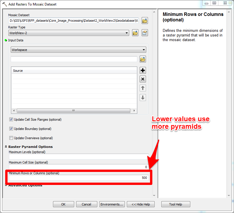
Hi Brian,
I see this has been resolved, but I wanted inform you of an optional setting you can apply on the Add Rasters to Mosaic Dataset GP tool that will help you control the scale at which your images will display. In the GP tool under Raster Pyramid Options, if you change the Minimum Rows and Columns value from 1500 to something lower (say 500), it will utilize more levels of pyramids. Try it without building overviews and you'll likely see all your images when displayed in ArcMap. This value essentially controls your MaxPS. Then when you build overviews, you'll build less overview levels because your using your pyramids instead.
The Raster Pyramid setting assumes you have pyramids or plan to build them with the Build Raster Pyramids checked in the GP tool. Think of it this way. If you're going to build pyramids, you may as well use them.