- Home
- :
- All Communities
- :
- Products
- :
- Geoprocessing
- :
- Geoprocessing Questions
- :
- Re: XY to Line OID Error (Error 000072), help?
- Subscribe to RSS Feed
- Mark Topic as New
- Mark Topic as Read
- Float this Topic for Current User
- Bookmark
- Subscribe
- Mute
- Printer Friendly Page
- Mark as New
- Bookmark
- Subscribe
- Mute
- Subscribe to RSS Feed
- Permalink
Hello,
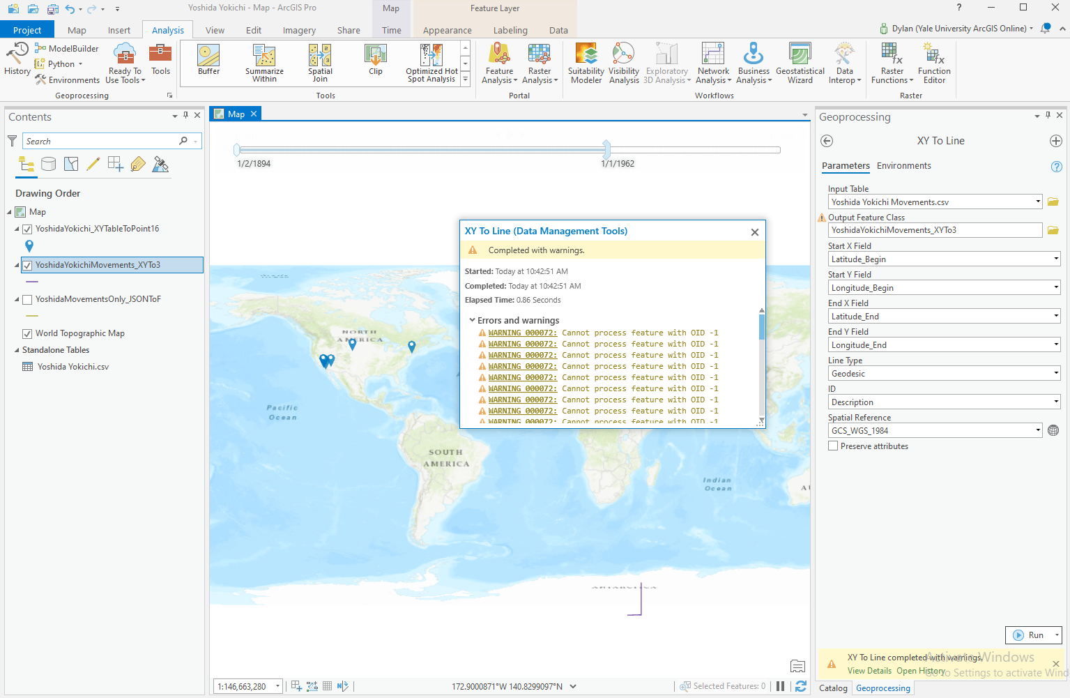
I am working to create a set of Geodesic lines from a CSV file, however after using the XY to Line tool, I receive only two vastly incorrect lines, and several warnings ("Warning 000072: Cannot process feature with OID -1")
I've also tried to run the repair geometry tool suggested at the link for Error 000072, however, I haven't had any luck with that.
Any help is appreciated as I am a novice with ArcGIS.
Thanks!
Solved! Go to Solution.
Accepted Solutions
- Mark as New
- Bookmark
- Subscribe
- Mute
- Subscribe to RSS Feed
- Permalink
It works for me...
I made sure that the Lat Long data in the excel worksheet were numeric in type before converting it to a table.

- Mark as New
- Bookmark
- Subscribe
- Mute
- Subscribe to RSS Feed
- Permalink
I suggest you perform a table to table to convert your csv file into a file geodatabase table and then try it again. You might also try first saving the csv to an excel worksheet and then apply excel to table converting it into a file geodatabase table. I don't have a ton of faith in either csv or excel; I prefer a real-live database table on which to apply geoprocessing tools.
- Mark as New
- Bookmark
- Subscribe
- Mute
- Subscribe to RSS Feed
- Permalink
Hi Joe,
Thanks for your suggestion. After trying to convert from CSV to GDB and XLSX to GDB, and then applying the XY to Line tool, I still got the same error (000072), although slightly different. Instead of "Cannot process feature with OID -1" I got the error "Cannot process feature with OID 1," "Cannot process feature with OID 2," and so on.
This project is essentially me pulling historical movement data of people out of oral histories, so I have the freedom to choose how I input data, whether CSV, XLS, or otherwise, and I chose CSV since I figured it would be fairly hassle free. GeoJSON posed no issues importing to feature, but I wanted to cut out the GeoJSON coding step.
Do you have any suggestions for a more succinct input method?
Thanks for your help.
- Mark as New
- Bookmark
- Subscribe
- Mute
- Subscribe to RSS Feed
- Permalink
Dear Joe,
I have the same error ("Warning 000072: Cannot process feature with OID -1"). I check the file there is no any NULL. Then I converted CSV file to Excel sheet using "table to table" but I still got the same error. Some lines appear on the map but not all of them. Also, the lines on the map seem to move out of the map. The original image should be the image named 1.jpg. But the error I get is the image named 2.jpg. Would you please help me?


- Mark as New
- Bookmark
- Subscribe
- Mute
- Subscribe to RSS Feed
- Permalink
Any chance you can post a few records of your data in a csv file here? I don't have any experience with that tool.
- Mark as New
- Bookmark
- Subscribe
- Mute
- Subscribe to RSS Feed
- Permalink
It works for me...
I made sure that the Lat Long data in the excel worksheet were numeric in type before converting it to a table.
- Mark as New
- Bookmark
- Subscribe
- Mute
- Subscribe to RSS Feed
- Permalink
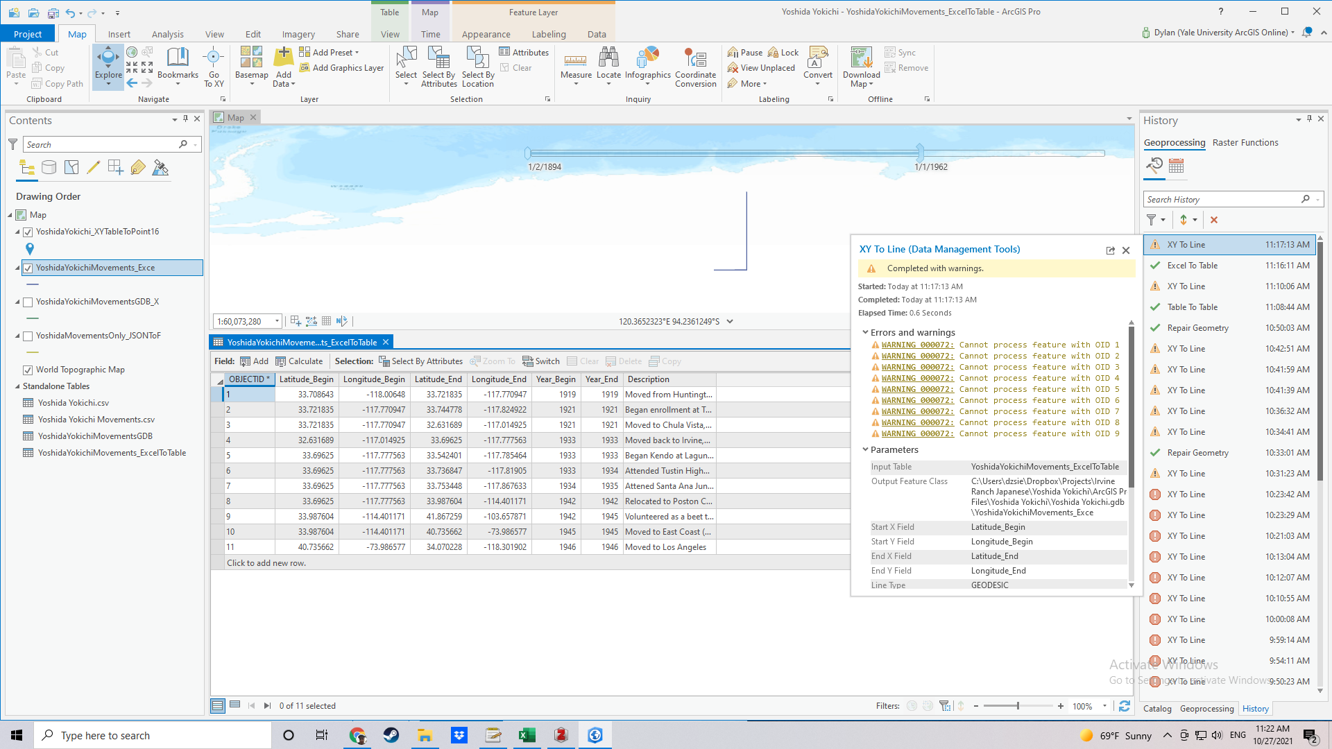
Thanks for your patience and showing me your work. I'm too embarrassed to say what the actual issue was, but it suffices to say that your screenshot allowed me to realize my very fundamental issue...
Cheers!
- Mark as New
- Bookmark
- Subscribe
- Mute
- Subscribe to RSS Feed
- Permalink
Let me guess: latitude and longitude values swapped? Happens all the time! (I had to double check myself before I ran the tool...)