- Home
- :
- All Communities
- :
- Products
- :
- Geoprocessing
- :
- Geoprocessing Questions
- :
- Re: Split By Attribute Tool
- Subscribe to RSS Feed
- Mark Topic as New
- Mark Topic as Read
- Float this Topic for Current User
- Bookmark
- Subscribe
- Mute
- Printer Friendly Page
Split By Attribute Tool
- Mark as New
- Bookmark
- Subscribe
- Mute
- Subscribe to RSS Feed
- Permalink
I found this tool very handy in splitting shapefiles by their attributes, and I wanted to share it hoping someone might get benefit of it.
- Mark as New
- Bookmark
- Subscribe
- Mute
- Subscribe to RSS Feed
- Permalink
Looks interesting. Prebuilt, so no need for Modelbuilder and/or coding to get the same results.
Chris Donohue, GISP
- Mark as New
- Bookmark
- Subscribe
- Mute
- Subscribe to RSS Feed
- Permalink
Been around as a free tool for some time .... only recently available at all license levels
- Mark as New
- Bookmark
- Subscribe
- Mute
- Subscribe to RSS Feed
- Permalink
I recently needed this function and found that tool today (The one by Dan). Is there anyway for it to output files into a gdb?
In my case, I needed it to split up a street maintenance plan by category, but when it splits the files out to a shapefile, it truncates the header name.
- Mark as New
- Bookmark
- Subscribe
- Mute
- Subscribe to RSS Feed
- Permalink
Unfortunately, the writeup states that geodatabases are untested and unsupported by this tool.
One can build a version of the same thing that will do geodatbase output with Modelbuilder. It could be done with an "Iterate Row Selection" iterator with the "Group by Fields" set to the category field. Then add a Copy Features tool to the right to save each selection that comes out of the Iterator as an output. Then to have the output name the file by category, you can use an in-line variable (see below):
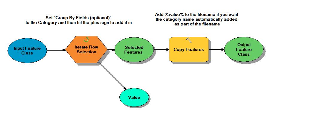
What is Modelbuilder
http://resources.arcgis.com/en/help/main/10.1/index.html#//002w00000001000000
Iterators
http://help.arcgis.com/en/arcgisdesktop/10.0/help/index.html#//00400000001n000000.htm
In-line Variable Substitution
Chris Donohue, GISP
- Mark as New
- Bookmark
- Subscribe
- Mute
- Subscribe to RSS Feed
- Permalink
In the works...but most of the effort has been to providing functionality so that the resultant outputs... ie shapefiles... can be used as inputs to other software and open-source GIS packages. If you can abide by the field length limitations of shapefiles then there is no issue. If you need long field names you will have to wait.
The next version will also output to other formats including csv and numpy arrays etc