- Home
- :
- All Communities
- :
- Products
- :
- Geoprocessing
- :
- Geoprocessing Questions
- :
- Re: Problems with "Add Field"
- Subscribe to RSS Feed
- Mark Topic as New
- Mark Topic as Read
- Float this Topic for Current User
- Bookmark
- Subscribe
- Mute
- Printer Friendly Page
- Mark as New
- Bookmark
- Subscribe
- Mute
- Subscribe to RSS Feed
- Permalink
Hello everyone!
I'm having problems to add a field on my shape's attribute table. When i try to add a Double column, it should show the options "scale" and "precision" for me to fill, but it keeps showing the options "alias", "allow null values" and "default value". How can i change that?
Thank you for the help!
P.S.: I'm using ArcGIS 10.
Solved! Go to Solution.
Accepted Solutions
- Mark as New
- Bookmark
- Subscribe
- Mute
- Subscribe to RSS Feed
- Permalink
shapefiles don't support alias
Add Field—Help | ArcGIS for Desktop
other readings
Working with fields in shapefiles by adding a field in ArcCatalog—Help | ArcGIS for Desktop
in geodatabase you can only change properties when the table is empty,
Alter Field—Help | ArcGIS for Desktop
and shapefiles would be the same
- Mark as New
- Bookmark
- Subscribe
- Mute
- Subscribe to RSS Feed
- Permalink
Make sure you're not in an edit session. I presume you changed the dropdown box to Double (or float or whatever the option is).
If it still persists, close all ArcMap sessions and try it again after reopening your map.
- Mark as New
- Bookmark
- Subscribe
- Mute
- Subscribe to RSS Feed
- Permalink
Hello Adrian.
I already tried that and it didn't work...
- Mark as New
- Bookmark
- Subscribe
- Mute
- Subscribe to RSS Feed
- Permalink
Can you paste a screen shot of what you're seeing exactly?
- Mark as New
- Bookmark
- Subscribe
- Mute
- Subscribe to RSS Feed
- Permalink
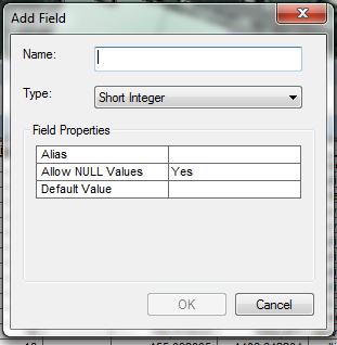
Here... This happens with all column types...
- Mark as New
- Bookmark
- Subscribe
- Mute
- Subscribe to RSS Feed
- Permalink
Interesting...I have the same issues (running 10.2 and 10.3).

- Mark as New
- Bookmark
- Subscribe
- Mute
- Subscribe to RSS Feed
- Permalink
Yeah, it's the exact same thing! But i need it to show "precision" and "scale" 
- Mark as New
- Bookmark
- Subscribe
- Mute
- Subscribe to RSS Feed
- Permalink
see my link below... precision and scale will vanish once the field is created but it is still visible in the properties of the table
- Mark as New
- Bookmark
- Subscribe
- Mute
- Subscribe to RSS Feed
- Permalink
Ok, this is weird. I am seeing the same things too (running ArcMap 10.3.1 on a Basic license).
However, these was happening with a File Geodatabase.
When I tried with a plain ole shapefile, it worked like it was supposed to...
Maybe setting precision and scale are not necessary within geodatabases? (but that doesn't sound right...)
- Mark as New
- Bookmark
- Subscribe
- Mute
- Subscribe to RSS Feed
- Permalink
I thought that was one of the magical things about geodatabases... there is no need to set them since they are controlled by the gdb themselves.. and from my link
- When you create a float, double, or integer field and specify 0 for precision and scale, the tool will attempt to create a binary type field if the underlying database supports it. Personal and file geodatabases support only binary type fields, and precision and scale are ignored.