- Home
- :
- All Communities
- :
- Products
- :
- Geoprocessing
- :
- Geoprocessing Questions
- :
- Re: Point specified distance from other point
- Subscribe to RSS Feed
- Mark Topic as New
- Mark Topic as Read
- Float this Topic for Current User
- Bookmark
- Subscribe
- Mute
- Printer Friendly Page
- Mark as New
- Bookmark
- Subscribe
- Mute
- Subscribe to RSS Feed
- Permalink
I am trying to place access points around the perimeter of parks on an OS map I downloaded, but given the large nature of the study area and limited knowledge of actual points of access, I am creating these at an average distance. For this reason, I want to find a way to place points a specific distance from the previous points (say 100m). I found tools such as intersection and direction-distance but these don't quite perform the more simplistic task I'm trying to accomplish.
The only thing I can think of trying is creating a buffer around each point and using the snapping tools to place new points, but this seems far too time consuming given the number of points involved.
Thanks.
Solved! Go to Solution.
Accepted Solutions
- Mark as New
- Bookmark
- Subscribe
- Mute
- Subscribe to RSS Feed
- Permalink
Robert,
if make sure you have snapping turned on, then use the construction tools to drop your first point where you want it. Then switch your construction tool to point at end of line. Snap to your first point the press control L this will allow you to type in a distance. Click on the map where you want your next point then press f2 (or just double click to finish line). Your point will be placed at the distance you set. Then just keep repeating with the point at end of line tool.
regards
Anthony
- Mark as New
- Bookmark
- Subscribe
- Mute
- Subscribe to RSS Feed
- Permalink
Without a picture of what you mean, the only thing that I can think of is the near tool but I somehow think that is not what you mean
- Mark as New
- Bookmark
- Subscribe
- Mute
- Subscribe to RSS Feed
- Permalink
Thanks for the help, I have attached an image to clarify.
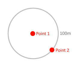
I wish for new points to be constrained to a 100m distance from the previous point created. This way, every new point I place can be a precise distance from the last. Hope this helps.
- Mark as New
- Bookmark
- Subscribe
- Mute
- Subscribe to RSS Feed
- Permalink
Robert,
if make sure you have snapping turned on, then use the construction tools to drop your first point where you want it. Then switch your construction tool to point at end of line. Snap to your first point the press control L this will allow you to type in a distance. Click on the map where you want your next point then press f2 (or just double click to finish line). Your point will be placed at the distance you set. Then just keep repeating with the point at end of line tool.
regards
Anthony
- Mark as New
- Bookmark
- Subscribe
- Mute
- Subscribe to RSS Feed
- Permalink
Perfect, exactly what I wanted. Thanks!
- Mark as New
- Bookmark
- Subscribe
- Mute
- Subscribe to RSS Feed
- Permalink
Robert,
Glad I could help. To help other users search please don't forget to add tags on your original question.
regards
Anthony
- Mark as New
- Bookmark
- Subscribe
- Mute
- Subscribe to RSS Feed
- Permalink
I've moved your post into the Geoprocessing space. I have also added in a few additional tags.
You can see more on the community structure, and what topics are under each
space from the following documents:
ArcGIS Discussion Forums Migration Strategy
Thanks!
Don