- Home
- :
- All Communities
- :
- Products
- :
- Geoprocessing
- :
- Geoprocessing Questions
- :
- LAS
- Subscribe to RSS Feed
- Mark Topic as New
- Mark Topic as Read
- Float this Topic for Current User
- Bookmark
- Subscribe
- Mute
- Printer Friendly Page
- Mark as New
- Bookmark
- Subscribe
- Mute
- Subscribe to RSS Feed
- Permalink
HI i have point xyz and can make LAS dataset?
Solved! Go to Solution.
Accepted Solutions
- Mark as New
- Bookmark
- Subscribe
- Mute
- Subscribe to RSS Feed
- Permalink
I don't have any video explaining the steps, but if you can share the, let's say' first 100 records of the XYZ file, I can see if I can provide some more explanation on the steps to accomplish this.
- Mark as New
- Bookmark
- Subscribe
- Mute
- Subscribe to RSS Feed
- Permalink
I have done this in the past using LAStools (LAStools: converting, filtering, viewing, processing, and compressing LIDAR data in LAS format ). See a description here:https://community.esri.com/thread/34075#comment-210089
According to the discussion in the idea: Ability to convert xyz point data to LAS format It should be part of the Data Interop extension.
- Mark as New
- Bookmark
- Subscribe
- Mute
- Subscribe to RSS Feed
- Permalink
have you any example video ?
- Mark as New
- Bookmark
- Subscribe
- Mute
- Subscribe to RSS Feed
- Permalink
I don't have any video explaining the steps, but if you can share the, let's say' first 100 records of the XYZ file, I can see if I can provide some more explanation on the steps to accomplish this.
- Mark as New
- Bookmark
- Subscribe
- Mute
- Subscribe to RSS Feed
- Permalink
I notice that you have 2 elevation values. Which one do you want to use in the output LAS file?
Is your decimal sign really a comma? This might need to be changed to point before processing the file, but I will confirm this.
- Mark as New
- Bookmark
- Subscribe
- Mute
- Subscribe to RSS Feed
- Permalink
IF IT ISNT PROBLEM USE ORTHOMTRIC ELEVATION
- Mark as New
- Bookmark
- Subscribe
- Mute
- Subscribe to RSS Feed
- Permalink
No problem.
So, you first go the website I mentioned before:
LAStools: converting, filtering, viewing, processing, and compressing LIDAR data in LAS format
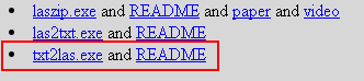
You can scroll down to the tool txt2las.exe and click it (or any other tool, since it will download a ZIP with all the tools):
Or use this direct link:
http://lastools.org/download/LAStools.zip
When you open the ZIP, you will notice that there is a large amount of information in it: In the LASTOOLS folder you will see a LICENSE.TXT file and you can verify that the txt2las is free:
This part of LAStools is "free" open-source LGPL (see COPYING.txt). To
purchase a different licensing model contact '[email protected]'.
* laszip
* lasindex
* lasvalidate
* lasliberate
* lasinfo
* las2las
* lasdiff
* lasmerge
* las2txt & txt2las
* lasprecision
* LASzip (with static linking exception)
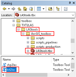
* LASlib (with LASzip) - the API used by LAStools.What you will also see, is that Martin Isenburg has included a toolbox that allows you to process the data directly in ArcGIS.
If you unzip the files to a local folder, you can navigate to the folder and find the LAStools.tbx. Inside you will find the tool txt2las. Double click to open the tool:
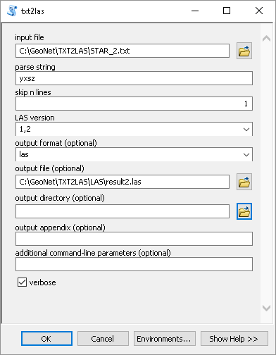
Before you load the tool, you will need to change the decimal sign into a dot, since the comma will be interpreted as a field separator and mess up the result. So, if you can, open the text file and change the decimal sign from coma to a dot:

When we look at order of the fields we will see, this order:
Y X skip Z
This is something that we will need to specify in the tool in order to interpret the data correctly:
So open the tool (if you haven't already) and specify the following:
- select the corrected text file
- use "yxsz" as parse string, this will read Y, X, skip the third attribute, Z
- skip 1 line (header)
- Choose the LAS version
- Select output format (las)
- Specify the output file
When you run the tool it will generate the LAS file and it will be loaded to ArcMap (at least in 10.6 it will):

When we identify a LAS point and compare it with the input data it corresponds:


- Mark as New
- Bookmark
- Subscribe
- Mute
- Subscribe to RSS Feed
- Permalink
I HAVE ARCGIS 10.4.1 IS PROBLEM THIS ?
- Mark as New
- Bookmark
- Subscribe
- Mute
- Subscribe to RSS Feed
- Permalink
It shouldn't be a problem, since the website mentions: All of the tools can also be run via a native GUI and are available as a LiDAR processing toolboxes for ArcGIS versions 9.3 and up
Did you try and did you get any error?