- Home
- :
- All Communities
- :
- Products
- :
- Geoprocessing
- :
- Geoprocessing Questions
- :
- Re: How to I determine if data points are located ...
- Subscribe to RSS Feed
- Mark Topic as New
- Mark Topic as Read
- Float this Topic for Current User
- Bookmark
- Subscribe
- Mute
- Printer Friendly Page
How to I determine if data points are located left or right of a contour line?
- Mark as New
- Bookmark
- Subscribe
- Mute
- Subscribe to RSS Feed
- Permalink
I have a two dimensional landscape with around 2000 xy points. I also have a single contour that winds its way through the landscape. I need to know how far each point is to the line, but i ultimately need the distance estimates to be polarized, so that points to the left have a negative distance, and those to the right have positive distances. A point exactly on the contour would have a distance of zero, and points further away have larger distance values.
I have been able to obtain distances from each point to the contour using the NEAR TABLE tool. Problem is they are all positive, and there are far too many points to eyeball each point to see if it is left or right of the contour. Is there a simple method for generating a list of xy points on each side of the contour, or a more efficient was of obtaining polarized measurements?
Thanks in advance
Sean
- Mark as New
- Bookmark
- Subscribe
- Mute
- Subscribe to RSS Feed
- Permalink
Not only is it relevant, it's critical. If the line passes north to south, then the "left" side is on the east.
- V
- Mark as New
- Bookmark
- Subscribe
- Mute
- Subscribe to RSS Feed
- Permalink
Hi Vince,
The image is oriented north/south, so yes, the split is east/west.
- Mark as New
- Bookmark
- Subscribe
- Mute
- Subscribe to RSS Feed
- Permalink
Getting back to my original point, did you determine the values and direction to the point using the near tool, and if so it looks like a that would allow you to rapidly split the points into left or right of the line. The analysis could be further enhanced by repeating the analysis with the contour direction flipped which would give two directions and the same point
- Mark as New
- Bookmark
- Subscribe
- Mute
- Subscribe to RSS Feed
- Permalink
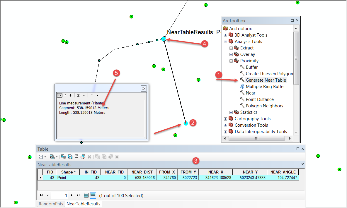
The attached image shows what can be done with the Generate Near Table tool if you have the appropriate licence.
1 start with the tool and generate a near table, add it as an event theme, using the Near_X, Near_Y to get the points shown on the polyline.
2 the points in the origin layer have been highlighted
3 the table contains all the information required to determine sided-ness depending upon the line of digitizing. The near angle field is the angle between the origin point and the point on the line with respect to the XY axis, in this case 104 degrees looks good
4 what I call the destination point...the point on the polyline
5 the distance was measured using the measure tool between the two points and the distance is pretty good within 0.000006 m (grief.... should have spent some snapping them )
This should give you some food for thought as to how to dissect your problem

- « Previous
-
- 1
- 2
- Next »
- « Previous
-
- 1
- 2
- Next »